Written and Fact-checked by Whereig Editors, Reviewed by Mukesh Kumar| Last Updated On: May 12, 2026
Map of Tallahatchie County - Tallahatchie County is a county located in the U.S. state of Mississippi. Tallahatchie County Map showing cities, highways, important places and water bodies. Get Where is Tallahatchie County located in the map, major cities in Tallahatchie county, population, areas, and places of interest.
Map of Tallahatchie County, Mississippi
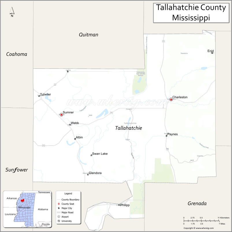
About Tallahatchie County Map, Mississippi: The map showing the county boundary, county seat, major cities, highways, water bodies and neighbouring counties.
Other Mississippi Maps & Info
Tallahatchie County, Mississippi
"Tallahatchie County is a county located in the U.S. state of Mississippi. It's county seat is Charleston, Sumner. As per 2020 census, the population of Tallahatchie County is 12366 people and population density is square miles. According to the United States Census Bureau, the county has a total area of 644 sq mi (1,668 km2). Tallahatchie County was established on 1833."
Tallahatchie County Facts
| Continent | North America |
| Country | United States |
| State | Mississippi |
| County Seat | Charleston and Sumner |
| Largest City/Town | Charleston |
| Established | 1833 |
| Total Area | 652 sq mi (1,689 sq km) |
| Land Area | 645 sq mi (1,671 sq km) |
| Water Area | 7 sq mi (18 sq km) |
| Population | 12,715 (Census 2020) |
| Population Density | 20 people per sq mi |
| Time Zone | Central Time Zone (CST/CDT) |
| Major Highways | Interstate 55, U.S. Route 49E, Mississippi Highway 32, Mississippi Highway 35 |
| Major Rivers | Tallahatchie River, Yocona River |
| Neighboring Counties | Tunica County, Panola County, Quitman County, Leflore County, Grenada County, Yalobusha County, Calhoun County |
| Famous For | Mississippi Delta history, blues heritage, and Emmett Till historical sites |
| Top Attractions | Emmett Till Interpretive Sites, Tallahatchie River, Charleston Historic District, and Delta heritage locations |
| Official Website | Official Website |
About Tallahatchie County, Mississippi
Tallahatchie County is located in the northwestern Mississippi Delta region of the southern United States and was established in 1833. The county has two county seats, Charleston and Sumner, with Charleston being the largest town. The county is known for its Delta farmland, civil rights history, blues culture, and scenic river landscapes.
Cities and Towns in Tallahatchie County, Mississippi
| City/Town | Population (Census 2020) | Latitude & Longitude |
|---|---|---|
| Charleston (county seat) | 1,892 | 33.9965°N, 90.0568°W |
| Sumner (county seat) | 269 | 33.9701°N, 90.3687°W |
| Tutwiler | 2,528 | 34.0140°N, 90.3948°W |
| Glendora | 151 | 33.8851°N, 90.2859°W |
| Webb | 528 | 33.9443°N, 90.2681°W |
| Enid | 595 | 34.0937°N, 89.7614°W |
| Swan Lake (CDP) | 255 | 34.1142°N, 90.2685°W |
Golf Courses in Tallahatchie County, Mississippi
| Golf Course | Location | Latitude & Longitude |
|---|---|---|
| Charleston Country Club | Charleston | 34.0068°N, 90.0502°W |
| Tallahatchie Golf Recreation Area | Tutwiler | 34.0132°N, 90.3914°W |
What Are the Major Roads and Highways in Tallahatchie County, Mississippi
Major highways connect the county to nearby Delta communities and regional destinations.
- Interstate 55 - major north-south interstate serving the eastern side of the county
- U.S. Route 49E - connects Tutwiler and Sumner with Greenwood and Clarksdale
- Mississippi Highway 32 - east-west route linking Charleston with nearby Delta towns
- Mississippi Highway 35 - serves local communities and agricultural areas throughout the county
What are the Neighboring Counties of Tallahatchie County
- Tunica County (northwest)
- Panola County (north)
- Yalobusha County (east)
- Calhoun County (southeast)
- Grenada County (south)
- Leflore County (south)
- Quitman County (west)
What Are the Top Attractions in Tallahatchie County, Mississippi
The county offers a mix of Delta heritage sites and historic attractions.
- Emmett Till Interpretive Center - historical site connected to the civil rights movement and Emmett Till history
- Tallahatchie River - scenic Delta river known for fishing and outdoor recreation
- Charleston Historic District - historic downtown area with preserved architecture and local history
- Sumner Courthouse - historic courthouse linked to the Emmett Till trial
- Tutwiler Blues Heritage Area - community associated with early Delta blues culture
- Glendora Delta Community - small historic Delta town with cultural significance
- Hopson Plantation vicinity - nearby historic Delta plantation area associated with blues history
- Enid Lake Recreation Area - nearby outdoor destination for boating, fishing, and camping
- Delta Agricultural Landscapes - scenic farmland representing traditional Mississippi Delta agriculture
- Swan Lake Area - quiet rural area known for natural scenery and wildlife
Distance from Tallahatchie County to Nearby Cities
The following distances are measured by road (driving).
- Charleston to Clarksdale (Coahoma County), Mississippi - 54 mi (87 km)
- Charleston to Greenwood (Leflore County), Mississippi - 41 mi (66 km)
- Charleston to Batesville (Panola County), Mississippi - 31 mi (50 km)
- Charleston to Grenada (Grenada County), Mississippi - 37 mi (60 km)
- Charleston to Oxford (Lafayette County), Mississippi - 49 mi (79 km)
- Charleston to Indianola (Sunflower County), Mississippi - 52 mi (84 km)
- Charleston to Jackson (Hinds County), Mississippi - 142 mi (229 km)
- Charleston to Memphis (Shelby County), Tennessee - 88 mi (142 km)
- Charleston to Sumner (Tallahatchie County), Mississippi - 22 mi (35 km)
- Charleston to Tutwiler (Tallahatchie County), Mississippi - 27 mi (43 km)
- Charleston to Webb (Tallahatchie County), Mississippi - 17 mi (27 km)
- Charleston to Cleveland (Bolivar County), Mississippi - 41 mi (66 km)
- Charleston to Water Valley (Yalobusha County), Mississippi - 42 mi (68 km)
FAQs about Tallahatchie County
Tallahatchie County is located in the Mississippi Delta region of northwestern Mississippi.
Tallahatchie County had a population of 12,715 according to the 2020 United States Census.
Tallahatchie County is known for Delta blues heritage, civil rights history, and the Emmett Till historical sites.
The county is served by Interstate 55, U.S. Route 49E, Mississippi Highway 32, and Mississippi Highway 35.
Yes, Tallahatchie County includes golf facilities such as Charleston Country Club and local recreation golf areas.
References
- QuickFacts - U.S. Census Bureau
- United States Census Bureau
- United States Geological Survey (USGS)
- National Geodetic Survey
- Official County Website
- Adams County Map
- Alcorn County Map
- Amite County Map
- Attala County Map
- Benton County Map
- Bolivar County Map
- Calhoun County Map
- Carroll County Map
- Chickasaw County Map
- Choctaw County Map
- Claiborne County Map
- Clarke County Map
- Clay County Map
- Coahoma County Map
- Copiah County Map
- Covington County Map
- DeSoto County Map
- Forrest County Map
- Franklin County Map
- George County Map
- Greene County Map
- Grenada County Map
- Hancock County Map
- Harrison County Map
- Hinds County Map
- Holmes County Map
- Humphreys County Map
- Issaquena County Map
- Itawamba County Map
- Jackson County Map
- Jasper County Map
- Jefferson County Map
- Jefferson Davis County Map
- Jones County Map
- Kemper County Map
- Lafayette County Map
- Lamar County Map
- Lauderdale County Map
- Lawrence County Map
- Leake County Map
- Lee County Map
- Leflore County Map
- Lincoln County Map
- Lowndes County Map
- Madison County Map
- Marion County Map
- Marshall County Map
- Monroe County Map
- Montgomery County Map
- Neshoba County Map
- Newton County Map
- Noxubee County Map
- Oktibbeha County Map
- Panola County Map
- Pearl River County Map
- Perry County Map
- Pike County Map
- Pontotoc County Map
- Prentiss County Map
- Quitman County Map
- Rankin County Map
- Scott County Map
- Sharkey County Map
- Simpson County Map
- Smith County Map
- Stone County Map
- Sunflower County Map
- Tallahatchie County Map
- Tate County Map
- Tippah County Map
- Tishomingo County Map
- Tunica County Map
- Union County Map
- Walthall County Map
- Warren County Map
- Washington County Map
- Wayne County Map
- Webster County Map
- Wilkinson County Map
- Winston County Map
- Yalobusha County Map
- Yazoo County Map
- Alabama Counties
- Alaska boroughs
- Arizona Counties
- Arkansas Counties
- California County Map
- Colorado Counties
- Connecticut Counties
- Delaware Counties
- Florida County Map
- Georgia County Map
- Hawaii Counties
- Idaho Counties
- Illinois Counties
- Indiana Counties
- Iowa Counties
- Kansas Counties
- Kentucky Counties
- Louisiana Counties
- Maine Counties
- Maryland Counties
- Massachusetts Counties
- Michigan County Map
- Minnesota Counties
- Mississippi Counties
- Missouri Counties
- Montana Counties
- Nebraska Counties
- Nevada Counties
- New York Counties
- New Hampshire Counties
- New Jersey Counties
- New Mexico Counties
- North Carolina Counties
- North Dakota Counties
- Ohio County Map
- Oklahoma Counties
- Oregon Counties
- Pennsylvania Counties
- Rhode Island Counties
- South Carolina Counties
- South Dakota Counties
- Map of Tennessee
- Texas County Map
- Utah Counties
- Vermont Counties
- Virginia Counties
- Washington Counties
- West Virginia Counties
- Wisconsin Counties
- Wyoming Counties