Written and Fact-checked by Whereig Editors, Reviewed by Mukesh Kumar| Last Updated On: May 12, 2026
Map of Franklin County - Franklin County is a county located in the U.S. state of Mississippi. Franklin County Map showing cities, highways, important places and water bodies. Get Where is Franklin County located in the map, major cities in Franklin county, population, areas, and places of interest.
Map of Franklin County, Mississippi
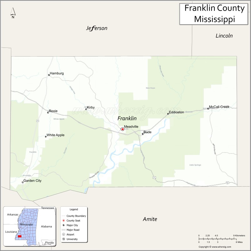
About Franklin County Map, Mississippi: The map showing the county boundary, county seat, major cities, highways, water bodies and neighbouring counties.
Other Mississippi Maps & Info
Franklin County, Mississippi
Franklin County is a county located in the U.S. state of Mississippi. It's county seat is Meadville. As per 2020 census, the population of Franklin County is 7676 people and population density is square miles. According to the United States Census Bureau, the county has a total area of 565 sq mi (1,463 km2). Franklin County was established on 1809.
Franklin County Facts
| Continent | North America |
| Country | United States |
| State | Mississippi |
| County Seat | Meadville |
| Largest City/Town | Meadville |
| Established | 1809 |
| Total Area | 565 sq mi (1,463 sq km) |
| Land Area | 564 sq mi (1,461 sq km) |
| Water Area | 1 sq mi (2.6 sq km) |
| Population | 7,726 (Census 2020) |
| Population Density | 13.7 people per sq mi |
| Time Zone | Central Time Zone |
| Major Highways | U.S. Route 84, Mississippi Highway 33, Mississippi Highway 98 |
| Major Rivers | Homochitto River, Mississippi River nearby watershed |
| Neighboring Counties | Jefferson County, Adams County, Lincoln County, Amite County, Wilkinson County |
| Famous For | Homochitto National Forest, outdoor recreation, and rural Mississippi heritage |
| Top Attractions | Homochitto National Forest, Meadville Historic District, and Caston Creek Recreation Area |
| Official Website | Official Website |
About Franklin County, Mississippi
Franklin County is located in southwestern Mississippi and was established in 1809. The county seat and largest town is Meadville. The county is known for its forests, scenic rivers, outdoor recreation opportunities, and peaceful rural communities surrounded by the Homochitto National Forest.
Cities and Towns in Franklin County, Mississippi
| City/Town | Population (Census 2020) | Latitude & Longitude |
|---|---|---|
| Meadville (county seat) | 448 | 31.4757°N, 90.8893°W |
| Bude | 950 | 31.4629°N, 90.8501°W |
| Roxie | 470 | 31.4901°N, 91.0626°W |
| McCall Creek nearby region | 1,000 | 31.5354°N, 90.7978°W |
Golf Courses in Franklin County, Mississippi
| Golf Course | Location | Latitude & Longitude |
|---|---|---|
| Meadville Community Golf Area | Meadville | 31.4792°N, 90.8941°W |
| Southwest Mississippi Golf Facilities nearby region | Nearby region | 31.4848°N, 90.9035°W |
What Are the Major Roads and Highways in Franklin County, Mississippi
Major highways connect Franklin County with southwest Mississippi communities and regional recreation areas.
- U.S. Route 84 - major east-west highway through southern Mississippi
- Mississippi Highway 33 - regional route serving forest and rural communities
- Mississippi Highway 98 - local highway connecting nearby towns and recreation sites
What are the Neighboring Counties of Franklin County
- Jefferson County (north)
- Lincoln County (east)
- Amite County (southeast)
- Wilkinson County (southwest)
- Adams County (west)
What Are the Top Attractions in Franklin County, Mississippi
The county offers outdoor recreation, forest landscapes, and historical attractions.
- Homochitto National Forest - expansive forest area with hiking, camping, hunting, and scenic drives
- Caston Creek Recreation Area - popular destination for camping, mountain biking, and nature exploration
- Meadville Historic District - small-town Southern district with historic architecture and local heritage
- Homochitto River Recreation Areas - fishing, canoeing, kayaking, and wildlife observation opportunities
- Scenic Southwest Mississippi Drives - countryside routes featuring forests and rolling hills
- Outdoor Recreation Areas - birdwatching, hiking, camping, and horseback riding opportunities
- Historic Churches and Community Landmarks - preserved sites reflecting regional culture and history
- Forest Wildlife Observation Areas - habitats supporting deer, birds, and native wildlife
- Community Festivals and Rural Heritage Events - annual celebrations showcasing local traditions
- Nature Photography Locations - scenic forest and river landscapes ideal for photography enthusiasts
Distance from Franklin County to Nearby Cities
The following distances are measured by road (driving).
- Meadville to Natchez, Mississippi - 39 mi (63 km)
- Meadville to Brookhaven, Mississippi - 42 mi (68 km)
- Meadville to Jackson, Mississippi - 91 mi (146 km)
- Meadville to Baton Rouge, Louisiana - 92 mi (148 km)
- Meadville to McComb, Mississippi - 44 mi (71 km)
- Meadville to Hattiesburg, Mississippi - 105 mi (169 km)
- Meadville to New Orleans, Louisiana - 157 mi (253 km)
- Meadville to Gulfport, Mississippi - 166 mi (267 km)
- Meadville to Mobile, Alabama - 231 mi (372 km)
- Meadville to Birmingham, Alabama - 287 mi (462 km)
- Meadville to Memphis, Tennessee - 290 mi (467 km)
- Meadville to Houston, Texas - 321 mi (517 km)
FAQs about Franklin County
Franklin County is located in southwestern Mississippi.
Franklin County had a population of 7,726 according to Census 2020 data.
Franklin County is known for Homochitto National Forest, outdoor recreation, and rural Mississippi heritage.
The county is served by U.S. Route 84, Mississippi Highway 33, and Mississippi Highway 98.
Yes, Franklin County has community golf and nearby regional recreation golf facilities.
References
- QuickFacts - U.S. Census Bureau
- United States Census Bureau
- Homochitto National Forest
- Visit Mississippi
- Official County Website
- Adams County Map
- Alcorn County Map
- Amite County Map
- Attala County Map
- Benton County Map
- Bolivar County Map
- Calhoun County Map
- Carroll County Map
- Chickasaw County Map
- Choctaw County Map
- Claiborne County Map
- Clarke County Map
- Clay County Map
- Coahoma County Map
- Copiah County Map
- Covington County Map
- DeSoto County Map
- Forrest County Map
- Franklin County Map
- George County Map
- Greene County Map
- Grenada County Map
- Hancock County Map
- Harrison County Map
- Hinds County Map
- Holmes County Map
- Humphreys County Map
- Issaquena County Map
- Itawamba County Map
- Jackson County Map
- Jasper County Map
- Jefferson County Map
- Jefferson Davis County Map
- Jones County Map
- Kemper County Map
- Lafayette County Map
- Lamar County Map
- Lauderdale County Map
- Lawrence County Map
- Leake County Map
- Lee County Map
- Leflore County Map
- Lincoln County Map
- Lowndes County Map
- Madison County Map
- Marion County Map
- Marshall County Map
- Monroe County Map
- Montgomery County Map
- Neshoba County Map
- Newton County Map
- Noxubee County Map
- Oktibbeha County Map
- Panola County Map
- Pearl River County Map
- Perry County Map
- Pike County Map
- Pontotoc County Map
- Prentiss County Map
- Quitman County Map
- Rankin County Map
- Scott County Map
- Sharkey County Map
- Simpson County Map
- Smith County Map
- Stone County Map
- Sunflower County Map
- Tallahatchie County Map
- Tate County Map
- Tippah County Map
- Tishomingo County Map
- Tunica County Map
- Union County Map
- Walthall County Map
- Warren County Map
- Washington County Map
- Wayne County Map
- Webster County Map
- Wilkinson County Map
- Winston County Map
- Yalobusha County Map
- Yazoo County Map
- Alabama Counties
- Alaska boroughs
- Arizona Counties
- Arkansas Counties
- California County Map
- Colorado Counties
- Connecticut Counties
- Delaware Counties
- Florida County Map
- Georgia County Map
- Hawaii Counties
- Idaho Counties
- Illinois Counties
- Indiana Counties
- Iowa Counties
- Kansas Counties
- Kentucky Counties
- Louisiana Counties
- Maine Counties
- Maryland Counties
- Massachusetts Counties
- Michigan County Map
- Minnesota Counties
- Mississippi Counties
- Missouri Counties
- Montana Counties
- Nebraska Counties
- Nevada Counties
- New York Counties
- New Hampshire Counties
- New Jersey Counties
- New Mexico Counties
- North Carolina Counties
- North Dakota Counties
- Ohio County Map
- Oklahoma Counties
- Oregon Counties
- Pennsylvania Counties
- Rhode Island Counties
- South Carolina Counties
- South Dakota Counties
- Map of Tennessee
- Texas County Map
- Utah Counties
- Vermont Counties
- Virginia Counties
- Washington Counties
- West Virginia Counties
- Wisconsin Counties
- Wyoming Counties