Written and Fact-checked by Whereig Editors, Reviewed by Mukesh Kumar| Last Updated On: May 12, 2026
Map of Leflore County - Leflore County is a county located in the U.S. state of Mississippi. Leflore County Map showing cities, highways, important places and water bodies. Get Where is Leflore County located in the map, major cities in Leflore county, population, areas, and places of interest.
Map of Leflore County, Mississippi
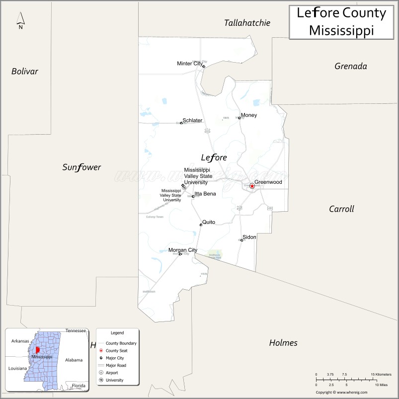
About Leflore County Map, Mississippi: The map showing the county boundary, county seat, major cities, highways, water bodies and neighbouring counties.
Other Mississippi Maps & Info
Leflore County, Mississippi
Leflore County is a county located in the U.S. state of Mississippi. It's county seat is Greenwood. As per 2020 census, the population of Leflore County is 27557 people and population density is square miles. According to the United States Census Bureau, the county has a total area of 592 sq mi (1,533 km2). Leflore County was established on 1871.
Leflore County Facts
| Continent | North America |
| Country | United States |
| State | Mississippi |
| County Seat | Greenwood |
| Largest City/Town | Greenwood |
| Established | 1871 |
| Total Area | 606 sq mi (1,570 sq km) |
| Land Area | 593 sq mi (1,536 sq km) |
| Water Area | 13 sq mi (34 sq km) |
| Population | 28,339 (Census 2020) |
| Population Density | 47.8 people per sq mi |
| Time Zone | Central Time Zone |
| Major Highways | U.S. Route 82, U.S. Route 49E, Mississippi Highway 7 |
| Major Rivers | Yazoo River, Tallahatchie River, Yalobusha River |
| Neighboring Counties | Carroll County, Grenada County, Sunflower County, Humphreys County, Tallahatchie County |
| Famous For | Mississippi Delta blues heritage, cotton farming, and Greenwood history |
| Top Attractions | B.B. King Museum nearby region, Greenwood Blues Heritage sites, and Viking Cooking School |
| Official Website | Official Website |
About Leflore County, Mississippi
Leflore County is located in the Mississippi Delta region and was established in 1871. The county seat and largest city is Greenwood. Leflore County is internationally known for its Delta blues history, agriculture, Southern cuisine, literary connections, and cultural influence on American music and food traditions.
Cities and Towns in Leflore County, Mississippi
| City/Town | Population (Census 2020) | Latitude & Longitude |
|---|---|---|
| Greenwood (county seat) | 14,490 | 33.5162°N, 90.1795°W |
| Itta Bena | 1,928 | 33.4951°N, 90.3198°W |
| Sidon | 417 | 33.4084°N, 90.2087°W |
| Morgan City | 204 | 33.4962°N, 90.2062°W |
| Schlater | 210 | 33.6387°N, 90.2968°W |
| Rising Sun nearby region | 500 | 33.5419°N, 90.1526°W |
Golf Courses in Leflore County, Mississippi
| Golf Course | Location | Latitude & Longitude |
|---|---|---|
| Greenwood Country Club | Greenwood | 33.5384°N, 90.1921°W |
| Whispering Pines Golf Club nearby region | Delta region | 33.5227°N, 90.1863°W |
| North Delta Golf Facilities nearby region | Greenwood area | 33.5140°N, 90.1748°W |
What Are the Major Roads and Highways in Leflore County
Major highways connect Leflore County with Mississippi Delta communities and regional commercial centers.
- U.S. Route 82 - major east-west transportation corridor across the Mississippi Delta
- U.S. Route 49E - north-south highway connecting Delta farming communities
- Mississippi Highway 7 - important regional route linking Greenwood with north Mississippi
What are the Neighboring Counties of Leflore County
- Grenada County (east)
- Carroll County (southeast)
- Humphreys County (south)
- Sunflower County (west)
- Tallahatchie County (north)
What Are the Top Attractions in Leflore County
The county offers blues heritage, Delta culture, museums, and outdoor recreation attractions.
- Greenwood Blues Heritage Sites - historic landmarks connected to Delta blues music history
- B.B. King Museum Nearby Region - cultural museum honoring blues legend B.B. King and Mississippi music heritage
- Viking Cooking School - nationally known culinary destination highlighting Southern cuisine
- Downtown Greenwood Historic District - restored buildings, boutiques, restaurants, and arts venues
- Mississippi Delta Cultural Experiences - tours and attractions celebrating Delta history and traditions
- Florewood River Plantation State Park Nearby Region - historic plantation and educational exhibits
- Tallahatchie and Yazoo River Recreation Areas - fishing, boating, and wildlife observation opportunities
- Howard Street Historic Architecture - preserved buildings reflecting Delta prosperity and culture
- Community Festivals and Blues Events - annual celebrations featuring music, arts, and Southern food
- Outdoor Hunting and Fishing Areas - popular Delta recreation destinations for sportsmen
Distance from Leflore County to Nearby Cities
The following distances are measured by road (driving).
- Greenwood to Greenville, Mississippi - 79 mi (127 km)
- Greenwood to Jackson, Mississippi - 96 mi (154 km)
- Greenwood to Oxford, Mississippi - 92 mi (148 km)
- Greenwood to Memphis, Tennessee - 135 mi (217 km)
- Greenwood to Tupelo, Mississippi - 140 mi (225 km)
- Greenwood to Little Rock, Arkansas - 170 mi (274 km)
- Greenwood to Birmingham, Alabama - 210 mi (338 km)
- Greenwood to New Orleans, Louisiana - 259 mi (417 km)
- Greenwood to Nashville, Tennessee - 286 mi (460 km)
- Greenwood to Atlanta, Georgia - 380 mi (612 km)
- Greenwood to Dallas, Texas - 421 mi (678 km)
- Greenwood to Houston, Texas - 451 mi (726 km)
FAQs about Leflore County
Leflore County is located in the Mississippi Delta region.
Leflore County had a population of 28,339 according to Census 2020 data.
Leflore County is known for Mississippi Delta blues heritage, cotton farming, and Greenwood history.
The county is served by U.S. Route 82, U.S. Route 49E, and Mississippi Highway 7.
Yes, Leflore County has golf facilities including Greenwood Country Club and nearby Delta golf courses.
References
- QuickFacts - U.S. Census Bureau
- United States Census Bureau
- Official County Website
- Visit Greenwood Mississippi
- B.B. King Museum
- Adams County Map
- Alcorn County Map
- Amite County Map
- Attala County Map
- Benton County Map
- Bolivar County Map
- Calhoun County Map
- Carroll County Map
- Chickasaw County Map
- Choctaw County Map
- Claiborne County Map
- Clarke County Map
- Clay County Map
- Coahoma County Map
- Copiah County Map
- Covington County Map
- DeSoto County Map
- Forrest County Map
- Franklin County Map
- George County Map
- Greene County Map
- Grenada County Map
- Hancock County Map
- Harrison County Map
- Hinds County Map
- Holmes County Map
- Humphreys County Map
- Issaquena County Map
- Itawamba County Map
- Jackson County Map
- Jasper County Map
- Jefferson County Map
- Jefferson Davis County Map
- Jones County Map
- Kemper County Map
- Lafayette County Map
- Lamar County Map
- Lauderdale County Map
- Lawrence County Map
- Leake County Map
- Lee County Map
- Leflore County Map
- Lincoln County Map
- Lowndes County Map
- Madison County Map
- Marion County Map
- Marshall County Map
- Monroe County Map
- Montgomery County Map
- Neshoba County Map
- Newton County Map
- Noxubee County Map
- Oktibbeha County Map
- Panola County Map
- Pearl River County Map
- Perry County Map
- Pike County Map
- Pontotoc County Map
- Prentiss County Map
- Quitman County Map
- Rankin County Map
- Scott County Map
- Sharkey County Map
- Simpson County Map
- Smith County Map
- Stone County Map
- Sunflower County Map
- Tallahatchie County Map
- Tate County Map
- Tippah County Map
- Tishomingo County Map
- Tunica County Map
- Union County Map
- Walthall County Map
- Warren County Map
- Washington County Map
- Wayne County Map
- Webster County Map
- Wilkinson County Map
- Winston County Map
- Yalobusha County Map
- Yazoo County Map
- Alabama Counties
- Alaska boroughs
- Arizona Counties
- Arkansas Counties
- California County Map
- Colorado Counties
- Connecticut Counties
- Delaware Counties
- Florida County Map
- Georgia County Map
- Hawaii Counties
- Idaho Counties
- Illinois Counties
- Indiana Counties
- Iowa Counties
- Kansas Counties
- Kentucky Counties
- Louisiana Counties
- Maine Counties
- Maryland Counties
- Massachusetts Counties
- Michigan County Map
- Minnesota Counties
- Mississippi Counties
- Missouri Counties
- Montana Counties
- Nebraska Counties
- Nevada Counties
- New York Counties
- New Hampshire Counties
- New Jersey Counties
- New Mexico Counties
- North Carolina Counties
- North Dakota Counties
- Ohio County Map
- Oklahoma Counties
- Oregon Counties
- Pennsylvania Counties
- Rhode Island Counties
- South Carolina Counties
- South Dakota Counties
- Map of Tennessee
- Texas County Map
- Utah Counties
- Vermont Counties
- Virginia Counties
- Washington Counties
- West Virginia Counties
- Wisconsin Counties
- Wyoming Counties