Written and Fact-checked by Whereig Editors, Reviewed by Mukesh Kumar| Last Updated On: May 12, 2026
Map of Jasper County - Jasper County is a county located in the U.S. state of Mississippi. Jasper County Map showing cities, highways, important places and water bodies. Get Where is Jasper County located in the map, major cities in Jasper county, population, areas, and places of interest.
Map of Jasper County, Mississippi
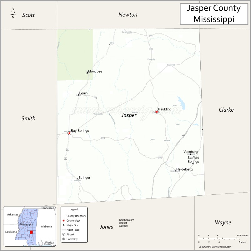
About Jasper County Map, Mississippi: The map showing the county boundary, county seat, major cities, highways, water bodies and neighbouring counties.
Other Mississippi Maps & Info
Jasper County, Mississippi
"Jasper County is a county located in the U.S. state of Mississippi. It's county seat is Bay Springs, Paulding. As per 2020 census, the population of Jasper County is 16291 people and population density is square miles. According to the United States Census Bureau, the county has a total area of 676 sq mi (1,751 km2). Jasper County was established on 1833."
Jasper County Facts
| Continent | North America |
| Country | United States |
| State | Mississippi |
| County Seat | Paulding and Bay Springs |
| Largest City/Town | Bay Springs |
| Established | 1833 |
| Total Area | 678 sq mi (1,756 sq km) |
| Land Area | 676 sq mi (1,751 sq km) |
| Water Area | 2 sq mi (5 sq km) |
| Population | 16,367 (Census 2020) |
| Population Density | 24.2 people per sq mi |
| Time Zone | Central Time Zone |
| Major Highways | Interstate 59, Mississippi Highway 15, Mississippi Highway 18 |
| Major Rivers | Leaf River, Chickasawhay River |
| Neighboring Counties | Jones County, Clarke County, Smith County, Newton County, Wayne County |
| Famous For | Forestry, outdoor recreation, and historic small-town Mississippi culture |
| Top Attractions | Bienville National Forest nearby region, Bay Springs Lake nearby region, and historic downtown Bay Springs |
| Official Website | Official Website |
About Jasper County, Mississippi
Jasper County is located in southeastern Mississippi and was established in 1833. The county has two county seats, Paulding and Bay Springs, with Bay Springs serving as the largest town. Jasper County is known for forestry, scenic landscapes, outdoor recreation, and its location near major waterways and national forest areas.
Cities and Towns in Jasper County, Mississippi
| City/Town | Population (Census 2020) | Latitude & Longitude |
|---|---|---|
| Bay Springs | 1,670 | 31.9790°N, 89.2870°W |
| Heidelberg | 641 | 31.8890°N, 88.9831°W |
| Louin | 277 | 32.0771°N, 89.2170°W |
| Montrose | 144 | 32.1335°N, 89.5545°W |
| Paulding (county seat) | 500 | 32.0243°N, 89.0356°W |
| Stringer nearby region | 1,000 | 31.8746°N, 89.2425°W |
Golf Courses in Jasper County, Mississippi
| Golf Course | Location | Latitude & Longitude |
|---|---|---|
| Bay Springs Country Club | Bay Springs | 31.9828°N, 89.2941°W |
| Southeast Mississippi Regional Golf Facilities nearby region | Nearby region | 31.9755°N, 89.2816°W |
What Are the Major Roads and Highways in Jasper County, Mississippi
Major highways connect Jasper County with southeastern Mississippi communities and regional recreation areas.
- Interstate 59 - major interstate connecting New Orleans and Birmingham
- Mississippi Highway 15 - north-south route serving Bay Springs and nearby communities
- Mississippi Highway 18 - east-west corridor linking regional towns and recreation destinations
What are the Neighboring Counties of Jasper County
- Newton County (north)
- Clarke County (east)
- Wayne County (southeast)
- Jones County (south)
- Smith County (west)
What Are the Top Attractions in Jasper County, Mississippi
The county offers scenic forests, outdoor recreation, and small-town Southern attractions.
- Bienville National Forest Nearby Region - outdoor recreation destination with hiking, camping, and wildlife observation
- Bay Springs Lake Nearby Region - boating, fishing, camping, and water recreation opportunities
- Historic Downtown Bay Springs - local shops, restaurants, and historic Southern architecture
- Tennessee-Tombigbee Waterway Nearby Areas - scenic waterways popular for fishing and boating
- Leaf River Recreation Areas - kayaking, canoeing, and nature exploration destinations
- Scenic Pine Forest Drives - countryside routes showcasing Mississippi timber landscapes
- Community Parks and Recreation Facilities - sports fields, playgrounds, and walking areas
- Historic Churches and Heritage Landmarks - preserved cultural sites reflecting local history
- Outdoor Hunting and Wildlife Areas - popular destinations for sportsmen and nature enthusiasts
- Annual Community Festivals and Heritage Events - celebrations featuring Southern traditions and local culture
Distance from Jasper County to Nearby Cities
The following distances are measured by road (driving).
- Bay Springs to Laurel, Mississippi - 30 mi (48 km)
- Bay Springs to Meridian, Mississippi - 56 mi (90 km)
- Bay Springs to Hattiesburg, Mississippi - 61 mi (98 km)
- Bay Springs to Jackson, Mississippi - 101 mi (163 km)
- Bay Springs to Gulfport, Mississippi - 120 mi (193 km)
- Bay Springs to Mobile, Alabama - 151 mi (243 km)
- Bay Springs to Birmingham, Alabama - 189 mi (304 km)
- Bay Springs to New Orleans, Louisiana - 172 mi (277 km)
- Bay Springs to Memphis, Tennessee - 284 mi (457 km)
- Bay Springs to Atlanta, Georgia - 318 mi (512 km)
- Bay Springs to Houston, Texas - 405 mi (652 km)
- Bay Springs to Dallas, Texas - 530 mi (853 km)
FAQs about Jasper County
Jasper County is located in southeastern Mississippi.
Jasper County had a population of 16,367 according to Census 2020 data.
Jasper County is known for forestry, outdoor recreation, and historic small-town Mississippi culture.
The county is served by Interstate 59, Mississippi Highway 15, and Mississippi Highway 18.
Yes, Jasper County has golf facilities including Bay Springs Country Club and nearby regional golf courses.
References
- QuickFacts - U.S. Census Bureau
- United States Census Bureau
- Official County Website
- Visit Mississippi
- U.S. Forest Service
- Adams County Map
- Alcorn County Map
- Amite County Map
- Attala County Map
- Benton County Map
- Bolivar County Map
- Calhoun County Map
- Carroll County Map
- Chickasaw County Map
- Choctaw County Map
- Claiborne County Map
- Clarke County Map
- Clay County Map
- Coahoma County Map
- Copiah County Map
- Covington County Map
- DeSoto County Map
- Forrest County Map
- Franklin County Map
- George County Map
- Greene County Map
- Grenada County Map
- Hancock County Map
- Harrison County Map
- Hinds County Map
- Holmes County Map
- Humphreys County Map
- Issaquena County Map
- Itawamba County Map
- Jackson County Map
- Jasper County Map
- Jefferson County Map
- Jefferson Davis County Map
- Jones County Map
- Kemper County Map
- Lafayette County Map
- Lamar County Map
- Lauderdale County Map
- Lawrence County Map
- Leake County Map
- Lee County Map
- Leflore County Map
- Lincoln County Map
- Lowndes County Map
- Madison County Map
- Marion County Map
- Marshall County Map
- Monroe County Map
- Montgomery County Map
- Neshoba County Map
- Newton County Map
- Noxubee County Map
- Oktibbeha County Map
- Panola County Map
- Pearl River County Map
- Perry County Map
- Pike County Map
- Pontotoc County Map
- Prentiss County Map
- Quitman County Map
- Rankin County Map
- Scott County Map
- Sharkey County Map
- Simpson County Map
- Smith County Map
- Stone County Map
- Sunflower County Map
- Tallahatchie County Map
- Tate County Map
- Tippah County Map
- Tishomingo County Map
- Tunica County Map
- Union County Map
- Walthall County Map
- Warren County Map
- Washington County Map
- Wayne County Map
- Webster County Map
- Wilkinson County Map
- Winston County Map
- Yalobusha County Map
- Yazoo County Map
- Alabama Counties
- Alaska boroughs
- Arizona Counties
- Arkansas Counties
- California County Map
- Colorado Counties
- Connecticut Counties
- Delaware Counties
- Florida County Map
- Georgia County Map
- Hawaii Counties
- Idaho Counties
- Illinois Counties
- Indiana Counties
- Iowa Counties
- Kansas Counties
- Kentucky Counties
- Louisiana Counties
- Maine Counties
- Maryland Counties
- Massachusetts Counties
- Michigan County Map
- Minnesota Counties
- Mississippi Counties
- Missouri Counties
- Montana Counties
- Nebraska Counties
- Nevada Counties
- New York Counties
- New Hampshire Counties
- New Jersey Counties
- New Mexico Counties
- North Carolina Counties
- North Dakota Counties
- Ohio County Map
- Oklahoma Counties
- Oregon Counties
- Pennsylvania Counties
- Rhode Island Counties
- South Carolina Counties
- South Dakota Counties
- Map of Tennessee
- Texas County Map
- Utah Counties
- Vermont Counties
- Virginia Counties
- Washington Counties
- West Virginia Counties
- Wisconsin Counties
- Wyoming Counties