Written and Fact-checked by Whereig Editors, Reviewed by Mukesh Kumar| Last Updated On: May 12, 2026
Map of Madison County - Madison County is a county located in the U.S. state of Mississippi. Madison County Map showing cities, highways, important places and water bodies. Get Where is Madison County located in the map, major cities in Madison county, population, areas, and places of interest.
Map of Madison County, Mississippi
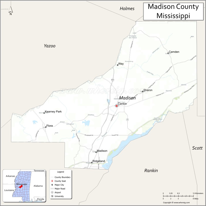
About Madison County Map, Mississippi: The map showing the county boundary, county seat, major cities, highways, water bodies and neighbouring counties.
Other Mississippi Maps & Info
Madison County, Mississippi
Madison County is a county located in the U.S. state of Mississippi. It's county seat is Canton. As per 2020 census, the population of Madison County is 109813 people and population density is square miles. According to the United States Census Bureau, the county has a total area of 719 sq mi (1,862 km2). Madison County was established on 1828.
Madison County Facts
| Continent | North America |
| Country | United States |
| State | Mississippi |
| County Seat | Canton |
| Largest City/Town | Madison |
| Established | 1828 |
| Total Area | 742 sq mi (1,922 sq km) |
| Land Area | 715 sq mi (1,852 sq km) |
| Water Area | 27 sq mi (70 sq km) |
| Population | 109,145 (Census 2020) |
| Population Density | 152.6 people per sq mi |
| Time Zone | Central Time Zone |
| Major Highways | Interstate 55, Interstate 220 nearby region, Natchez Trace Parkway |
| Major Rivers | Pearl River, Big Black River nearby watershed |
| Neighboring Counties | Hinds County, Rankin County, Yazoo County, Leake County, Holmes County |
| Famous For | Affluent suburbs, historic Canton, and automotive manufacturing |
| Top Attractions | Natchez Trace Parkway, Renaissance at Colony Park, and Canton Historic District |
| Official Website | Official Website |
About Madison County, Mississippi
Madison County is located in central Mississippi north of Jackson and was established in 1828. The county seat is Canton, while the city of Madison is the largest municipality. Madison County is known for upscale residential communities, strong economic growth, historic downtown districts, excellent schools, and major industrial development including automotive manufacturing.
Cities and Towns in Madison County, Mississippi
| City/Town | Population (Census 2020) | Latitude & Longitude |
|---|---|---|
| Madison | 27,747 | 32.4610°N, 90.1154°W |
| Canton (county seat) | 10,948 | 32.6126°N, 90.0368°W |
| Ridgeland | 24,275 | 32.4285°N, 90.1320°W |
| Flora | 1,886 | 32.5432°N, 90.3090°W |
| Gluckstadt | 3,200 | 32.5249°N, 90.1106°W |
| Camden nearby region | 900 | 32.7857°N, 89.8739°W |
Golf Courses in Madison County, Mississippi
| Golf Course | Location | Latitude & Longitude |
|---|---|---|
| Annandale Golf Club | Madison | 32.4568°N, 90.1536°W |
| Reunion Golf and Country Club | Madison area | 32.4998°N, 90.0467°W |
| Lake Caroline Golf Club | Madison County | 32.5731°N, 90.0615°W |
What Are the Major Roads and Highways in Madison County
Major highways make Madison County one of the most accessible and rapidly growing regions in Mississippi.
- Interstate 55 - major north-south interstate linking Jackson, Memphis, and New Orleans
- Interstate 220 nearby region - beltway connector serving the Jackson metropolitan area
- Natchez Trace Parkway - scenic historic roadway and recreation route
What are the Neighboring Counties of Madison County
- Holmes County (north)
- Leake County (east)
- Rankin County (southeast)
- Hinds County (southwest)
- Yazoo County (west)
What Are the Top Attractions in Madison County
The county offers upscale shopping, historic attractions, outdoor recreation, and cultural experiences.
- Natchez Trace Parkway - scenic driving route with hiking, cycling, and historic sites
- Renaissance at Colony Park - premier shopping, dining, and entertainment destination in Ridgeland
- Canton Historic District - downtown area featuring courthouse square, antique shops, and Southern architecture
- Mississippi Crafts Center - exhibits and galleries showcasing regional artisans and handcrafted works
- Ross Barnett Reservoir Nearby Region - boating, fishing, camping, and water recreation destination
- Annandale Golf Club - championship golf course and upscale recreational facility
- Madison Historic Railroad District - restored buildings and local cultural attractions
- Canton Movie Heritage Sites - filming locations used in major Hollywood productions
- Community Parks and Nature Trails - family recreation areas throughout the county
- Annual Festivals and Holiday Events - celebrations featuring arts, music, and Southern traditions
Distance from Madison County to Nearby Cities
The following distances are measured by road (driving).
- Madison to Jackson, Mississippi - 12 mi (19 km)
- Madison to Vicksburg, Mississippi - 55 mi (89 km)
- Madison to Meridian, Mississippi - 95 mi (153 km)
- Madison to Memphis, Tennessee - 208 mi (335 km)
- Madison to Hattiesburg, Mississippi - 103 mi (166 km)
- Madison to Birmingham, Alabama - 239 mi (385 km)
- Madison to Baton Rouge, Louisiana - 169 mi (272 km)
- Madison to New Orleans, Louisiana - 186 mi (299 km)
- Madison to Mobile, Alabama - 243 mi (391 km)
- Madison to Atlanta, Georgia - 382 mi (615 km)
- Madison to Dallas, Texas - 395 mi (636 km)
- Madison to Houston, Texas - 355 mi (571 km)
FAQs about Madison County
Madison County is located in central Mississippi north of Jackson.
Madison County had a population of 109,145 according to Census 2020 data.
Madison County is known for affluent suburbs, historic Canton, and automotive manufacturing.
The county is served by Interstate 55, Interstate 220 nearby region, and the Natchez Trace Parkway.
Yes, Madison County has golf facilities including Annandale Golf Club and Reunion Golf and Country Club.
References
- QuickFacts - U.S. Census Bureau
- United States Census Bureau
- Official County Website
- Natchez Trace Parkway
- Explore Ridgeland
- Adams County Map
- Alcorn County Map
- Amite County Map
- Attala County Map
- Benton County Map
- Bolivar County Map
- Calhoun County Map
- Carroll County Map
- Chickasaw County Map
- Choctaw County Map
- Claiborne County Map
- Clarke County Map
- Clay County Map
- Coahoma County Map
- Copiah County Map
- Covington County Map
- DeSoto County Map
- Forrest County Map
- Franklin County Map
- George County Map
- Greene County Map
- Grenada County Map
- Hancock County Map
- Harrison County Map
- Hinds County Map
- Holmes County Map
- Humphreys County Map
- Issaquena County Map
- Itawamba County Map
- Jackson County Map
- Jasper County Map
- Jefferson County Map
- Jefferson Davis County Map
- Jones County Map
- Kemper County Map
- Lafayette County Map
- Lamar County Map
- Lauderdale County Map
- Lawrence County Map
- Leake County Map
- Lee County Map
- Leflore County Map
- Lincoln County Map
- Lowndes County Map
- Madison County Map
- Marion County Map
- Marshall County Map
- Monroe County Map
- Montgomery County Map
- Neshoba County Map
- Newton County Map
- Noxubee County Map
- Oktibbeha County Map
- Panola County Map
- Pearl River County Map
- Perry County Map
- Pike County Map
- Pontotoc County Map
- Prentiss County Map
- Quitman County Map
- Rankin County Map
- Scott County Map
- Sharkey County Map
- Simpson County Map
- Smith County Map
- Stone County Map
- Sunflower County Map
- Tallahatchie County Map
- Tate County Map
- Tippah County Map
- Tishomingo County Map
- Tunica County Map
- Union County Map
- Walthall County Map
- Warren County Map
- Washington County Map
- Wayne County Map
- Webster County Map
- Wilkinson County Map
- Winston County Map
- Yalobusha County Map
- Yazoo County Map
- Alabama Counties
- Alaska boroughs
- Arizona Counties
- Arkansas Counties
- California County Map
- Colorado Counties
- Connecticut Counties
- Delaware Counties
- Florida County Map
- Georgia County Map
- Hawaii Counties
- Idaho Counties
- Illinois Counties
- Indiana Counties
- Iowa Counties
- Kansas Counties
- Kentucky Counties
- Louisiana Counties
- Maine Counties
- Maryland Counties
- Massachusetts Counties
- Michigan County Map
- Minnesota Counties
- Mississippi Counties
- Missouri Counties
- Montana Counties
- Nebraska Counties
- Nevada Counties
- New York Counties
- New Hampshire Counties
- New Jersey Counties
- New Mexico Counties
- North Carolina Counties
- North Dakota Counties
- Ohio County Map
- Oklahoma Counties
- Oregon Counties
- Pennsylvania Counties
- Rhode Island Counties
- South Carolina Counties
- South Dakota Counties
- Map of Tennessee
- Texas County Map
- Utah Counties
- Vermont Counties
- Virginia Counties
- Washington Counties
- West Virginia Counties
- Wisconsin Counties
- Wyoming Counties