Written and Fact-checked by Whereig Editors, Reviewed by Mukesh Kumar| Last Updated On: May 12, 2026
Map of Montgomery County - Montgomery County is a county located in the U.S. state of Mississippi. Montgomery County Map showing cities, highways, important places and water bodies. Get Where is Montgomery County located in the map, major cities in Montgomery county, population, areas, and places of interest.
Map of Montgomery County, Mississippi
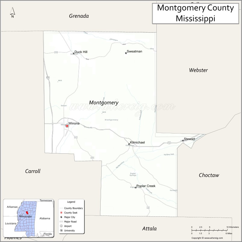
About Montgomery County Map, Mississippi: The map showing the county boundary, county seat, major cities, highways, water bodies and neighbouring counties.
Other Mississippi Maps & Info
Montgomery County, Mississippi
Montgomery County is a county located in the U.S. state of Mississippi. It's county seat is Winona. As per 2020 census, the population of Montgomery County is 9729 people and population density is square miles. According to the United States Census Bureau, the county has a total area of 407 sq mi (1,054 km2). Montgomery County was established on 1871.
Montgomery County Facts
| Continent | North America |
| Country | United States |
| State | Mississippi |
| County Seat | Winona |
| Largest City/Town | Winona |
| Established | 1871 |
| Total Area | 408 sq mi (1,057 sq km) |
| Land Area | 407 sq mi (1,054 sq km) |
| Water Area | 1 sq mi (2.6 sq km) |
| Population | 9,123 (Census 2020) |
| Population Density | 22.4 people per sq mi |
| Time Zone | Central Time Zone |
| Major Highways | Interstate 55, U.S. Route 51, Mississippi Highway 407 |
| Major Rivers | Big Black River nearby watershed, Yalobusha River nearby region |
| Neighboring Counties | Carroll County, Attala County, Grenada County, Webster County, Choctaw County |
| Famous For | Historic Winona, timber industry, and North Central Mississippi heritage |
| Top Attractions | Winona Historic District, Duck Hill nearby region, and scenic countryside drives |
| Official Website | Official Website |
About Montgomery County, Mississippi
Montgomery County is located in north-central Mississippi and was established in 1871. The county seat and largest city is Winona. Montgomery County is known for its railroad heritage, timber and agricultural industries, historic downtown districts, and scenic rolling countryside.
Cities and Towns in Montgomery County, Mississippi
| City/Town | Population (Census 2020) | Latitude & Longitude |
|---|---|---|
| Winona (county seat) | 4,955 | 33.4829°N, 89.7284°W |
| Duck Hill | 632 | 33.6251°N, 89.7118°W |
| Kilmichael | 639 | 33.4371°N, 89.5734°W |
| Elliott nearby region | 1,000 | 33.6918°N, 89.7503°W |
| Stewart nearby region | 500 | 33.4516°N, 89.4442°W |
Golf Courses in Montgomery County, Mississippi
| Golf Course | Location | Latitude & Longitude |
|---|---|---|
| Winona Country Club | Winona | 33.4906°N, 89.7348°W |
| North Central Mississippi Golf Facilities nearby region | Nearby region | 33.4789°N, 89.7194°W |
| Regional Recreation Golf Courses nearby region | Winona area | 33.4857°N, 89.7261°W |
What Are the Major Roads and Highways in Montgomery County
Major highways connect Montgomery County with central and northern Mississippi communities.
- Interstate 55 - major north-south interstate linking Jackson and Memphis
- U.S. Route 51 - historic transportation corridor through Winona
- Mississippi Highway 407 - regional connector serving rural communities and agricultural areas
What are the Neighboring Counties of Montgomery County
- Grenada County (north)
- Webster County (east)
- Choctaw County (southeast)
- Attala County (south)
- Carroll County (west)
What Are the Top Attractions in Montgomery County
The county offers historic landmarks, outdoor recreation, and scenic North Mississippi landscapes.
- Winona Historic District - downtown area featuring historic architecture, shops, and local restaurants
- Duck Hill Nearby Region - small-town heritage area with historic churches and community traditions
- Scenic Countryside Drives - rolling hills, forests, and farmland throughout north-central Mississippi
- Winona Railroad Heritage Sites - attractions connected to the region’s transportation history
- Community Parks and Recreation Facilities - sports fields, walking trails, and family recreation areas
- Outdoor Hunting and Fishing Areas - recreation opportunities in forest and rural landscapes
- Historic Cemeteries and Churches - preserved cultural landmarks reflecting local heritage
- Regional Antique Shops and Markets - destinations featuring crafts and Southern collectibles
- Annual Community Festivals and Heritage Events - celebrations highlighting local traditions and culture
- Nature Observation and Birdwatching Areas - habitats supporting native Mississippi wildlife
Distance from Montgomery County to Nearby Cities
The following distances are measured by road (driving).
- Winona to Jackson, Mississippi - 96 mi (154 km)
- Winona to Greenwood, Mississippi - 39 mi (63 km)
- Winona to Tupelo, Mississippi - 108 mi (174 km)
- Winona to Oxford, Mississippi - 84 mi (135 km)
- Winona to Memphis, Tennessee - 152 mi (245 km)
- Winona to Starkville, Mississippi - 83 mi (134 km)
- Winona to Birmingham, Alabama - 184 mi (296 km)
- Winona to Little Rock, Arkansas - 181 mi (291 km)
- Winona to Nashville, Tennessee - 267 mi (430 km)
- Winona to New Orleans, Louisiana - 279 mi (449 km)
- Winona to Dallas, Texas - 420 mi (676 km)
- Winona to Houston, Texas - 451 mi (726 km)
FAQs about Montgomery County
Montgomery County is located in north-central Mississippi.
Montgomery County had a population of 9,123 according to Census 2020 data.
Montgomery County is known for historic Winona, the timber industry, and North Central Mississippi heritage.
The county is served by Interstate 55, U.S. Route 51, and Mississippi Highway 407.
Yes, Montgomery County has golf facilities including Winona Country Club and nearby regional golf courses.
References
- QuickFacts - U.S. Census Bureau
- United States Census Bureau
- Official County Website
- Visit Mississippi
- Natchez Trace Parkway
- Adams County Map
- Alcorn County Map
- Amite County Map
- Attala County Map
- Benton County Map
- Bolivar County Map
- Calhoun County Map
- Carroll County Map
- Chickasaw County Map
- Choctaw County Map
- Claiborne County Map
- Clarke County Map
- Clay County Map
- Coahoma County Map
- Copiah County Map
- Covington County Map
- DeSoto County Map
- Forrest County Map
- Franklin County Map
- George County Map
- Greene County Map
- Grenada County Map
- Hancock County Map
- Harrison County Map
- Hinds County Map
- Holmes County Map
- Humphreys County Map
- Issaquena County Map
- Itawamba County Map
- Jackson County Map
- Jasper County Map
- Jefferson County Map
- Jefferson Davis County Map
- Jones County Map
- Kemper County Map
- Lafayette County Map
- Lamar County Map
- Lauderdale County Map
- Lawrence County Map
- Leake County Map
- Lee County Map
- Leflore County Map
- Lincoln County Map
- Lowndes County Map
- Madison County Map
- Marion County Map
- Marshall County Map
- Monroe County Map
- Montgomery County Map
- Neshoba County Map
- Newton County Map
- Noxubee County Map
- Oktibbeha County Map
- Panola County Map
- Pearl River County Map
- Perry County Map
- Pike County Map
- Pontotoc County Map
- Prentiss County Map
- Quitman County Map
- Rankin County Map
- Scott County Map
- Sharkey County Map
- Simpson County Map
- Smith County Map
- Stone County Map
- Sunflower County Map
- Tallahatchie County Map
- Tate County Map
- Tippah County Map
- Tishomingo County Map
- Tunica County Map
- Union County Map
- Walthall County Map
- Warren County Map
- Washington County Map
- Wayne County Map
- Webster County Map
- Wilkinson County Map
- Winston County Map
- Yalobusha County Map
- Yazoo County Map
- Alabama Counties
- Alaska boroughs
- Arizona Counties
- Arkansas Counties
- California County Map
- Colorado Counties
- Connecticut Counties
- Delaware Counties
- Florida County Map
- Georgia County Map
- Hawaii Counties
- Idaho Counties
- Illinois Counties
- Indiana Counties
- Iowa Counties
- Kansas Counties
- Kentucky Counties
- Louisiana Counties
- Maine Counties
- Maryland Counties
- Massachusetts Counties
- Michigan County Map
- Minnesota Counties
- Mississippi Counties
- Missouri Counties
- Montana Counties
- Nebraska Counties
- Nevada Counties
- New York Counties
- New Hampshire Counties
- New Jersey Counties
- New Mexico Counties
- North Carolina Counties
- North Dakota Counties
- Ohio County Map
- Oklahoma Counties
- Oregon Counties
- Pennsylvania Counties
- Rhode Island Counties
- South Carolina Counties
- South Dakota Counties
- Map of Tennessee
- Texas County Map
- Utah Counties
- Vermont Counties
- Virginia Counties
- Washington Counties
- West Virginia Counties
- Wisconsin Counties
- Wyoming Counties