Written and Fact-checked by Whereig Editors, Reviewed by Mukesh Kumar| Last Updated On: May 12, 2026
Map of Oktibbeha County - Oktibbeha County is a county located in the U.S. state of Mississippi. Oktibbeha County Map showing cities, highways, important places and water bodies. Get Where is Oktibbeha County located in the map, major cities in Oktibbeha county, population, areas, and places of interest.
Map of Oktibbeha County, Mississippi
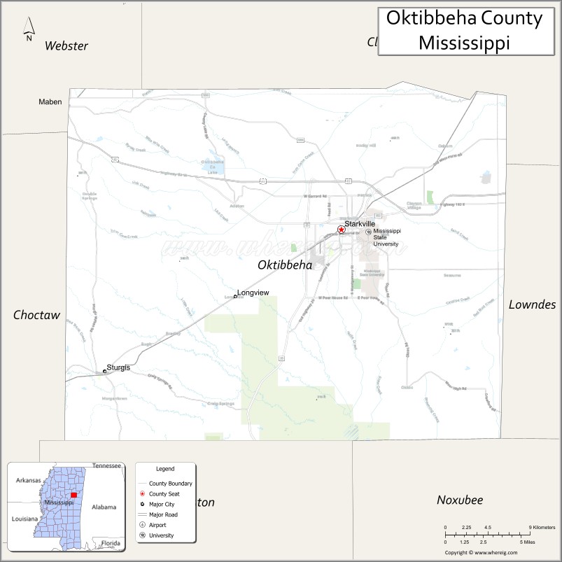
About Oktibbeha County Map, Mississippi: The map showing the county boundary, county seat, major cities, highways, water bodies and neighbouring counties.
Other Mississippi Maps & Info
Oktibbeha County, Mississippi
Oktibbeha County is a county located in the U.S. state of Mississippi. It's county seat is Starkville. As per 2020 census, the population of Oktibbeha County is 51842 people and population density is square miles. According to the United States Census Bureau, the county has a total area of 458 sq mi (1,186 km2). Oktibbeha County was established on 1833.
Oktibbeha County Facts
| Continent | North America |
| Country | United States |
| State | Mississippi |
| County Seat | Starkville |
| Largest City/Town | Starkville |
| Established | 1833 |
| Total Area | 462 sq mi (1,197 sq km) |
| Land Area | 458 sq mi (1,186 sq km) |
| Water Area | 4 sq mi (11 sq km) |
| Population | 49,587 (Census 2020) |
| Population Density | 108.3 people per sq mi |
| Time Zone | Central Time Zone |
| Major Highways | U.S. Route 82, Mississippi Highway 12, Mississippi Highway 25 |
| Major Rivers | Noxubee River, Tombigbee River nearby watershed |
| Neighboring Counties | Clay County, Lowndes County, Noxubee County, Winston County, Webster County |
| Famous For | Mississippi State University, college sports, and research innovation |
| Top Attractions | Mississippi State University, Davis Wade Stadium, and Noxubee National Wildlife Refuge nearby region |
| Official Website | Official Website |
About Oktibbeha County, Mississippi
Oktibbeha County is located in northeastern Mississippi and was established in 1833. The county seat and largest city is Starkville, home to Mississippi State University. Oktibbeha County is known for higher education, Southeastern Conference athletics, agricultural research, technology innovation, and vibrant college-town culture.
Cities and Towns in Oktibbeha County, Mississippi
| City/Town | Population (Census 2020) | Latitude & Longitude |
|---|---|---|
| Starkville (county seat) | 25,444 | 33.4504°N, 88.8184°W |
| Sturgis | 189 | 33.3462°N, 89.0459°W |
| Maben nearby region | 800 | 33.5437°N, 89.0848°W |
| Longview nearby region | 600 | 33.4842°N, 88.7073°W |
| Adaton nearby region | 1,200 | 33.4985°N, 88.7091°W |
Golf Courses in Oktibbeha County, Mississippi
| Golf Course | Location | Latitude & Longitude |
|---|---|---|
| Mossy Oak Golf Club | West Point nearby region | 33.6142°N, 88.6748°W |
| Mississippi State University Golf Course | Starkville | 33.4695°N, 88.7861°W |
| Old Waverly Golf Club nearby region | West Point region | 33.6301°N, 88.6543°W |
What Are the Major Roads and Highways in Oktibbeha County
Major highways provide important access to Starkville and Mississippi State University.
- U.S. Route 82 - major east-west transportation corridor across northern Mississippi
- Mississippi Highway 12 - key route connecting Starkville with surrounding communities
- Mississippi Highway 25 - regional north-south connector linking central and northeastern Mississippi
What are the Neighboring Counties of Oktibbeha County
- Clay County (north)
- Lowndes County (east)
- Noxubee County (south)
- Winston County (west)
- Webster County (northwest)
What Are the Top Attractions in Oktibbeha County
The county offers college sports, educational attractions, nature recreation, and cultural events.
- Mississippi State University - major research university known for academics, athletics, and agricultural innovation
- Davis Wade Stadium - home of Mississippi State Bulldogs football and one of the oldest college stadiums in the South
- Noxubee National Wildlife Refuge Nearby Region - wildlife viewing, hiking, fishing, and birdwatching destination
- Cotton District in Starkville - entertainment district with restaurants, nightlife, and shopping
- Mississippi State University Museums and Galleries - cultural exhibits, art collections, and educational attractions
- Humphrey Coliseum - basketball arena and event venue for university athletics and concerts
- Starkville Community Theatre and Arts Events - local performing arts and cultural programming
- University Golf Course - recreational golf facility associated with Mississippi State University
- Scenic Black Prairie Landscapes - rolling countryside and agricultural scenery throughout the county
- Annual Bulldog Bash and University Festivals - major events celebrating music, sports, and college culture
Distance from Oktibbeha County to Nearby Cities
The following distances are measured by road (driving).
- Starkville to Columbus, Mississippi - 25 mi (40 km)
- Starkville to Tupelo, Mississippi - 70 mi (113 km)
- Starkville to Tuscaloosa, Alabama - 78 mi (126 km)
- Starkville to Birmingham, Alabama - 138 mi (222 km)
- Starkville to Jackson, Mississippi - 124 mi (200 km)
- Starkville to Memphis, Tennessee - 170 mi (274 km)
- Starkville to Huntsville, Alabama - 165 mi (266 km)
- Starkville to Nashville, Tennessee - 259 mi (417 km)
- Starkville to Atlanta, Georgia - 254 mi (409 km)
- Starkville to New Orleans, Louisiana - 278 mi (447 km)
- Starkville to Dallas, Texas - 510 mi (821 km)
- Starkville to Houston, Texas - 470 mi (756 km)
FAQs about Oktibbeha County
Oktibbeha County is located in northeastern Mississippi.
Oktibbeha County had a population of 49,587 according to Census 2020 data.
Oktibbeha County is known for Mississippi State University, college sports, and research innovation.
The county is served by U.S. Route 82, Mississippi Highway 12, and Mississippi Highway 25.
Yes, Oktibbeha County has golf facilities including the Mississippi State University Golf Course and nearby championship golf clubs.
References
- QuickFacts - U.S. Census Bureau
- United States Census Bureau
- Official County Website
- Mississippi State University
- Noxubee National Wildlife Refuge
- Adams County Map
- Alcorn County Map
- Amite County Map
- Attala County Map
- Benton County Map
- Bolivar County Map
- Calhoun County Map
- Carroll County Map
- Chickasaw County Map
- Choctaw County Map
- Claiborne County Map
- Clarke County Map
- Clay County Map
- Coahoma County Map
- Copiah County Map
- Covington County Map
- DeSoto County Map
- Forrest County Map
- Franklin County Map
- George County Map
- Greene County Map
- Grenada County Map
- Hancock County Map
- Harrison County Map
- Hinds County Map
- Holmes County Map
- Humphreys County Map
- Issaquena County Map
- Itawamba County Map
- Jackson County Map
- Jasper County Map
- Jefferson County Map
- Jefferson Davis County Map
- Jones County Map
- Kemper County Map
- Lafayette County Map
- Lamar County Map
- Lauderdale County Map
- Lawrence County Map
- Leake County Map
- Lee County Map
- Leflore County Map
- Lincoln County Map
- Lowndes County Map
- Madison County Map
- Marion County Map
- Marshall County Map
- Monroe County Map
- Montgomery County Map
- Neshoba County Map
- Newton County Map
- Noxubee County Map
- Oktibbeha County Map
- Panola County Map
- Pearl River County Map
- Perry County Map
- Pike County Map
- Pontotoc County Map
- Prentiss County Map
- Quitman County Map
- Rankin County Map
- Scott County Map
- Sharkey County Map
- Simpson County Map
- Smith County Map
- Stone County Map
- Sunflower County Map
- Tallahatchie County Map
- Tate County Map
- Tippah County Map
- Tishomingo County Map
- Tunica County Map
- Union County Map
- Walthall County Map
- Warren County Map
- Washington County Map
- Wayne County Map
- Webster County Map
- Wilkinson County Map
- Winston County Map
- Yalobusha County Map
- Yazoo County Map
- Alabama Counties
- Alaska boroughs
- Arizona Counties
- Arkansas Counties
- California County Map
- Colorado Counties
- Connecticut Counties
- Delaware Counties
- Florida County Map
- Georgia County Map
- Hawaii Counties
- Idaho Counties
- Illinois Counties
- Indiana Counties
- Iowa Counties
- Kansas Counties
- Kentucky Counties
- Louisiana Counties
- Maine Counties
- Maryland Counties
- Massachusetts Counties
- Michigan County Map
- Minnesota Counties
- Mississippi Counties
- Missouri Counties
- Montana Counties
- Nebraska Counties
- Nevada Counties
- New York Counties
- New Hampshire Counties
- New Jersey Counties
- New Mexico Counties
- North Carolina Counties
- North Dakota Counties
- Ohio County Map
- Oklahoma Counties
- Oregon Counties
- Pennsylvania Counties
- Rhode Island Counties
- South Carolina Counties
- South Dakota Counties
- Map of Tennessee
- Texas County Map
- Utah Counties
- Vermont Counties
- Virginia Counties
- Washington Counties
- West Virginia Counties
- Wisconsin Counties
- Wyoming Counties