Written and Fact-checked by Whereig Editors, Reviewed by Mukesh Kumar| Last Updated On: May 12, 2026
Map of DeSoto County - DeSoto County is a county located in the U.S. state of Mississippi. DeSoto County Map showing cities, highways, important places and water bodies. Get Where is DeSoto County located in the map, major cities in DeSoto county, population, areas, and places of interest.
Map of DeSoto County, Mississippi
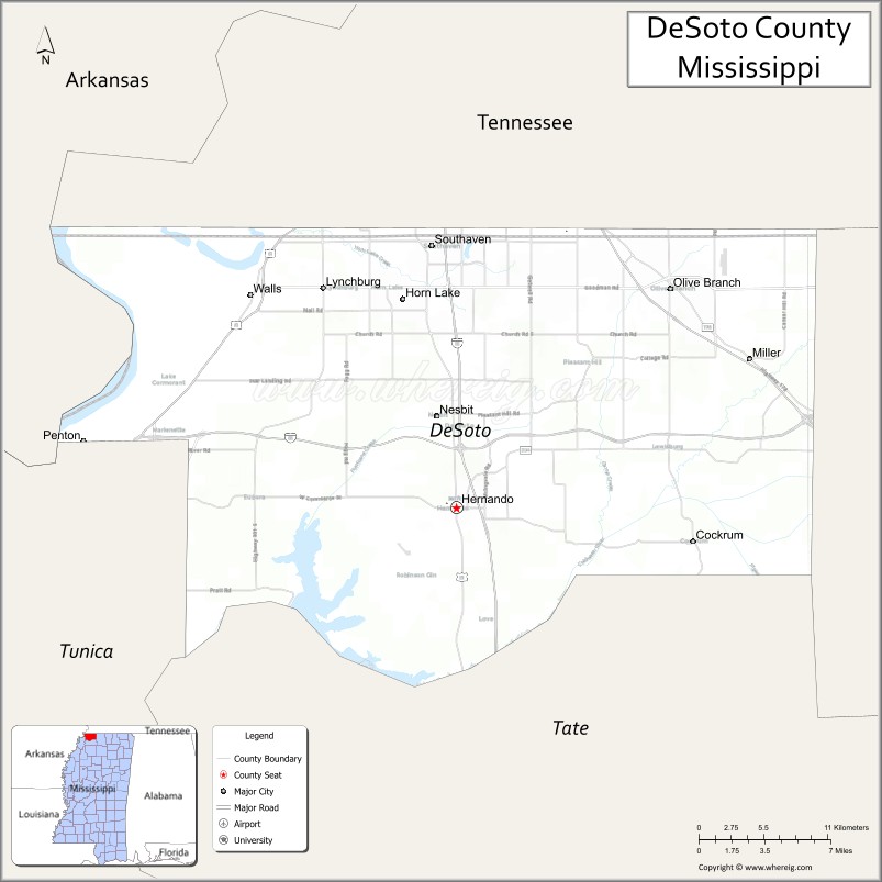
About DeSoto County Map, Mississippi: The map showing the county boundary, county seat, major cities, highways, water bodies and neighbouring counties.
Other Mississippi Maps & Info
DeSoto County, Mississippi
DeSoto County is a county located in the U.S. state of Mississippi. It's county seat is Hernando. As per 2020 census, the population of DeSoto County is 188633 people and population density is square miles. According to the United States Census Bureau, the county has a total area of 478 sq mi (1,238 km2). DeSoto County was established on 1836.
DeSoto County Facts
| Continent | North America |
| Country | United States |
| State | Mississippi |
| County Seat | Hernando |
| Largest City/Town | Southaven |
| Established | 1836 |
| Total Area | 497 sq mi (1,287 sq km) |
| Land Area | 476 sq mi (1,233 sq km) |
| Water Area | 21 sq mi (54 sq km) |
| Population | 185,314 (Census 2020) |
| Population Density | 389.3 people per sq mi |
| Time Zone | Central Time Zone |
| Major Highways | Interstate 55, Interstate 69, U.S. Route 51 |
| Major Rivers | Mississippi River, Coldwater River |
| Neighboring Counties | Tate County, Tunica County, Marshall County, Shelby County (Tennessee), Crittenden County (Arkansas) |
| Famous For | Rapid suburban growth, Memphis metropolitan area, and entertainment venues |
| Top Attractions | Landers Center, Tanger Outlets Southaven, and Hernando Historic Square |
| Official Website | Official Website |
About DeSoto County, Mississippi
DeSoto County is located in northwestern Mississippi along the Tennessee border and was established in 1836. The county seat is Hernando, while Southaven is the largest city. As part of the Memphis metropolitan area, DeSoto County is one of the fastest-growing counties in Mississippi and is known for shopping, entertainment, suburban communities, and strong economic development.
Cities and Towns in DeSoto County, Mississippi
| City/Town | Population (Census 2020) | Latitude & Longitude |
|---|---|---|
| Southaven | 54,648 | 34.9889°N, 90.0126°W |
| Olive Branch | 39,711 | 34.9618°N, 89.8295°W |
| Hernando (county seat) | 17,138 | 34.8230°N, 89.9937°W |
| Horn Lake | 26,736 | 34.9556°N, 90.0348°W |
| Walls | 1,274 | 34.9620°N, 90.1462°W |
| Lake Cormorant nearby region | 1,500 | 34.9156°N, 90.1601°W |
Golf Courses in DeSoto County, Mississippi
| Golf Course | Location | Latitude & Longitude |
|---|---|---|
| Wedgewood Golf Club | Olive Branch | 34.9624°N, 89.8269°W |
| Cherokee Valley Golf Club | Olive Branch | 34.9721°N, 89.8420°W |
| North Creek Golf Club | Southaven | 34.9790°N, 90.0184°W |
What Are the Major Roads and Highways in DeSoto County, Mississippi
Major highways make DeSoto County a major transportation hub in the Memphis metropolitan region.
- Interstate 55 - major north-south interstate connecting Memphis, Jackson, and New Orleans
- Interstate 69 - regional interstate corridor serving northern Mississippi and the Mid-South
- U.S. Route 51 - historic highway running parallel to Interstate 55
What are the Neighboring Counties of DeSoto County
- Tate County (south)
- Marshall County (east)
- Tunica County (west)
- Shelby County, Tennessee (north)
- Crittenden County, Arkansas (northwest)
What Are the Top Attractions in DeSoto County, Mississippi
The county offers shopping, entertainment, parks, and family-friendly attractions.
- Landers Center - major entertainment venue hosting concerts, sports, and community events
- Tanger Outlets Southaven - popular shopping destination with national retail brands
- Hernando Historic Square - charming downtown district with restaurants, boutiques, and historic buildings
- Snowden Grove Park - large recreation complex with sports facilities, playgrounds, and walking trails
- BankPlus Amphitheater at Snowden Grove - outdoor concert venue attracting national performers
- DeSoto County Museum - exhibits showcasing regional history and cultural heritage
- Arkabutla Lake Nearby Region - boating, fishing, camping, and hiking opportunities
- Southaven Towne Center - shopping and dining area in the Memphis suburban corridor
- Olive Branch City Park - recreation area with trails, sports fields, and community events
- Mississippi River Scenic Areas - nearby river landscapes ideal for sightseeing and photography
Distance from DeSoto County to Nearby Cities
The following distances are measured by road (driving).
- Hernando to Memphis, Tennessee - 26 mi (42 km)
- Hernando to Oxford, Mississippi - 69 mi (111 km)
- Hernando to Tunica Resorts, Mississippi - 33 mi (53 km)
- Hernando to Jackson, Mississippi - 184 mi (296 km)
- Hernando to Tupelo, Mississippi - 108 mi (174 km)
- Hernando to Little Rock, Arkansas - 149 mi (240 km)
- Hernando to Nashville, Tennessee - 224 mi (360 km)
- Hernando to Birmingham, Alabama - 236 mi (380 km)
- Hernando to St. Louis, Missouri - 290 mi (467 km)
- Hernando to New Orleans, Louisiana - 379 mi (610 km)
- Hernando to Dallas, Texas - 438 mi (705 km)
- Hernando to Atlanta, Georgia - 383 mi (616 km)
FAQs about DeSoto County
DeSoto County is located in northwestern Mississippi along the Tennessee border.
DeSoto County had a population of 185,314 according to Census 2020 data.
DeSoto County is known for rapid suburban growth, the Memphis metropolitan area, and entertainment venues.
The county is served by Interstate 55, Interstate 69, and U.S. Route 51.
Yes, DeSoto County has several golf facilities including Wedgewood Golf Club, Cherokee Valley Golf Club, and North Creek Golf Club.
References
- QuickFacts - U.S. Census Bureau
- United States Census Bureau
- Official County Website
- Tanger Outlets Southaven
- Landers Center
- Adams County Map
- Alcorn County Map
- Amite County Map
- Attala County Map
- Benton County Map
- Bolivar County Map
- Calhoun County Map
- Carroll County Map
- Chickasaw County Map
- Choctaw County Map
- Claiborne County Map
- Clarke County Map
- Clay County Map
- Coahoma County Map
- Copiah County Map
- Covington County Map
- DeSoto County Map
- Forrest County Map
- Franklin County Map
- George County Map
- Greene County Map
- Grenada County Map
- Hancock County Map
- Harrison County Map
- Hinds County Map
- Holmes County Map
- Humphreys County Map
- Issaquena County Map
- Itawamba County Map
- Jackson County Map
- Jasper County Map
- Jefferson County Map
- Jefferson Davis County Map
- Jones County Map
- Kemper County Map
- Lafayette County Map
- Lamar County Map
- Lauderdale County Map
- Lawrence County Map
- Leake County Map
- Lee County Map
- Leflore County Map
- Lincoln County Map
- Lowndes County Map
- Madison County Map
- Marion County Map
- Marshall County Map
- Monroe County Map
- Montgomery County Map
- Neshoba County Map
- Newton County Map
- Noxubee County Map
- Oktibbeha County Map
- Panola County Map
- Pearl River County Map
- Perry County Map
- Pike County Map
- Pontotoc County Map
- Prentiss County Map
- Quitman County Map
- Rankin County Map
- Scott County Map
- Sharkey County Map
- Simpson County Map
- Smith County Map
- Stone County Map
- Sunflower County Map
- Tallahatchie County Map
- Tate County Map
- Tippah County Map
- Tishomingo County Map
- Tunica County Map
- Union County Map
- Walthall County Map
- Warren County Map
- Washington County Map
- Wayne County Map
- Webster County Map
- Wilkinson County Map
- Winston County Map
- Yalobusha County Map
- Yazoo County Map
- Alabama Counties
- Alaska boroughs
- Arizona Counties
- Arkansas Counties
- California County Map
- Colorado Counties
- Connecticut Counties
- Delaware Counties
- Florida County Map
- Georgia County Map
- Hawaii Counties
- Idaho Counties
- Illinois Counties
- Indiana Counties
- Iowa Counties
- Kansas Counties
- Kentucky Counties
- Louisiana Counties
- Maine Counties
- Maryland Counties
- Massachusetts Counties
- Michigan County Map
- Minnesota Counties
- Mississippi Counties
- Missouri Counties
- Montana Counties
- Nebraska Counties
- Nevada Counties
- New York Counties
- New Hampshire Counties
- New Jersey Counties
- New Mexico Counties
- North Carolina Counties
- North Dakota Counties
- Ohio County Map
- Oklahoma Counties
- Oregon Counties
- Pennsylvania Counties
- Rhode Island Counties
- South Carolina Counties
- South Dakota Counties
- Map of Tennessee
- Texas County Map
- Utah Counties
- Vermont Counties
- Virginia Counties
- Washington Counties
- West Virginia Counties
- Wisconsin Counties
- Wyoming Counties