Written and Fact-checked by Whereig Editors, Reviewed by Mukesh Kumar| Last Updated On: May 12, 2026
Map of Tippah County - Tippah County is a county located in the U.S. state of Mississippi. Tippah County Map showing cities, highways, important places and water bodies. Get Where is Tippah County located in the map, major cities in Tippah county, population, areas, and places of interest.
Map of Tippah County, Mississippi
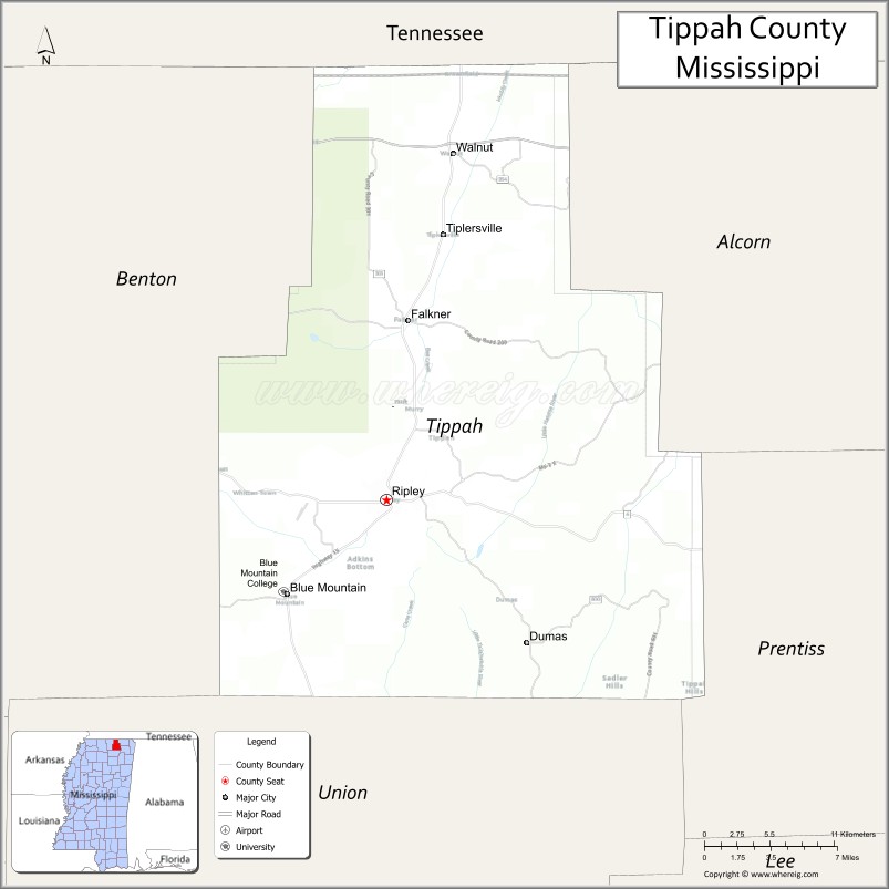
About Tippah County Map, Mississippi: The map showing the county boundary, county seat, major cities, highways, water bodies and neighbouring counties.
Other Mississippi Maps & Info
Tippah County, Mississippi
Tippah County is a county located in the U.S. state of Mississippi. It's county seat is Ripley. As per 2020 census, the population of Tippah County is 21635 people and population density is square miles. According to the United States Census Bureau, the county has a total area of 458 sq mi (1,186 km2). Tippah County was established on 1836.
Tippah County Facts
| Continent | North America |
| Country | United States |
| State | Mississippi |
| County Seat | Ripley |
| Largest City/Town | Ripley |
| Established | 1836 |
| Total Area | 460 sq mi (1,191 sq km) |
| Land Area | 458 sq mi (1,186 sq km) |
| Water Area | 2 sq mi (5 sq km) |
| Population | 21,815 (Census 2020) |
| Population Density | 48 people per sq mi |
| Time Zone | Central Time Zone (CST/CDT) |
| Major Highways | U.S. Route 45, Mississippi Highway 2, Mississippi Highway 4, Mississippi Highway 15 |
| Major Rivers | Tippah River, Hatchie River |
| Neighboring Counties | Benton County, Alcorn County, Prentiss County, Union County, Hardeman County (TN), McNairy County (TN) |
| Famous For | Historic Ripley, Tippah County Fair, and scenic North Mississippi landscapes |
| Top Attractions | Tippah County Fairgrounds, Ripley Historic District, Tippah River recreation areas, and First Monday Trade Day |
| Official Website | Official Website |
About Tippah County, Mississippi
Tippah County is located in northeastern Mississippi in the southern United States and was established in 1836. The county seat and largest city is Ripley. The county is known for its rolling hills, agricultural heritage, local festivals, and scenic countryside near the Tennessee border.
Cities and Towns in Tippah County, Mississippi
| City/Town | Population (Census 2020) | Latitude & Longitude |
|---|---|---|
| Ripley (county seat) | 5,377 | 34.7295°N, 88.9506°W |
| Blue Mountain | 920 | 34.6745°N, 89.0284°W |
| Walnut | 673 | 34.9467°N, 88.9140°W |
| Dumas | 470 | 34.6451°N, 88.8412°W |
| Falkner | 514 | 34.8403°N, 88.9382°W |
| Chalybeate (CDP) | 615 | 34.7725°N, 89.0013°W |
| Burton (CDP) | 278 | 34.8821°N, 88.8845°W |
Golf Courses in Tippah County, Mississippi
| Golf Course | Location | Latitude & Longitude |
|---|---|---|
| Hillcrest Country Club | Ripley | 34.7428°N, 88.9492°W |
| Tippah County Golf and Recreation Club | Blue Mountain | 34.6762°N, 89.0328°W |
What Are the Major Roads and Highways in Tippah County, Mississippi
Major highways connect the county to nearby North Mississippi communities and Tennessee.
- U.S. Route 45 - major north-south highway connecting Ripley with Corinth and Tupelo
- Mississippi Highway 2 - east-west route near the Tennessee border serving rural communities
- Mississippi Highway 4 - connects Ripley with northern Mississippi towns
- Mississippi Highway 15 - regional highway linking the county with New Albany and Booneville
What are the Neighboring Counties of Tippah County
- Hardeman County, Tennessee (northwest)
- McNairy County, Tennessee (northeast)
- Alcorn County (east)
- Prentiss County (southeast)
- Union County (south)
- Benton County (west)
What Are the Top Attractions in Tippah County, Mississippi
The county offers a mix of historic, recreational, and cultural attractions.
- Tippah County Fairgrounds - site of the annual Tippah County Fair and community events
- Ripley Historic District - historic downtown area with preserved architecture and local businesses
- First Monday Trade Day - popular flea market and shopping tradition in Ripley
- Tippah River - scenic river known for fishing and outdoor recreation
- Blue Mountain College Area - historic educational community in Blue Mountain
- Hillcrest Country Club - local golf and recreation destination
- Walnut Community Park - public recreation area with sports and picnic facilities
- Tippah County Courthouse - historic courthouse located in Ripley
- North Mississippi Hills Scenic Drives - countryside routes featuring rolling hills and forests
- Falkner Historic Area - quiet rural community known for traditional Mississippi culture
Distance from Tippah County to Nearby Cities
The following distances are measured by road (driving).
- Ripley to Tupelo (Lee County), Mississippi - 50 mi (80 km)
- Ripley to Corinth (Alcorn County), Mississippi - 32 mi (51 km)
- Ripley to New Albany (Union County), Mississippi - 31 mi (50 km)
- Ripley to Booneville (Prentiss County), Mississippi - 28 mi (45 km)
- Ripley to Oxford (Lafayette County), Mississippi - 51 mi (82 km)
- Ripley to Memphis (Shelby County), Tennessee - 93 mi (150 km)
- Ripley to Jackson (Madison County), Tennessee - 92 mi (148 km)
- Ripley to Holly Springs (Marshall County), Mississippi - 44 mi (71 km)
- Ripley to Blue Mountain (Tippah County), Mississippi - 8 mi (13 km)
- Ripley to Walnut (Tippah County), Mississippi - 16 mi (26 km)
- Ripley to Falkner (Tippah County), Mississippi - 12 mi (19 km)
- Ripley to Pontotoc (Pontotoc County), Mississippi - 42 mi (68 km)
- Ripley to Savannah (Hardin County), Tennessee - 57 mi (92 km)
FAQs about Tippah County
Tippah County is located in northeastern Mississippi near the Tennessee border.
Tippah County had a population of 21,815 according to the 2020 United States Census.
Tippah County is known for its county fair, scenic landscapes, and historic Ripley community.
The county is served by U.S. Route 45, Mississippi Highway 2, Mississippi Highway 4, and Mississippi Highway 15.
Yes, Tippah County includes golf facilities such as Hillcrest Country Club and local recreation golf areas.
References
- QuickFacts - U.S. Census Bureau
- United States Census Bureau
- United States Geological Survey (USGS)
- National Geodetic Survey
- Official County Website
- Adams County Map
- Alcorn County Map
- Amite County Map
- Attala County Map
- Benton County Map
- Bolivar County Map
- Calhoun County Map
- Carroll County Map
- Chickasaw County Map
- Choctaw County Map
- Claiborne County Map
- Clarke County Map
- Clay County Map
- Coahoma County Map
- Copiah County Map
- Covington County Map
- DeSoto County Map
- Forrest County Map
- Franklin County Map
- George County Map
- Greene County Map
- Grenada County Map
- Hancock County Map
- Harrison County Map
- Hinds County Map
- Holmes County Map
- Humphreys County Map
- Issaquena County Map
- Itawamba County Map
- Jackson County Map
- Jasper County Map
- Jefferson County Map
- Jefferson Davis County Map
- Jones County Map
- Kemper County Map
- Lafayette County Map
- Lamar County Map
- Lauderdale County Map
- Lawrence County Map
- Leake County Map
- Lee County Map
- Leflore County Map
- Lincoln County Map
- Lowndes County Map
- Madison County Map
- Marion County Map
- Marshall County Map
- Monroe County Map
- Montgomery County Map
- Neshoba County Map
- Newton County Map
- Noxubee County Map
- Oktibbeha County Map
- Panola County Map
- Pearl River County Map
- Perry County Map
- Pike County Map
- Pontotoc County Map
- Prentiss County Map
- Quitman County Map
- Rankin County Map
- Scott County Map
- Sharkey County Map
- Simpson County Map
- Smith County Map
- Stone County Map
- Sunflower County Map
- Tallahatchie County Map
- Tate County Map
- Tippah County Map
- Tishomingo County Map
- Tunica County Map
- Union County Map
- Walthall County Map
- Warren County Map
- Washington County Map
- Wayne County Map
- Webster County Map
- Wilkinson County Map
- Winston County Map
- Yalobusha County Map
- Yazoo County Map
- Alabama Counties
- Alaska boroughs
- Arizona Counties
- Arkansas Counties
- California County Map
- Colorado Counties
- Connecticut Counties
- Delaware Counties
- Florida County Map
- Georgia County Map
- Hawaii Counties
- Idaho Counties
- Illinois Counties
- Indiana Counties
- Iowa Counties
- Kansas Counties
- Kentucky Counties
- Louisiana Counties
- Maine Counties
- Maryland Counties
- Massachusetts Counties
- Michigan County Map
- Minnesota Counties
- Mississippi Counties
- Missouri Counties
- Montana Counties
- Nebraska Counties
- Nevada Counties
- New York Counties
- New Hampshire Counties
- New Jersey Counties
- New Mexico Counties
- North Carolina Counties
- North Dakota Counties
- Ohio County Map
- Oklahoma Counties
- Oregon Counties
- Pennsylvania Counties
- Rhode Island Counties
- South Carolina Counties
- South Dakota Counties
- Map of Tennessee
- Texas County Map
- Utah Counties
- Vermont Counties
- Virginia Counties
- Washington Counties
- West Virginia Counties
- Wisconsin Counties
- Wyoming Counties