Written and Fact-checked by Whereig Editors, Reviewed by Mukesh Kumar| Last Updated On: May 12, 2026
Map of Washington County - Washington County is a county located in the U.S. state of Mississippi. Washington County Map showing cities, highways, important places and water bodies. Get Where is Washington County located in the map, major cities in Washington county, population, areas, and places of interest.
Map of Washington County, Mississippi
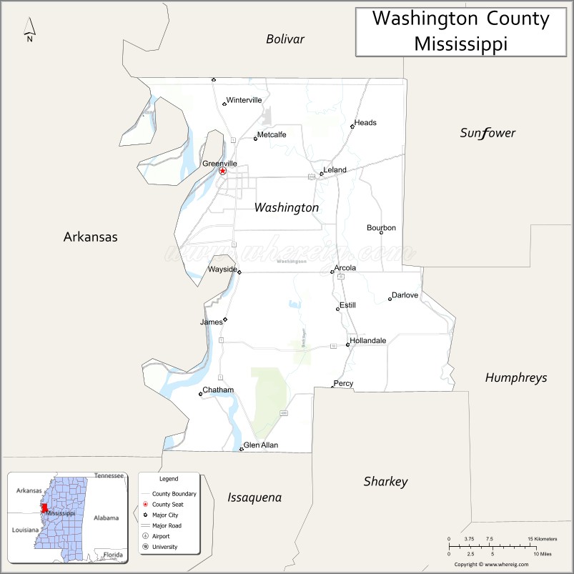
About Washington County Map, Mississippi: The map showing the county boundary, county seat, major cities, highways, water bodies and neighbouring counties.
Other Mississippi Maps & Info
Washington County, Mississippi
Washington County is a county located in the U.S. state of Mississippi. It's county seat is Greenville. As per 2020 census, the population of Washington County is 43687 people and population density is square miles. According to the United States Census Bureau, the county has a total area of 724 sq mi (1,875 km2). Washington County was established on 1827.
Washington County Facts
| Continent | North America |
| Country | United States |
| State | Mississippi |
| County Seat | Greenville |
| Largest City/Town | Greenville |
| Established | 1827 |
| Total Area | 761 sq mi (1,971 sq km) |
| Land Area | 725 sq mi (1,878 sq km) |
| Water Area | 36 sq mi (93 sq km) |
| Population | 44,922 (Census 2020) |
| Population Density | 62 people per sq mi |
| Time Zone | Central Time Zone (CST/CDT) |
| Major Highways | U.S. Route 82, U.S. Route 61, Mississippi Highway 1, Mississippi Highway 454 |
| Major Rivers | Mississippi River, Yazoo River, Deer Creek |
| Neighboring Counties | Bolivar County, Sunflower County, Sharkey County, Issaquena County, Chicot County (AR), East Carroll Parish (LA) |
| Famous For | Mississippi Delta blues, riverfront heritage, and agriculture |
| Top Attractions | Greenville History Museum, Mississippi River parks, Winterville Mounds, and Delta blues heritage sites |
| Official Website | Official Website |
About Washington County, Mississippi
Washington County is located in the Mississippi Delta region of western Mississippi in the southern United States and was established in 1827. The county seat and largest city is Greenville. The county is known for its Delta blues heritage, fertile agricultural land, Mississippi River history, and important cultural contributions to music and literature.
Cities and Towns in Washington County, Mississippi
| City/Town | Population (Census 2020) | Latitude & Longitude |
|---|---|---|
| Greenville (county seat) | 29,141 | 33.4089°N, 91.0612°W |
| Leland | 3,339 | 33.4051°N, 90.8970°W |
| Hollandale | 2,323 | 33.1682°N, 90.8537°W |
| Arcola | 361 | 33.2707°N, 90.8843°W |
| Metcalfe | 816 | 33.4521°N, 91.0006°W |
| Glen Allan (CDP) | 298 | 33.0204°N, 91.0245°W |
| Wayside (CDP) | 379 | 33.3278°N, 91.0324°W |
Golf Courses in Washington County, Mississippi
| Golf Course | Location | Latitude & Longitude |
|---|---|---|
| Greenville Golf and Country Club | Greenville | 33.4187°N, 91.0563°W |
| Delta Greens Golf Course | Leland | 33.4034°N, 90.8891°W |
What Are the Major Roads and Highways in Washington County, Mississippi
Major highways connect the county to nearby Delta communities and regional cities.
- U.S. Route 82 - major east-west highway linking Greenville with Greenwood and Arkansas
- U.S. Route 61 - north-south route following the Mississippi Delta corridor
- Mississippi Highway 1 - scenic highway running near the Mississippi River levees
- Mississippi Highway 454 - regional route serving rural Delta communities
What are the Neighboring Counties of Washington County
- Bolivar County (north)
- Sunflower County (east)
- Sharkey County (south)
- Issaquena County (southwest)
- Chicot County, Arkansas (west)
- East Carroll Parish, Louisiana (southwest)
What Are the Top Attractions in Washington County, Mississippi
The county offers a mix of Delta cultural landmarks and riverfront attractions.
- Winterville Mounds - archaeological site featuring Native American ceremonial mounds and museum exhibits
- Greenville History Museum - museum showcasing regional history, Delta culture, and river heritage
- Mississippi River Levee Parks - scenic parks and walking areas overlooking the Mississippi River
- Birthplace of Kermit the Frog Museum - small museum in Leland dedicated to Jim Henson and Kermit the Frog
- Greenville Cypress Preserve - nature preserve with trails and wildlife viewing opportunities
- Delta Blues Heritage Sites - historic locations connected to Mississippi blues musicians and culture
- Historic Downtown Greenville - district featuring historic architecture, restaurants, and local businesses
- Lake Ferguson Recreation Area - popular fishing and boating destination near Greenville
- 1927 Flood Museum - museum dedicated to the Great Mississippi Flood of 1927
- Hollandale Delta Community - traditional Delta town known for music and agricultural history
Distance from Washington County to Nearby Cities
The following distances are measured by road (driving).
- Greenville to Cleveland (Bolivar County), Mississippi - 43 mi (69 km)
- Greenville to Greenwood (Leflore County), Mississippi - 74 mi (119 km)
- Greenville to Indianola (Sunflower County), Mississippi - 37 mi (60 km)
- Greenville to Vicksburg (Warren County), Mississippi - 114 mi (183 km)
- Greenville to Clarksdale (Coahoma County), Mississippi - 88 mi (142 km)
- Greenville to Jackson (Hinds County), Mississippi - 147 mi (237 km)
- Greenville to Monroe (Ouachita Parish), Louisiana - 101 mi (163 km)
- Greenville to Leland (Washington County), Mississippi - 11 mi (18 km)
- Greenville to Hollandale (Washington County), Mississippi - 23 mi (37 km)
- Greenville to Memphis (Shelby County), Tennessee - 152 mi (245 km)
- Greenville to Little Rock (Pulaski County), Arkansas - 178 mi (286 km)
- Greenville to Natchez (Adams County), Mississippi - 159 mi (256 km)
- Greenville to Baton Rouge (East Baton Rouge Parish), Louisiana - 213 mi (343 km)
FAQs about Washington County
Washington County is located in the Mississippi Delta region of western Mississippi along the Mississippi River.
Washington County had a population of 44,922 according to the 2020 United States Census.
Washington County is known for Delta blues heritage, agriculture, Mississippi River history, and Winterville Mounds.
The county is served by U.S. Route 82, U.S. Route 61, Mississippi Highway 1, and Mississippi Highway 454.
Yes, Washington County includes golf facilities such as Greenville Golf and Country Club and Delta Greens Golf Course.
References
- QuickFacts - U.S. Census Bureau
- United States Census Bureau
- United States Geological Survey (USGS)
- National Geodetic Survey
- Official Website
- Adams County Map
- Alcorn County Map
- Amite County Map
- Attala County Map
- Benton County Map
- Bolivar County Map
- Calhoun County Map
- Carroll County Map
- Chickasaw County Map
- Choctaw County Map
- Claiborne County Map
- Clarke County Map
- Clay County Map
- Coahoma County Map
- Copiah County Map
- Covington County Map
- DeSoto County Map
- Forrest County Map
- Franklin County Map
- George County Map
- Greene County Map
- Grenada County Map
- Hancock County Map
- Harrison County Map
- Hinds County Map
- Holmes County Map
- Humphreys County Map
- Issaquena County Map
- Itawamba County Map
- Jackson County Map
- Jasper County Map
- Jefferson County Map
- Jefferson Davis County Map
- Jones County Map
- Kemper County Map
- Lafayette County Map
- Lamar County Map
- Lauderdale County Map
- Lawrence County Map
- Leake County Map
- Lee County Map
- Leflore County Map
- Lincoln County Map
- Lowndes County Map
- Madison County Map
- Marion County Map
- Marshall County Map
- Monroe County Map
- Montgomery County Map
- Neshoba County Map
- Newton County Map
- Noxubee County Map
- Oktibbeha County Map
- Panola County Map
- Pearl River County Map
- Perry County Map
- Pike County Map
- Pontotoc County Map
- Prentiss County Map
- Quitman County Map
- Rankin County Map
- Scott County Map
- Sharkey County Map
- Simpson County Map
- Smith County Map
- Stone County Map
- Sunflower County Map
- Tallahatchie County Map
- Tate County Map
- Tippah County Map
- Tishomingo County Map
- Tunica County Map
- Union County Map
- Walthall County Map
- Warren County Map
- Washington County Map
- Wayne County Map
- Webster County Map
- Wilkinson County Map
- Winston County Map
- Yalobusha County Map
- Yazoo County Map
- Alabama Counties
- Alaska boroughs
- Arizona Counties
- Arkansas Counties
- California County Map
- Colorado Counties
- Connecticut Counties
- Delaware Counties
- Florida County Map
- Georgia County Map
- Hawaii Counties
- Idaho Counties
- Illinois Counties
- Indiana Counties
- Iowa Counties
- Kansas Counties
- Kentucky Counties
- Louisiana Counties
- Maine Counties
- Maryland Counties
- Massachusetts Counties
- Michigan County Map
- Minnesota Counties
- Mississippi Counties
- Missouri Counties
- Montana Counties
- Nebraska Counties
- Nevada Counties
- New York Counties
- New Hampshire Counties
- New Jersey Counties
- New Mexico Counties
- North Carolina Counties
- North Dakota Counties
- Ohio County Map
- Oklahoma Counties
- Oregon Counties
- Pennsylvania Counties
- Rhode Island Counties
- South Carolina Counties
- South Dakota Counties
- Map of Tennessee
- Texas County Map
- Utah Counties
- Vermont Counties
- Virginia Counties
- Washington Counties
- West Virginia Counties
- Wisconsin Counties
- Wyoming Counties