Written and Fact-checked by Whereig Editors, Reviewed by Mukesh Kumar| Last Updated On: May 12, 2026
Map of Scott County - Scott County is a county located in the U.S. state of Mississippi. Scott County Map showing cities, highways, important places and water bodies. Get Where is Scott County located in the map, major cities in Scott county, population, areas, and places of interest.
Map of Scott County, Mississippi
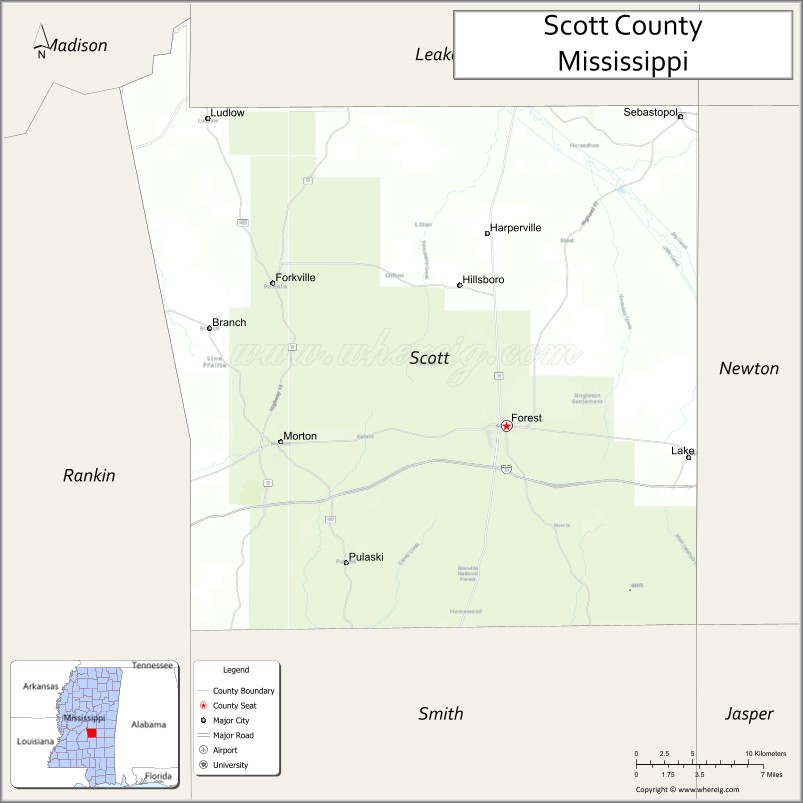
About Scott County Map, Mississippi: The map showing the county boundary, county seat, major cities, highways, water bodies and neighbouring counties.
Other Mississippi Maps & Info
Scott County, Mississippi
Scott County is a county located in the U.S. state of Mississippi. It's county seat is Forest. As per 2020 census, the population of Scott County is 27598 people and population density is square miles. According to the United States Census Bureau, the county has a total area of 609 sq mi (1,577 km2). Scott County was established on 1833.
Scott County Facts
| Continent | North America |
| Country | United States |
| State | Mississippi |
| County Seat | Forest |
| Largest City/Town | Forest |
| Established | 1833 |
| Total Area | 610 sq mi (1,580 sq km) |
| Land Area | 610 sq mi (1,580 sq km) |
| Water Area | 1 sq mi (3 sq km) |
| Population | 27,951 (Census 2020) |
| Population Density | 46 people per sq mi |
| Time Zone | Central Time Zone (CST/CDT) |
| Major Highways | Interstate 20, U.S. Route 80, Mississippi Highway 13, Mississippi Highway 21, Mississippi Highway 35 |
| Major Rivers | Strong River, Tallabogue Creek |
| Neighboring Counties | Leake County, Newton County, Smith County, Rankin County, Madison County, Neshoba County |
| Famous For | Bienville National Forest, historic Forest downtown, and outdoor recreation |
| Top Attractions | Bienville National Forest, Roosevelt State Park, Forest Historic District, and Golden Memorial State Park |
| Official Website | Official Website |
About Scott County, Mississippi
Scott County is located in central Mississippi in the southern United States and was established in 1833. The county seat and largest city is Forest. The county is known for its forests, lakes, outdoor recreation areas, and its position along major transportation routes through central Mississippi.
Cities and Towns in Scott County, Mississippi
| City/Town | Population (Census 2020) | Latitude & Longitude |
|---|---|---|
| Forest (county seat) | 5,430 | 32.3640°N, 89.4742°W |
| Morton | 3,462 | 32.3532°N, 89.6545°W |
| Lake | 397 | 32.3329°N, 89.3311°W |
| Sebastopol | 266 | 32.7715°N, 89.3492°W |
| Harperville | 258 | 32.6493°N, 89.4895°W |
| Hillsboro (CDP) | 478 | 32.4582°N, 89.5113°W |
| Ludlow (CDP) | 89 | 32.5378°N, 89.7301°W |
Golf Courses in Scott County, Mississippi
| Golf Course | Location | Latitude & Longitude |
|---|---|---|
| Forest Country Club | Forest | 32.3667°N, 89.4924°W |
| Roosevelt State Park Golf Area | Morton | 32.3602°N, 89.6540°W |
What Are the Major Roads and Highways in Scott County, Mississippi
Major highways connect the county to nearby cities and regions.
- Interstate 20 - major east-west interstate connecting Forest with Jackson and Meridian
- U.S. Route 80 - historic highway running parallel to Interstate 20 through the county
- Mississippi Highway 13 - connects Morton and Forest with nearby central Mississippi communities
- Mississippi Highway 21 - serves eastern Scott County and links to Newton County
- Mississippi Highway 35 - north-south route connecting Forest with Carthage and Raleigh
What are the Neighboring Counties of Scott County
- Leake County (north)
- Neshoba County (east)
- Newton County (southeast)
- Smith County (south)
- Rankin County (west)
- Madison County (northwest)
What Are the Top Attractions in Scott County, Mississippi
The county offers a mix of outdoor recreation and historic attractions.
- Bienville National Forest - large national forest with hiking, camping, and wildlife viewing areas
- Roosevelt State Park - state park with a lake, cabins, camping, fishing, and boating facilities
- Forest Historic District - historic downtown area featuring preserved buildings and local businesses
- Golden Memorial State Park - scenic recreation area with picnic spaces and trails
- Morton City Park - community recreation park with sports facilities and walking areas
- Bienville Pines Scenic Area - natural forested landscape popular for outdoor activities
- Strong River Area - scenic river corridor known for fishing and nature viewing
- Scott County Courthouse - historic courthouse located in downtown Forest
- Lake Community Area - small-town area surrounded by rural Mississippi landscapes
- Bienville National Forest ATV Trails - popular off-road riding destination in central Mississippi
Distance from Scott County to Nearby Cities
The following distances are measured by road (driving).
- Forest to Jackson (Hinds County), Mississippi - 46 mi (74 km)
- Forest to Meridian (Lauderdale County), Mississippi - 54 mi (87 km)
- Forest to Morton (Scott County), Mississippi - 13 mi (21 km)
- Forest to Carthage (Leake County), Mississippi - 27 mi (43 km)
- Forest to Philadelphia (Neshoba County), Mississippi - 36 mi (58 km)
- Forest to Raleigh (Smith County), Mississippi - 39 mi (63 km)
- Forest to Brandon (Rankin County), Mississippi - 39 mi (63 km)
- Forest to Vicksburg (Warren County), Mississippi - 91 mi (146 km)
- Forest to Hattiesburg (Forrest County), Mississippi - 88 mi (142 km)
- Forest to Starkville (Oktibbeha County), Mississippi - 93 mi (150 km)
- Forest to Tupelo (Lee County), Mississippi - 145 mi (233 km)
- Forest to Laurel (Jones County), Mississippi - 68 mi (109 km)
- Forest to Greenwood (Leflore County), Mississippi - 126 mi (203 km)
FAQs about Scott County
Scott County is located in central Mississippi between Jackson and Meridian.
Scott County had a population of 27,951 according to the 2020 United States Census.
Scott County is known for Bienville National Forest, Roosevelt State Park, and outdoor recreation opportunities.
The county is served by Interstate 20, U.S. Route 80, Mississippi Highway 13, and Mississippi Highway 35.
Yes, Scott County includes golf facilities such as Forest Country Club and golf recreation areas near Roosevelt State Park.
References
- QuickFacts - U.S. Census Bureau
- United States Census Bureau
- United States Geological Survey (USGS)
- National Geodetic Survey
- Official County Website
- Adams County Map
- Alcorn County Map
- Amite County Map
- Attala County Map
- Benton County Map
- Bolivar County Map
- Calhoun County Map
- Carroll County Map
- Chickasaw County Map
- Choctaw County Map
- Claiborne County Map
- Clarke County Map
- Clay County Map
- Coahoma County Map
- Copiah County Map
- Covington County Map
- DeSoto County Map
- Forrest County Map
- Franklin County Map
- George County Map
- Greene County Map
- Grenada County Map
- Hancock County Map
- Harrison County Map
- Hinds County Map
- Holmes County Map
- Humphreys County Map
- Issaquena County Map
- Itawamba County Map
- Jackson County Map
- Jasper County Map
- Jefferson County Map
- Jefferson Davis County Map
- Jones County Map
- Kemper County Map
- Lafayette County Map
- Lamar County Map
- Lauderdale County Map
- Lawrence County Map
- Leake County Map
- Lee County Map
- Leflore County Map
- Lincoln County Map
- Lowndes County Map
- Madison County Map
- Marion County Map
- Marshall County Map
- Monroe County Map
- Montgomery County Map
- Neshoba County Map
- Newton County Map
- Noxubee County Map
- Oktibbeha County Map
- Panola County Map
- Pearl River County Map
- Perry County Map
- Pike County Map
- Pontotoc County Map
- Prentiss County Map
- Quitman County Map
- Rankin County Map
- Scott County Map
- Sharkey County Map
- Simpson County Map
- Smith County Map
- Stone County Map
- Sunflower County Map
- Tallahatchie County Map
- Tate County Map
- Tippah County Map
- Tishomingo County Map
- Tunica County Map
- Union County Map
- Walthall County Map
- Warren County Map
- Washington County Map
- Wayne County Map
- Webster County Map
- Wilkinson County Map
- Winston County Map
- Yalobusha County Map
- Yazoo County Map
- Alabama Counties
- Alaska boroughs
- Arizona Counties
- Arkansas Counties
- California County Map
- Colorado Counties
- Connecticut Counties
- Delaware Counties
- Florida County Map
- Georgia County Map
- Hawaii Counties
- Idaho Counties
- Illinois Counties
- Indiana Counties
- Iowa Counties
- Kansas Counties
- Kentucky Counties
- Louisiana Counties
- Maine Counties
- Maryland Counties
- Massachusetts Counties
- Michigan County Map
- Minnesota Counties
- Mississippi Counties
- Missouri Counties
- Montana Counties
- Nebraska Counties
- Nevada Counties
- New York Counties
- New Hampshire Counties
- New Jersey Counties
- New Mexico Counties
- North Carolina Counties
- North Dakota Counties
- Ohio County Map
- Oklahoma Counties
- Oregon Counties
- Pennsylvania Counties
- Rhode Island Counties
- South Carolina Counties
- South Dakota Counties
- Map of Tennessee
- Texas County Map
- Utah Counties
- Vermont Counties
- Virginia Counties
- Washington Counties
- West Virginia Counties
- Wisconsin Counties
- Wyoming Counties