Written and Fact-checked by Whereig Editors, Reviewed by Mukesh Kumar| Last Updated On: May 12, 2026
Map of Adams County - Adams County is a county located in the U.S. state of Mississippi. Adams County Map showing cities, highways, important places and water bodies. Get Where is Adams County located in the map, major cities in Adams county, population, areas, and places of interest.
Map of Adams County, Mississippi
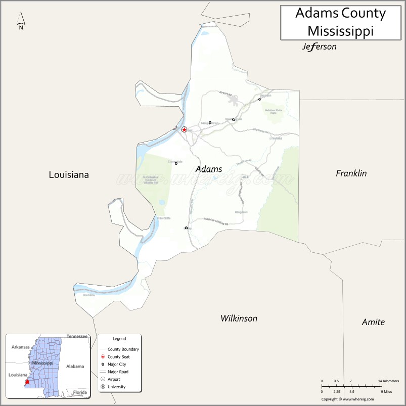
About Adams County Map, Mississippi: The map showing the county boundary, county seat, major cities, highways, water bodies and neighbouring counties.
Other Mississippi Maps & Info
Adams County, Mississippi
Adams County is a county located in the U.S. state of Mississippi. It's county seat is Natchez. As per 2020 census, the population of Adams County is 28742 people and population density is square miles. According to the United States Census Bureau, the county has a total area of 460 sq mi (1,191 km2). Adams County was established on 1799.
Adams County Facts
| Continent | North America |
| Country | United States |
| State | Mississippi |
| County Seat | Natchez |
| Largest City/Town | Natchez |
| Established | 1799 |
| Total Area | 487 sq mi (1,261 sq km) |
| Land Area | 460 sq mi (1,191 sq km) |
| Water Area | 27 sq mi (70 sq km) |
| Population | 29,538 (Census 2020) |
| Population Density | 64.2 people per sq mi |
| Time Zone | Central Time Zone |
| Major Highways | U.S. Route 61, U.S. Route 84, Mississippi Highway 553 |
| Major Rivers | Mississippi River |
| Neighboring Counties | Franklin County, Jefferson County, Wilkinson County, Concordia Parish (Louisiana), Catahoula Parish (Louisiana) |
| Famous For | Historic Natchez mansions, Mississippi River heritage, and antebellum architecture |
| Top Attractions | Natchez National Historical Park, Longwood Mansion, and Natchez Trace Parkway |
| Official Website | Official Website |
About Adams County, Mississippi
Adams County is located in southwestern Mississippi along the Mississippi River and was established in 1799 as one of the oldest counties in the state. The county seat and largest city is Natchez, a historic river city famous for antebellum mansions, Southern culture, and Mississippi River history. Adams County is known for tourism, historic preservation, and scenic riverfront landscapes.
Cities and Towns in Adams County, Mississippi
| City/Town | Population (Census 2020) | Latitude & Longitude |
|---|---|---|
| Natchez (county seat) | 14,520 | 31.5604°N, 91.4032°W |
| Washington | 51 | 31.5788°N, 91.2990°W |
Golf Courses in Adams County, Mississippi
| Golf Course | Location | Latitude & Longitude |
|---|---|---|
| Duncan Park Golf Course | Natchez | 31.5539°N, 91.3898°W |
| Beau Pré Country Club | Natchez | 31.5894°N, 91.3675°W |
What Are the Major Roads and Highways in Adams County, Mississippi
Major highways connect Adams County with Louisiana and central Mississippi.
- U.S. Route 61 - historic north-south highway following the Mississippi River corridor
- U.S. Route 84 - important east-west route connecting Mississippi and Louisiana
- Mississippi Highway 553 - scenic highway leading to Natchez Trace Parkway areas
Neighboring Counties and Parishes of Adams County
- Franklin County (east)
- Jefferson County (north)
- Wilkinson County (south)
- Concordia Parish, Louisiana (west)
- Catahoula Parish, Louisiana (northwest)
What Are the Top Attractions in Adams County, Mississippi
The county offers a rich mix of historical, cultural, and outdoor attractions.
- Natchez National Historical Park - historic sites preserving the cultural and architectural history of Natchez
- Longwood Mansion - famous unfinished antebellum mansion and one of Mississippi’s best-known landmarks
- Natchez Trace Parkway - scenic driving route with historical and recreational sites
- Rosalie Mansion and Gardens - restored historic estate overlooking the Mississippi River
- Stanton Hall - grand Greek Revival mansion offering guided tours and local history
- Downtown Natchez Historic District - local shops, restaurants, museums, and preserved architecture
- Mississippi River Scenic Overlooks - riverfront locations ideal for photography and sightseeing
- Grand Village of the Natchez Indians - archaeological and cultural heritage site
- Duncan Park - recreation area with trails, sports facilities, and golf amenities
- Annual Natchez Pilgrimage Tours - seasonal events showcasing historic homes and Southern heritage
Distance from Adams County to Nearby Cities
The following distances are measured by road (driving).
- Natchez to Baton Rouge, Louisiana - 91 mi (146 km)
- Natchez to Jackson, Mississippi - 105 mi (169 km)
- Natchez to Vicksburg, Mississippi - 72 mi (116 km)
- Natchez to Alexandria, Louisiana - 85 mi (137 km)
- Natchez to Monroe, Louisiana - 121 mi (195 km)
- Natchez to Hattiesburg, Mississippi - 153 mi (246 km)
- Natchez to New Orleans, Louisiana - 172 mi (277 km)
- Natchez to Gulfport, Mississippi - 196 mi (315 km)
- Natchez to Memphis, Tennessee - 306 mi (492 km)
- Natchez to Birmingham, Alabama - 309 mi (497 km)
- Natchez to Houston, Texas - 333 mi (536 km)
- Natchez to Atlanta, Georgia - 455 mi (732 km)
FAQs about Adams County
Adams County is located in southwestern Mississippi along the Mississippi River.
Adams County had a population of 29,538 according to Census 2020 data.
Adams County is known for historic Natchez mansions, antebellum architecture, and Mississippi River heritage.
The county is served by U.S. Route 61, U.S. Route 84, and Mississippi Highway 553.
Yes, Adams County has golf facilities including Duncan Park Golf Course and Beau Pré Country Club.
References
- QuickFacts - U.S. Census Bureau
- United States Census Bureau
- Natchez Trace Parkway - National Park Service
- Natchez National Historical Park
- Official County Website
- Adams County Map
- Alcorn County Map
- Amite County Map
- Attala County Map
- Benton County Map
- Bolivar County Map
- Calhoun County Map
- Carroll County Map
- Chickasaw County Map
- Choctaw County Map
- Claiborne County Map
- Clarke County Map
- Clay County Map
- Coahoma County Map
- Copiah County Map
- Covington County Map
- DeSoto County Map
- Forrest County Map
- Franklin County Map
- George County Map
- Greene County Map
- Grenada County Map
- Hancock County Map
- Harrison County Map
- Hinds County Map
- Holmes County Map
- Humphreys County Map
- Issaquena County Map
- Itawamba County Map
- Jackson County Map
- Jasper County Map
- Jefferson County Map
- Jefferson Davis County Map
- Jones County Map
- Kemper County Map
- Lafayette County Map
- Lamar County Map
- Lauderdale County Map
- Lawrence County Map
- Leake County Map
- Lee County Map
- Leflore County Map
- Lincoln County Map
- Lowndes County Map
- Madison County Map
- Marion County Map
- Marshall County Map
- Monroe County Map
- Montgomery County Map
- Neshoba County Map
- Newton County Map
- Noxubee County Map
- Oktibbeha County Map
- Panola County Map
- Pearl River County Map
- Perry County Map
- Pike County Map
- Pontotoc County Map
- Prentiss County Map
- Quitman County Map
- Rankin County Map
- Scott County Map
- Sharkey County Map
- Simpson County Map
- Smith County Map
- Stone County Map
- Sunflower County Map
- Tallahatchie County Map
- Tate County Map
- Tippah County Map
- Tishomingo County Map
- Tunica County Map
- Union County Map
- Walthall County Map
- Warren County Map
- Washington County Map
- Wayne County Map
- Webster County Map
- Wilkinson County Map
- Winston County Map
- Yalobusha County Map
- Yazoo County Map
- Alabama Counties
- Alaska boroughs
- Arizona Counties
- Arkansas Counties
- California County Map
- Colorado Counties
- Connecticut Counties
- Delaware Counties
- Florida County Map
- Georgia County Map
- Hawaii Counties
- Idaho Counties
- Illinois Counties
- Indiana Counties
- Iowa Counties
- Kansas Counties
- Kentucky Counties
- Louisiana Counties
- Maine Counties
- Maryland Counties
- Massachusetts Counties
- Michigan County Map
- Minnesota Counties
- Mississippi Counties
- Missouri Counties
- Montana Counties
- Nebraska Counties
- Nevada Counties
- New York Counties
- New Hampshire Counties
- New Jersey Counties
- New Mexico Counties
- North Carolina Counties
- North Dakota Counties
- Ohio County Map
- Oklahoma Counties
- Oregon Counties
- Pennsylvania Counties
- Rhode Island Counties
- South Carolina Counties
- South Dakota Counties
- Map of Tennessee
- Texas County Map
- Utah Counties
- Vermont Counties
- Virginia Counties
- Washington Counties
- West Virginia Counties
- Wisconsin Counties
- Wyoming Counties