Written and Fact-checked by Whereig Editors, Reviewed by Mukesh Kumar| Last Updated On: May 12, 2026
Map of Lamar County - Lamar County is a county located in the U.S. state of Mississippi. Lamar County Map showing cities, highways, important places and water bodies. Get Where is Lamar County located in the map, major cities in Lamar county, population, areas, and places of interest.
Map of Lamar County, Mississippi
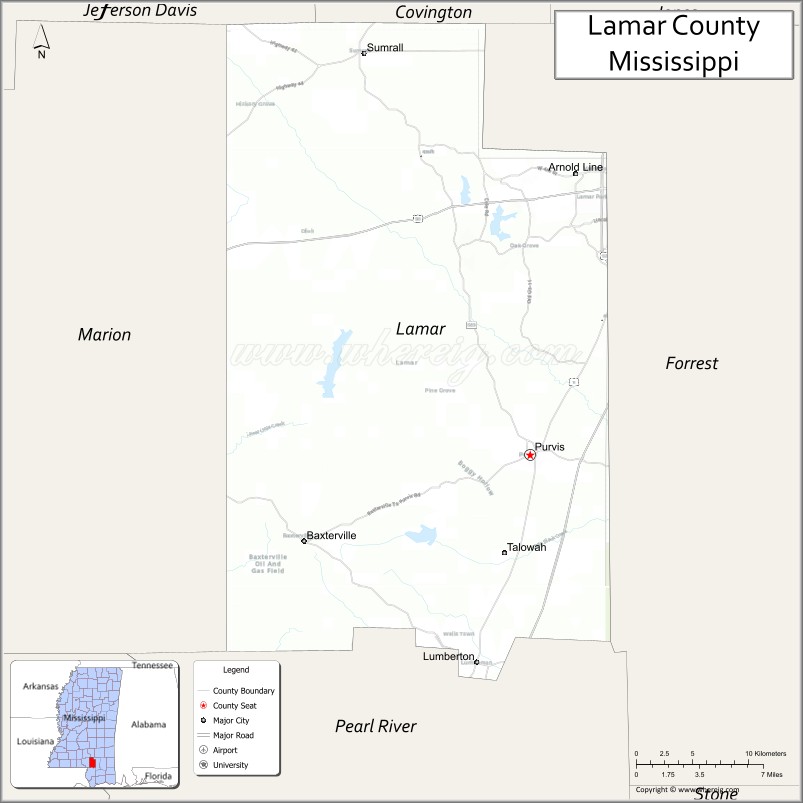
About Lamar County Map, Mississippi: The map showing the county boundary, county seat, major cities, highways, water bodies and neighbouring counties.
Other Mississippi Maps & Info
Lamar County, Mississippi
Lamar County is a county located in the U.S. state of Mississippi. It's county seat is Purvis. As per 2020 census, the population of Lamar County is 65353 people and population density is square miles. According to the United States Census Bureau, the county has a total area of 497 sq mi (1,287 km2). Lamar County was established on 1904.
Lamar County Facts
| Continent | North America |
| Country | United States |
| State | Mississippi |
| County Seat | Purvis |
| Largest City/Town | Hattiesburg (partly) |
| Established | 1904 |
| Total Area | 500 sq mi (1,295 sq km) |
| Land Area | 497 sq mi (1,287 sq km) |
| Water Area | 3 sq mi (8 sq km) |
| Population | 64,222 (Census 2020) |
| Population Density | 129.2 people per sq mi |
| Time Zone | Central Time Zone |
| Major Highways | U.S. Route 98, Interstate 59, Mississippi Highway 589 |
| Major Rivers | Leaf River, Black Creek |
| Neighboring Counties | Forrest County, Pearl River County, Marion County, Covington County, Perry County |
| Famous For | Hattiesburg metropolitan growth, Longleaf Trace, and outdoor recreation |
| Top Attractions | Longleaf Trace, Hattiesburg Zoo nearby region, and Okatoma Creek recreation |
| Official Website | Official Website |
About Lamar County, Mississippi
Lamar County is located in south-central Mississippi and was established in 1904. The county seat is Purvis, while part of Hattiesburg extends into the county and serves as the largest urban area. Lamar County is known for rapid suburban growth, outdoor recreation, educational institutions, and scenic pine forest landscapes.
Cities and Towns in Lamar County, Mississippi
| City/Town | Population (Census 2020) | Latitude & Longitude |
|---|---|---|
| Purvis (county seat) | 2,115 | 31.1438°N, 89.4098°W |
| Hattiesburg (partly in county) | 45,989 | 31.3271°N, 89.2903°W |
| Lumberton (partly) | 1,928 | 30.9891°N, 89.4520°W |
| Baxterville nearby region | 1,200 | 31.0066°N, 89.4467°W |
| Sumrall | 1,421 | 31.4177°N, 89.5367°W |
| Oak Grove nearby region | 8,000 | 31.3163°N, 89.3745°W |
Golf Courses in Lamar County, Mississippi
| Golf Course | Location | Latitude & Longitude |
|---|---|---|
| Canebrake Country Club | Hattiesburg area | 31.3356°N, 89.3732°W |
| Hattiesburg Country Club nearby region | Hattiesburg area | 31.3259°N, 89.3441°W |
| Timberton Golf Club nearby region | Hattiesburg metro area | 31.2897°N, 89.3476°W |
What Are the Major Roads and Highways in Lamar County
Major highways connect Lamar County with Gulf Coast communities and central Mississippi cities.
- U.S. Route 98 - major east-west corridor through southern Mississippi
- Interstate 59 - interstate highway linking New Orleans and Birmingham
- Mississippi Highway 589 - regional connector serving suburban Hattiesburg communities
What are the Neighboring Counties of Lamar County
- Covington County (north)
- Forrest County (east)
- Perry County (southeast)
- Pearl River County (southwest)
- Marion County (west)
What Are the Top Attractions in Lamar County
The county offers outdoor recreation, family attractions, and scenic South Mississippi landscapes.
- Longleaf Trace - popular recreational trail for biking, walking, and running through scenic pine forests
- Hattiesburg Zoo Nearby Region - family attraction featuring wildlife exhibits and educational programs
- Okatoma Creek Recreation Areas - canoeing, kayaking, tubing, and fishing opportunities
- Canebrake Golf Community - golf and residential recreation destination near Hattiesburg
- Purvis Historic District - small-town area featuring historic buildings and community events
- Black Creek Wilderness Areas - camping, hiking, and wildlife observation destinations
- Paul B. Johnson State Park Nearby Region - fishing, camping, and lake recreation opportunities
- Southern Miss Athletic and Cultural Events Nearby Region - regional sports and entertainment attractions
- Community Parks and Sports Facilities - recreation areas supporting family and youth activities
- Annual Festivals and Outdoor Events - celebrations highlighting South Mississippi culture and recreation
Distance from Lamar County to Nearby Cities
The following distances are measured by road (driving).
- Purvis to Hattiesburg, Mississippi - 12 mi (19 km)
- Purvis to Gulfport, Mississippi - 72 mi (116 km)
- Purvis to Biloxi, Mississippi - 79 mi (127 km)
- Purvis to Mobile, Alabama - 104 mi (167 km)
- Purvis to Jackson, Mississippi - 92 mi (148 km)
- Purvis to New Orleans, Louisiana - 106 mi (171 km)
- Purvis to Baton Rouge, Louisiana - 144 mi (232 km)
- Purvis to Birmingham, Alabama - 239 mi (385 km)
- Purvis to Atlanta, Georgia - 349 mi (562 km)
- Purvis to Memphis, Tennessee - 305 mi (491 km)
- Purvis to Houston, Texas - 374 mi (602 km)
- Purvis to Dallas, Texas - 505 mi (813 km)
FAQs about Lamar County
Lamar County is located in south-central Mississippi.
Lamar County had a population of 64,222 according to Census 2020 data.
Lamar County is known for Hattiesburg metropolitan growth, Longleaf Trace, and outdoor recreation.
The county is served by U.S. Route 98, Interstate 59, and Mississippi Highway 589.
Yes, Lamar County has golf facilities including Canebrake Country Club and Timberton Golf Club.
References
- QuickFacts - U.S. Census Bureau
- United States Census Bureau
- Official County Website
- Longleaf Trace
- Visit Mississippi
- Adams County Map
- Alcorn County Map
- Amite County Map
- Attala County Map
- Benton County Map
- Bolivar County Map
- Calhoun County Map
- Carroll County Map
- Chickasaw County Map
- Choctaw County Map
- Claiborne County Map
- Clarke County Map
- Clay County Map
- Coahoma County Map
- Copiah County Map
- Covington County Map
- DeSoto County Map
- Forrest County Map
- Franklin County Map
- George County Map
- Greene County Map
- Grenada County Map
- Hancock County Map
- Harrison County Map
- Hinds County Map
- Holmes County Map
- Humphreys County Map
- Issaquena County Map
- Itawamba County Map
- Jackson County Map
- Jasper County Map
- Jefferson County Map
- Jefferson Davis County Map
- Jones County Map
- Kemper County Map
- Lafayette County Map
- Lamar County Map
- Lauderdale County Map
- Lawrence County Map
- Leake County Map
- Lee County Map
- Leflore County Map
- Lincoln County Map
- Lowndes County Map
- Madison County Map
- Marion County Map
- Marshall County Map
- Monroe County Map
- Montgomery County Map
- Neshoba County Map
- Newton County Map
- Noxubee County Map
- Oktibbeha County Map
- Panola County Map
- Pearl River County Map
- Perry County Map
- Pike County Map
- Pontotoc County Map
- Prentiss County Map
- Quitman County Map
- Rankin County Map
- Scott County Map
- Sharkey County Map
- Simpson County Map
- Smith County Map
- Stone County Map
- Sunflower County Map
- Tallahatchie County Map
- Tate County Map
- Tippah County Map
- Tishomingo County Map
- Tunica County Map
- Union County Map
- Walthall County Map
- Warren County Map
- Washington County Map
- Wayne County Map
- Webster County Map
- Wilkinson County Map
- Winston County Map
- Yalobusha County Map
- Yazoo County Map
- Alabama Counties
- Alaska boroughs
- Arizona Counties
- Arkansas Counties
- California County Map
- Colorado Counties
- Connecticut Counties
- Delaware Counties
- Florida County Map
- Georgia County Map
- Hawaii Counties
- Idaho Counties
- Illinois Counties
- Indiana Counties
- Iowa Counties
- Kansas Counties
- Kentucky Counties
- Louisiana Counties
- Maine Counties
- Maryland Counties
- Massachusetts Counties
- Michigan County Map
- Minnesota Counties
- Mississippi Counties
- Missouri Counties
- Montana Counties
- Nebraska Counties
- Nevada Counties
- New York Counties
- New Hampshire Counties
- New Jersey Counties
- New Mexico Counties
- North Carolina Counties
- North Dakota Counties
- Ohio County Map
- Oklahoma Counties
- Oregon Counties
- Pennsylvania Counties
- Rhode Island Counties
- South Carolina Counties
- South Dakota Counties
- Map of Tennessee
- Texas County Map
- Utah Counties
- Vermont Counties
- Virginia Counties
- Washington Counties
- West Virginia Counties
- Wisconsin Counties
- Wyoming Counties