Written and Fact-checked by Whereig Editors, Reviewed by Mukesh Kumar| Last Updated On: May 12, 2026
Map of Humphreys County - Humphreys County is a county located in the U.S. state of Mississippi. Humphreys County Map showing cities, highways, important places and water bodies. Get Where is Humphreys County located in the map, major cities in Humphreys county, population, areas, and places of interest.
Map of Humphreys County, Mississippi
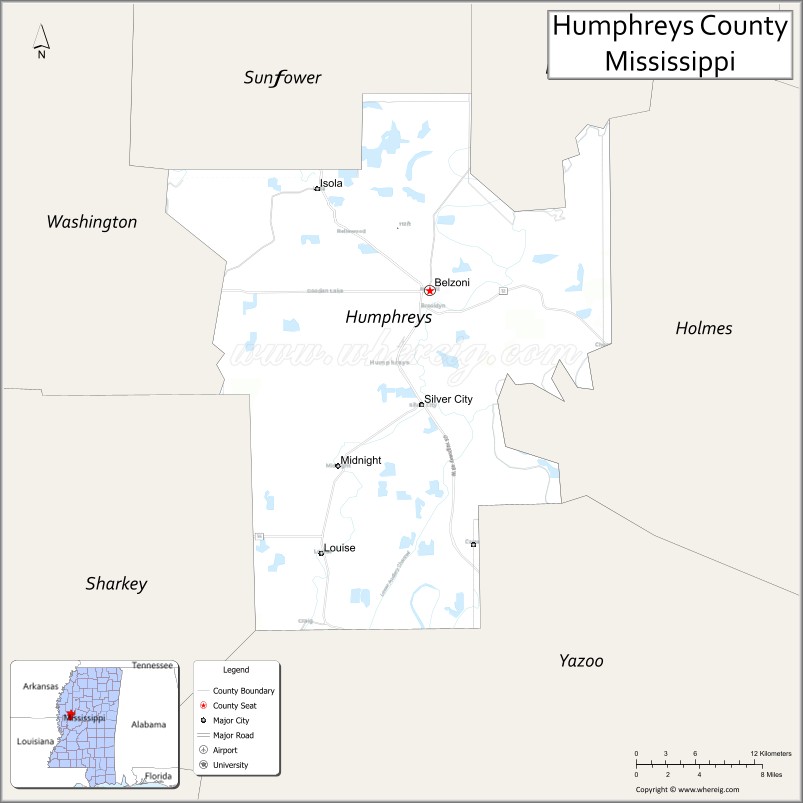
About Humphreys County Map, Mississippi: The map showing the county boundary, county seat, major cities, highways, water bodies and neighbouring counties.
Other Mississippi Maps & Info
Humphreys County, Mississippi
Humphreys County is a county located in the U.S. state of Mississippi. It's county seat is Belzoni. As per 2020 census, the population of Humphreys County is 7551 people and population density is square miles. According to the United States Census Bureau, the county has a total area of 418 sq mi (1,083 km2). Humphreys County was established on 1918.
Humphreys County Facts
| Continent | North America |
| Country | United States |
| State | Mississippi |
| County Seat | Belzoni |
| Largest City/Town | Belzoni |
| Established | 1918 |
| Total Area | 431 sq mi (1,116 sq km) |
| Land Area | 418 sq mi (1,083 sq km) |
| Water Area | 13 sq mi (34 sq km) |
| Population | 7,785 (Census 2020) |
| Population Density | 18.6 people per sq mi |
| Time Zone | Central Time Zone |
| Major Highways | U.S. Route 49W, Mississippi Highway 12, Mississippi Highway 7 |
| Major Rivers | Yazoo River, Sunflower River |
| Neighboring Counties | Holmes County, Leflore County, Sunflower County, Sharkey County, Washington County, Yazoo County |
| Famous For | Catfish farming, Mississippi Delta culture, and blues heritage |
| Top Attractions | Catfish Museum, Belzoni Historic District, and Delta scenic drives |
| Official Website | Official Website |
About Humphreys County, Mississippi
Humphreys County is located in the Mississippi Delta region and was established in 1918. The county seat and largest city is Belzoni, widely known as the “Catfish Capital of the World.” The county is famous for catfish farming, Delta agriculture, blues culture, and scenic rural landscapes.
Cities and Towns in Humphreys County, Mississippi
| City/Town | Population (Census 2020) | Latitude & Longitude |
|---|---|---|
| Belzoni (county seat) | 1,862 | 33.1840°N, 90.4893°W |
| Isola | 410 | 33.2629°N, 90.5937°W |
| Louise | 977 | 33.1171°N, 90.5251°W |
| Silver City | 221 | 33.0710°N, 90.5331°W |
| Midnight nearby region | 800 | 33.1406°N, 90.5926°W |
Golf Courses in Humphreys County, Mississippi
| Golf Course | Location | Latitude & Longitude |
|---|---|---|
| Belzoni Community Golf Area | Belzoni | 33.1869°N, 90.4928°W |
| Delta Regional Golf Facilities nearby region | Nearby region | 33.1924°N, 90.5011°W |
What Are the Major Roads and Highways in Humphreys County, Mississippi
Major highways connect Humphreys County with Mississippi Delta communities and agricultural regions.
- U.S. Route 49W - major north-south highway through the Mississippi Delta
- Mississippi Highway 12 - east-west route serving regional Delta communities
- Mississippi Highway 7 - important regional corridor through central Mississippi
What are the Neighboring Counties of Humphreys County
- Leflore County (north)
- Sunflower County (east)
- Holmes County (southeast)
- Yazoo County (south)
- Sharkey County (southwest)
- Washington County (west)
What Are the Top Attractions in Humphreys County, Mississippi
The county offers Delta heritage attractions, catfish industry landmarks, and scenic countryside experiences.
- Catfish Museum - unique attraction celebrating Mississippi’s catfish farming industry and regional culture
- Belzoni Historic District - downtown area with murals, shops, and historic Delta architecture
- Delta Scenic Drives - countryside routes featuring catfish ponds, cotton fields, and rural Delta landscapes
- World Catfish Festival - annual celebration with music, food, and community events
- Yazoo River Recreation Areas - fishing, boating, and wildlife observation opportunities
- Historic Blues Heritage Sites - locations connected to Mississippi Delta music culture
- Sunflower River Scenic Areas - photography and outdoor recreation destinations
- Community Parks and Recreation Areas - local spaces for sports and family activities
- Historic Churches and Delta Landmarks - preserved cultural and heritage sites throughout the county
- Outdoor Wildlife Observation Areas - habitats supporting birds and Delta wildlife species
Distance from Humphreys County to Nearby Cities
The following distances are measured by road (driving).
- Belzoni to Greenwood, Mississippi - 43 mi (69 km)
- Belzoni to Greenville, Mississippi - 67 mi (108 km)
- Belzoni to Jackson, Mississippi - 98 mi (158 km)
- Belzoni to Vicksburg, Mississippi - 82 mi (132 km)
- Belzoni to Memphis, Tennessee - 157 mi (253 km)
- Belzoni to Starkville, Mississippi - 123 mi (198 km)
- Belzoni to Tupelo, Mississippi - 163 mi (262 km)
- Belzoni to Birmingham, Alabama - 242 mi (389 km)
- Belzoni to New Orleans, Louisiana - 270 mi (435 km)
- Belzoni to Atlanta, Georgia - 385 mi (620 km)
- Belzoni to Dallas, Texas - 387 mi (623 km)
- Belzoni to Houston, Texas - 351 mi (565 km)
FAQs about Humphreys County
Humphreys County is located in the Mississippi Delta region.
Humphreys County had a population of 7,785 according to Census 2020 data.
Humphreys County is known for catfish farming, Mississippi Delta culture, and blues heritage.
The county is served by U.S. Route 49W, Mississippi Highway 12, and Mississippi Highway 7.
Yes, Humphreys County has local and nearby regional golf facilities serving the Mississippi Delta.
References
- QuickFacts - U.S. Census Bureau
- United States Census Bureau
- Official County Website
- Visit Mississippi
- Mississippi Department of Archives and History
- Adams County Map
- Alcorn County Map
- Amite County Map
- Attala County Map
- Benton County Map
- Bolivar County Map
- Calhoun County Map
- Carroll County Map
- Chickasaw County Map
- Choctaw County Map
- Claiborne County Map
- Clarke County Map
- Clay County Map
- Coahoma County Map
- Copiah County Map
- Covington County Map
- DeSoto County Map
- Forrest County Map
- Franklin County Map
- George County Map
- Greene County Map
- Grenada County Map
- Hancock County Map
- Harrison County Map
- Hinds County Map
- Holmes County Map
- Humphreys County Map
- Issaquena County Map
- Itawamba County Map
- Jackson County Map
- Jasper County Map
- Jefferson County Map
- Jefferson Davis County Map
- Jones County Map
- Kemper County Map
- Lafayette County Map
- Lamar County Map
- Lauderdale County Map
- Lawrence County Map
- Leake County Map
- Lee County Map
- Leflore County Map
- Lincoln County Map
- Lowndes County Map
- Madison County Map
- Marion County Map
- Marshall County Map
- Monroe County Map
- Montgomery County Map
- Neshoba County Map
- Newton County Map
- Noxubee County Map
- Oktibbeha County Map
- Panola County Map
- Pearl River County Map
- Perry County Map
- Pike County Map
- Pontotoc County Map
- Prentiss County Map
- Quitman County Map
- Rankin County Map
- Scott County Map
- Sharkey County Map
- Simpson County Map
- Smith County Map
- Stone County Map
- Sunflower County Map
- Tallahatchie County Map
- Tate County Map
- Tippah County Map
- Tishomingo County Map
- Tunica County Map
- Union County Map
- Walthall County Map
- Warren County Map
- Washington County Map
- Wayne County Map
- Webster County Map
- Wilkinson County Map
- Winston County Map
- Yalobusha County Map
- Yazoo County Map
- Alabama Counties
- Alaska boroughs
- Arizona Counties
- Arkansas Counties
- California County Map
- Colorado Counties
- Connecticut Counties
- Delaware Counties
- Florida County Map
- Georgia County Map
- Hawaii Counties
- Idaho Counties
- Illinois Counties
- Indiana Counties
- Iowa Counties
- Kansas Counties
- Kentucky Counties
- Louisiana Counties
- Maine Counties
- Maryland Counties
- Massachusetts Counties
- Michigan County Map
- Minnesota Counties
- Mississippi Counties
- Missouri Counties
- Montana Counties
- Nebraska Counties
- Nevada Counties
- New York Counties
- New Hampshire Counties
- New Jersey Counties
- New Mexico Counties
- North Carolina Counties
- North Dakota Counties
- Ohio County Map
- Oklahoma Counties
- Oregon Counties
- Pennsylvania Counties
- Rhode Island Counties
- South Carolina Counties
- South Dakota Counties
- Map of Tennessee
- Texas County Map
- Utah Counties
- Vermont Counties
- Virginia Counties
- Washington Counties
- West Virginia Counties
- Wisconsin Counties
- Wyoming Counties