Written and Fact-checked by Whereig Editors, Reviewed by Mukesh Kumar| Last Updated On: May 12, 2026
Map of Sharkey County - Sharkey County is a county located in the U.S. state of Mississippi. Sharkey County Map showing cities, highways, important places and water bodies. Get Where is Sharkey County located in the map, major cities in Sharkey county, population, areas, and places of interest.
Map of Sharkey County, Mississippi
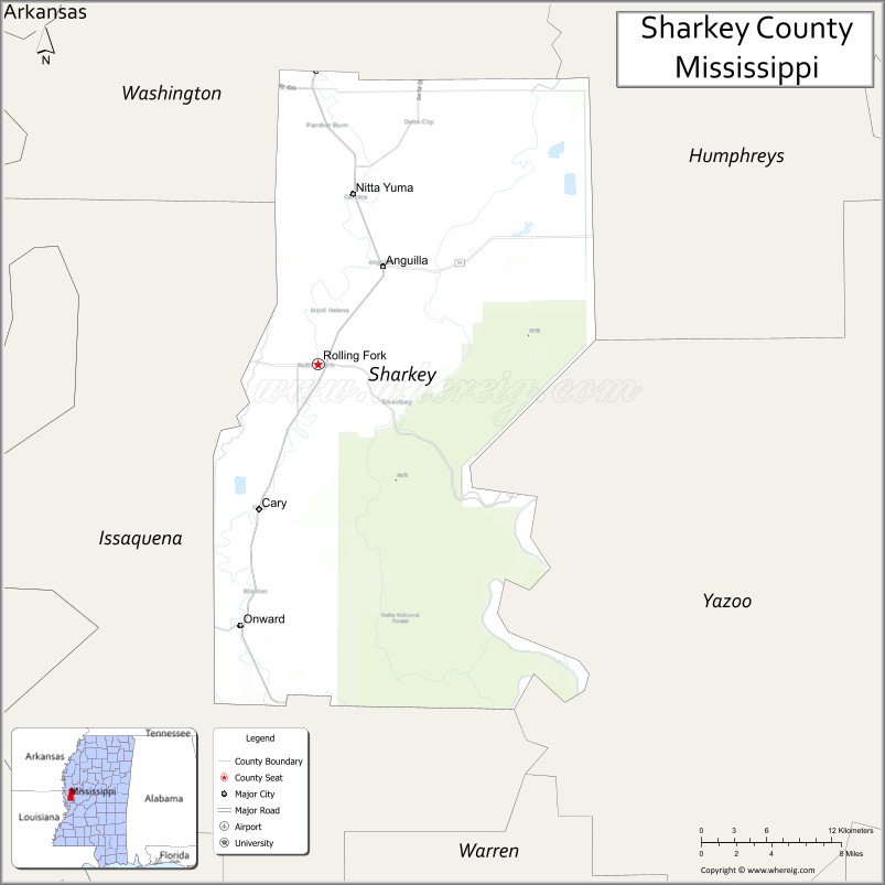
About Sharkey County Map, Mississippi: The map showing the county boundary, county seat, major cities, highways, water bodies and neighbouring counties.
Other Mississippi Maps & Info
Sharkey County, Mississippi
Sharkey County is a county located in the U.S. state of Mississippi. It's county seat is Rolling Fork. As per 2020 census, the population of Sharkey County is 3663 people and population density is square miles. According to the United States Census Bureau, the county has a total area of 428 sq mi (1,109 km2). Sharkey County was established on 1876.
Sharkey County Facts
| Continent | North America |
| Country | United States |
| State | Mississippi |
| County Seat | Rolling Fork |
| Largest City/Town | Rolling Fork |
| Established | 1876 |
| Total Area | 435 sq mi (1,127 sq km) |
| Land Area | 432 sq mi (1,119 sq km) |
| Water Area | 3 sq mi (8 sq km) |
| Population | 3,800 (Census 2020) |
| Population Density | 9 people per sq mi |
| Time Zone | Central Time Zone (CST/CDT) |
| Major Highways | U.S. Route 61, Mississippi Highway 14, Mississippi Highway 16 |
| Major Rivers | Mississippi River, Sunflower River, Deer Creek |
| Neighboring Counties | Washington County, Humphreys County, Issaquena County, Yazoo County, Warren County |
| Famous For | Mississippi Delta agriculture, blues heritage, and wildlife areas |
| Top Attractions | Theodore Roosevelt National Wildlife Refuge, Rolling Fork historic sites, and Delta hunting areas |
| Official Website | Official Website |
About Sharkey County, Mississippi
Sharkey County is located in the western Mississippi Delta region of Mississippi in the southern United States and was established in 1876. The county seat and largest city is Rolling Fork. The county is known for its fertile Delta farmland, hunting lands, rivers, and connections to blues and outdoor culture in the Mississippi Delta.
Cities and Towns in Sharkey County, Mississippi
| City/Town | Population (Census 2020) | Latitude & Longitude |
|---|---|---|
| Rolling Fork (county seat) | 1,883 | 32.9079°N, 90.8787°W |
| Anguilla | 726 | 32.9987°N, 90.8254°W |
| Cary | 242 | 32.3015°N, 90.9490°W |
| Nitta Yuma (CDP) | 8 | 32.5882°N, 90.9556°W |
Golf Courses in Sharkey County, Mississippi
| Golf Course | Location | Latitude & Longitude |
|---|---|---|
| Rolling Fork Golf Club | Rolling Fork | 32.9108°N, 90.8862°W |
What Are the Major Roads and Highways in Sharkey County, Mississippi
Major highways connect the county to nearby Delta communities and regional destinations.
- U.S. Route 61 - major north-south highway linking Rolling Fork with Greenville and Vicksburg
- Mississippi Highway 14 - east-west route connecting Rolling Fork with nearby Delta towns
- Mississippi Highway 16 - regional route serving agricultural communities in the county
What are the Neighboring Counties of Sharkey County
- Washington County (north)
- Humphreys County (east)
- Yazoo County (southeast)
- Warren County (south)
- Issaquena County (west)
What Are the Top Attractions in Sharkey County, Mississippi
The county offers a mix of Delta heritage sites and natural attractions.
- Theodore Roosevelt National Wildlife Refuge - protected wildlife area with birdwatching and hunting opportunities
- Rolling Fork Historic District - historic downtown area with classic Mississippi Delta architecture
- Mississippi Delta Hunting Lands - large outdoor areas popular for deer and waterfowl hunting
- Sunflower River - scenic Delta river known for fishing and boating
- Deer Creek - historic waterway associated with Mississippi Delta history and recreation
- Great River Road Scenic Byway - scenic driving route passing through nearby Delta landscapes
- Rolling Fork Railroad Area - historic transportation-related district in the county seat
- Delta Agricultural Landscapes - expansive farmland representing traditional Mississippi Delta agriculture
- Sharkey County Courthouse - historic courthouse located in Rolling Fork
- Wildlife Observation Areas - natural habitats attracting migratory birds and native wildlife
Distance from Sharkey County to Nearby Cities
The following distances are measured by road (driving).
- Rolling Fork to Greenville (Washington County), Mississippi - 52 mi (84 km)
- Rolling Fork to Vicksburg (Warren County), Mississippi - 58 mi (93 km)
- Rolling Fork to Yazoo City (Yazoo County), Mississippi - 61 mi (98 km)
- Rolling Fork to Jackson (Hinds County), Mississippi - 108 mi (174 km)
- Rolling Fork to Greenwood (Leflore County), Mississippi - 71 mi (114 km)
- Rolling Fork to Indianola (Sunflower County), Mississippi - 58 mi (93 km)
- Rolling Fork to Belzoni (Humphreys County), Mississippi - 39 mi (63 km)
- Rolling Fork to Clarksdale (Coahoma County), Mississippi - 117 mi (188 km)
- Rolling Fork to Cleveland (Bolivar County), Mississippi - 73 mi (117 km)
- Rolling Fork to Natchez (Adams County), Mississippi - 89 mi (143 km)
- Rolling Fork to Anguilla (Sharkey County), Mississippi - 10 mi (16 km)
- Rolling Fork to Cary (Sharkey County), Mississippi - 44 mi (71 km)
- Rolling Fork to Memphis (Shelby County), Tennessee - 171 mi (275 km)
FAQs about Sharkey County
Sharkey County is located in the western Mississippi Delta region near the Mississippi River.
Sharkey County had a population of 3,800 according to the 2020 United States Census.
Sharkey County is known for Delta agriculture, wildlife refuges, hunting lands, and Mississippi Delta culture.
The county is served by U.S. Route 61, Mississippi Highway 14, and Mississippi Highway 16.
Yes, Sharkey County includes the Rolling Fork Golf Club in Rolling Fork.
References
- QuickFacts - U.S. Census Bureau
- United States Census Bureau
- United States Geological Survey (USGS)
- National Geodetic Survey
- Official County Website
- Adams County Map
- Alcorn County Map
- Amite County Map
- Attala County Map
- Benton County Map
- Bolivar County Map
- Calhoun County Map
- Carroll County Map
- Chickasaw County Map
- Choctaw County Map
- Claiborne County Map
- Clarke County Map
- Clay County Map
- Coahoma County Map
- Copiah County Map
- Covington County Map
- DeSoto County Map
- Forrest County Map
- Franklin County Map
- George County Map
- Greene County Map
- Grenada County Map
- Hancock County Map
- Harrison County Map
- Hinds County Map
- Holmes County Map
- Humphreys County Map
- Issaquena County Map
- Itawamba County Map
- Jackson County Map
- Jasper County Map
- Jefferson County Map
- Jefferson Davis County Map
- Jones County Map
- Kemper County Map
- Lafayette County Map
- Lamar County Map
- Lauderdale County Map
- Lawrence County Map
- Leake County Map
- Lee County Map
- Leflore County Map
- Lincoln County Map
- Lowndes County Map
- Madison County Map
- Marion County Map
- Marshall County Map
- Monroe County Map
- Montgomery County Map
- Neshoba County Map
- Newton County Map
- Noxubee County Map
- Oktibbeha County Map
- Panola County Map
- Pearl River County Map
- Perry County Map
- Pike County Map
- Pontotoc County Map
- Prentiss County Map
- Quitman County Map
- Rankin County Map
- Scott County Map
- Sharkey County Map
- Simpson County Map
- Smith County Map
- Stone County Map
- Sunflower County Map
- Tallahatchie County Map
- Tate County Map
- Tippah County Map
- Tishomingo County Map
- Tunica County Map
- Union County Map
- Walthall County Map
- Warren County Map
- Washington County Map
- Wayne County Map
- Webster County Map
- Wilkinson County Map
- Winston County Map
- Yalobusha County Map
- Yazoo County Map
- Alabama Counties
- Alaska boroughs
- Arizona Counties
- Arkansas Counties
- California County Map
- Colorado Counties
- Connecticut Counties
- Delaware Counties
- Florida County Map
- Georgia County Map
- Hawaii Counties
- Idaho Counties
- Illinois Counties
- Indiana Counties
- Iowa Counties
- Kansas Counties
- Kentucky Counties
- Louisiana Counties
- Maine Counties
- Maryland Counties
- Massachusetts Counties
- Michigan County Map
- Minnesota Counties
- Mississippi Counties
- Missouri Counties
- Montana Counties
- Nebraska Counties
- Nevada Counties
- New York Counties
- New Hampshire Counties
- New Jersey Counties
- New Mexico Counties
- North Carolina Counties
- North Dakota Counties
- Ohio County Map
- Oklahoma Counties
- Oregon Counties
- Pennsylvania Counties
- Rhode Island Counties
- South Carolina Counties
- South Dakota Counties
- Map of Tennessee
- Texas County Map
- Utah Counties
- Vermont Counties
- Virginia Counties
- Washington Counties
- West Virginia Counties
- Wisconsin Counties
- Wyoming Counties