Written and Fact-checked by Whereig Editors, Reviewed by Mukesh Kumar| Last Updated On: May 12, 2026
Map of Newton County - Newton County is a county located in the U.S. state of Mississippi. Newton County Map showing cities, highways, important places and water bodies. Get Where is Newton County located in the map, major cities in Newton county, population, areas, and places of interest.
Map of Newton County, Mississippi
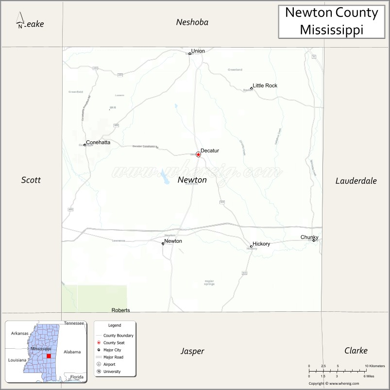
About Newton County Map, Mississippi: The map showing the county boundary, county seat, major cities, highways, water bodies and neighbouring counties.
Other Mississippi Maps & Info
Newton County, Mississippi
Newton County is a county located in the U.S. state of Mississippi. It's county seat is Decatur. As per 2020 census, the population of Newton County is 21056 people and population density is square miles. According to the United States Census Bureau, the county has a total area of 578 sq mi (1,497 km2). Newton County was established on 1836.
Newton County Facts
| Continent | North America |
| Country | United States |
| State | Mississippi |
| County Seat | Decatur |
| Largest City/Town | Newton |
| Established | 1836 |
| Total Area | 580 sq mi (1,502 sq km) |
| Land Area | 578 sq mi (1,497 sq km) |
| Water Area | 2 sq mi (5 sq km) |
| Population | 21,291 (Census 2020) |
| Population Density | 36.8 people per sq mi |
| Time Zone | Central Time Zone |
| Major Highways | Interstate 20, U.S. Route 80, Mississippi Highway 15 |
| Major Rivers | Chunky River, Chickasawhay River nearby watershed |
| Neighboring Counties | Scott County, Jasper County, Lauderdale County, Kemper County, Neshoba County |
| Famous For | Poultry farming, historic railroad towns, and East Central Mississippi industry |
| Top Attractions | Newton Depot Museum, Bienville National Forest nearby region, and Roosevelt State Park nearby area |
| Official Website | Official Website |
About Newton County, Mississippi
Newton County is located in east-central Mississippi and was established in 1836. The county seat is Decatur, while Newton is the largest city. Newton County is known for agriculture, poultry production, historic railroad communities, forestry, and outdoor recreation opportunities in nearby forest regions.
Cities and Towns in Newton County, Mississippi
| City/Town | Population (Census 2020) | Latitude & Longitude |
|---|---|---|
| Newton | 2,988 | 32.3210°N, 89.1634°W |
| Decatur (county seat) | 1,472 | 32.4387°N, 89.1081°W |
| Hickory | 530 | 32.3185°N, 89.0259°W |
| Chunky | 291 | 32.3293°N, 88.9384°W |
| Union | 1,988 | 32.5710°N, 89.1217°W |
| Conehatta nearby region | 1,300 | 32.4512°N, 89.0214°W |
Golf Courses in Newton County, Mississippi
| Golf Course | Location | Latitude & Longitude |
|---|---|---|
| Newton Country Club | Newton | 32.3306°N, 89.1738°W |
| Philadelphia and East Central Regional Golf Facilities nearby region | Nearby region | 32.3221°N, 89.1602°W |
| Forest Area Golf Courses nearby region | East Central Mississippi | 32.3647°N, 89.0941°W |
What Are the Major Roads and Highways in Newton County
Major highways provide connections between Newton County and major Mississippi cities.
- Interstate 20 - major east-west interstate connecting Jackson and Meridian
- U.S. Route 80 - historic transportation corridor through east-central Mississippi
- Mississippi Highway 15 - regional north-south highway serving local communities
What are the Neighboring Counties of Newton County
- Neshoba County (north)
- Kemper County (east)
- Lauderdale County (southeast)
- Jasper County (south)
- Scott County (west)
What Are the Top Attractions in Newton County
The county offers outdoor recreation, railroad heritage, and scenic East Central Mississippi landscapes.
- Newton Depot Museum - exhibits preserving local railroad and community history
- Bienville National Forest Nearby Region - hiking, camping, fishing, and wildlife observation opportunities
- Roosevelt State Park Nearby Area - boating, cabins, and outdoor recreation destination
- Historic Downtown Newton - small-town shops, restaurants, and preserved architecture
- Chunky River Recreation Areas - fishing, kayaking, and scenic nature spots
- Conehatta Community Cultural Sites - heritage attractions connected to Choctaw traditions
- East Central Mississippi Scenic Drives - forests, farmland, and rolling countryside landscapes
- Community Parks and Sports Facilities - recreation opportunities for families and visitors
- Historic Churches and Heritage Landmarks - preserved structures reflecting regional history
- Annual Festivals and Agricultural Events - celebrations featuring local crafts, food, and traditions
Distance from Newton County to Nearby Cities
The following distances are measured by road (driving).
- Newton to Meridian, Mississippi - 32 mi (51 km)
- Newton to Jackson, Mississippi - 74 mi (119 km)
- Newton to Hattiesburg, Mississippi - 89 mi (143 km)
- Newton to Starkville, Mississippi - 101 mi (163 km)
- Newton to Birmingham, Alabama - 147 mi (237 km)
- Newton to Tupelo, Mississippi - 151 mi (243 km)
- Newton to Mobile, Alabama - 188 mi (303 km)
- Newton to Memphis, Tennessee - 223 mi (359 km)
- Newton to Atlanta, Georgia - 263 mi (423 km)
- Newton to New Orleans, Louisiana - 222 mi (357 km)
- Newton to Dallas, Texas - 472 mi (760 km)
- Newton to Houston, Texas - 430 mi (692 km)
FAQs about Newton County
Newton County is located in east-central Mississippi.
Newton County had a population of 21,291 according to Census 2020 data.
Newton County is known for poultry farming, historic railroad towns, and East Central Mississippi industry.
The county is served by Interstate 20, U.S. Route 80, and Mississippi Highway 15.
Yes, Newton County has golf facilities including Newton Country Club and nearby regional golf courses.
References
- QuickFacts - U.S. Census Bureau
- United States Census Bureau
- Official County Website
- Bienville National Forest
- Roosevelt State Park
- Adams County Map
- Alcorn County Map
- Amite County Map
- Attala County Map
- Benton County Map
- Bolivar County Map
- Calhoun County Map
- Carroll County Map
- Chickasaw County Map
- Choctaw County Map
- Claiborne County Map
- Clarke County Map
- Clay County Map
- Coahoma County Map
- Copiah County Map
- Covington County Map
- DeSoto County Map
- Forrest County Map
- Franklin County Map
- George County Map
- Greene County Map
- Grenada County Map
- Hancock County Map
- Harrison County Map
- Hinds County Map
- Holmes County Map
- Humphreys County Map
- Issaquena County Map
- Itawamba County Map
- Jackson County Map
- Jasper County Map
- Jefferson County Map
- Jefferson Davis County Map
- Jones County Map
- Kemper County Map
- Lafayette County Map
- Lamar County Map
- Lauderdale County Map
- Lawrence County Map
- Leake County Map
- Lee County Map
- Leflore County Map
- Lincoln County Map
- Lowndes County Map
- Madison County Map
- Marion County Map
- Marshall County Map
- Monroe County Map
- Montgomery County Map
- Neshoba County Map
- Newton County Map
- Noxubee County Map
- Oktibbeha County Map
- Panola County Map
- Pearl River County Map
- Perry County Map
- Pike County Map
- Pontotoc County Map
- Prentiss County Map
- Quitman County Map
- Rankin County Map
- Scott County Map
- Sharkey County Map
- Simpson County Map
- Smith County Map
- Stone County Map
- Sunflower County Map
- Tallahatchie County Map
- Tate County Map
- Tippah County Map
- Tishomingo County Map
- Tunica County Map
- Union County Map
- Walthall County Map
- Warren County Map
- Washington County Map
- Wayne County Map
- Webster County Map
- Wilkinson County Map
- Winston County Map
- Yalobusha County Map
- Yazoo County Map
- Alabama Counties
- Alaska boroughs
- Arizona Counties
- Arkansas Counties
- California County Map
- Colorado Counties
- Connecticut Counties
- Delaware Counties
- Florida County Map
- Georgia County Map
- Hawaii Counties
- Idaho Counties
- Illinois Counties
- Indiana Counties
- Iowa Counties
- Kansas Counties
- Kentucky Counties
- Louisiana Counties
- Maine Counties
- Maryland Counties
- Massachusetts Counties
- Michigan County Map
- Minnesota Counties
- Mississippi Counties
- Missouri Counties
- Montana Counties
- Nebraska Counties
- Nevada Counties
- New York Counties
- New Hampshire Counties
- New Jersey Counties
- New Mexico Counties
- North Carolina Counties
- North Dakota Counties
- Ohio County Map
- Oklahoma Counties
- Oregon Counties
- Pennsylvania Counties
- Rhode Island Counties
- South Carolina Counties
- South Dakota Counties
- Map of Tennessee
- Texas County Map
- Utah Counties
- Vermont Counties
- Virginia Counties
- Washington Counties
- West Virginia Counties
- Wisconsin Counties
- Wyoming Counties