Written and Fact-checked by Whereig Editors, Reviewed by Mukesh Kumar| Last Updated On: May 12, 2026
Map of Rankin County - Rankin County is a county located in the U.S. state of Mississippi. Rankin County Map showing cities, highways, important places and water bodies. Get Where is Rankin County located in the map, major cities in Rankin county, population, areas, and places of interest.
Map of Rankin County, Mississippi
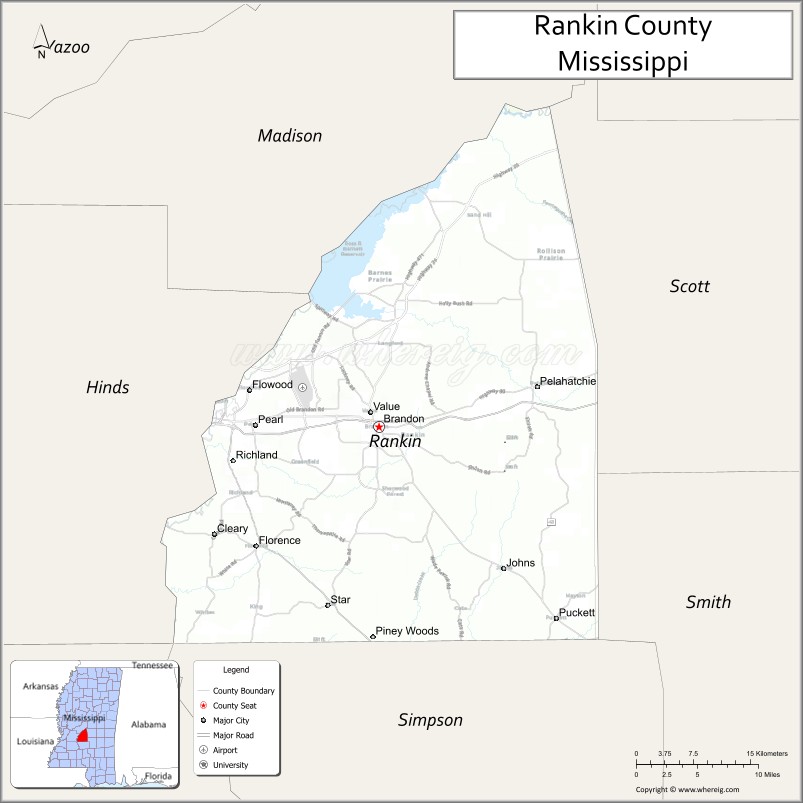
About Rankin County Map, Mississippi: The map showing the county boundary, county seat, major cities, highways, water bodies and neighbouring counties.
Other Mississippi Maps & Info
Rankin County, Mississippi
Rankin County is a county located in the U.S. state of Mississippi. It's county seat is Brandon. As per 2020 census, the population of Rankin County is 158096 people and population density is square miles. According to the United States Census Bureau, the county has a total area of 775 sq mi (2,007 km2). Rankin County was established on 1828.
Rankin County Facts
| Continent | North America |
| Country | United States |
| State | Mississippi |
| County Seat | Brandon |
| Largest City/Town | Pearl |
| Established | 1828 |
| Total Area | 806 sq mi (2,088 sq km) |
| Land Area | 775 sq mi (2,007 sq km) |
| Water Area | 31 sq mi (80 sq km) |
| Population | 157,031 (Census 2020) |
| Population Density | 203 people per sq mi |
| Time Zone | Central Time Zone (CST/CDT) |
| Major Highways | Interstate 20, Interstate 55, U.S. Route 49, U.S. Route 80, Mississippi Highway 25, Mississippi Highway 43 |
| Major Rivers | Pearl River, Strong River |
| Neighboring Counties | Madison County, Scott County, Smith County, Simpson County, Hinds County, Leake County |
| Famous For | Ross Barnett Reservoir, suburban Jackson communities, shopping, and outdoor recreation |
| Top Attractions | Ross Barnett Reservoir, Mississippi Braves Stadium, Trustmark Park, LeFleur's Bluff recreation areas, and Flowood shopping districts |
| Official Website | Official Website |
About Rankin County, Mississippi
Rankin County is located in central Mississippi in the southern United States and was established in 1828. The county seat is Brandon, while Pearl is the largest city. The county is part of the Jackson metropolitan area and is known for its growing suburban communities, major shopping areas, parks, and outdoor recreation centered around the Ross Barnett Reservoir.
Cities and Towns in Rankin County, Mississippi
| City/Town | Population (Census 2020) | Latitude & Longitude |
|---|---|---|
| Brandon (county seat) | 25,138 | 32.2738°N, 89.9859°W |
| Pearl | 27,995 | 32.2746°N, 90.1320°W |
| Flowood | 10,436 | 32.3096°N, 90.1384°W |
| Richland | 7,775 | 32.2390°N, 90.1590°W |
| Florence | 4,479 | 32.1535°N, 90.1318°W |
| Pelahatchie | 1,390 | 32.3179°N, 89.7984°W |
| Puckett | 326 | 32.0818°N, 89.7976°W |
| Cleary (CDP) | 1,688 | 32.2857°N, 89.9294°W |
| Robinhood (CDP) | 1,491 | 32.3044°N, 90.0265°W |
| Star (CDP) | 1,095 | 32.1023°N, 89.8797°W |
Golf Courses in Rankin County, Mississippi
| Golf Course | Location | Latitude & Longitude |
|---|---|---|
| Castlewoods Country Club | Brandon | 32.3374°N, 90.0189°W |
| The Refuge Golf Course | Flowood | 32.3345°N, 90.0216°W |
| Bay Pointe Resort and Golf Club | Brandon | 32.3775°N, 90.0328°W |
| Patrick Farms Golf Club | Pearl | 32.2387°N, 90.0478°W |
| Canebrake Country Club | Flowood | 32.3401°N, 90.1064°W |
| Live Oaks Golf Club | Flowood | 32.3278°N, 90.1120°W |
What Are the Major Roads and Highways in Rankin County, Mississippi
Major highways connect the county to nearby cities and regional destinations.
- Interstate 20 - runs east-west connecting the county with Jackson, Meridian, and Dallas
- Interstate 55 - passes near the western side of the county connecting Jackson and Memphis
- U.S. Route 49 - connects Richland and Florence with Jackson and Hattiesburg
- U.S. Route 80 - historic east-west route through Pearl and Brandon
- Mississippi Highway 25 - connects Flowood with Starkville and central Mississippi communities
- Mississippi Highway 43 - serves rural eastern sections of the county
What are the Neighboring Counties of Rankin County
- Madison County (north)
- Leake County (northeast)
- Scott County (east)
- Smith County (southeast)
- Simpson County (south)
- Hinds County (west)
What Are the Top Attractions in Rankin County, Mississippi
The county offers a mix of natural, recreational, and entertainment attractions.
- Ross Barnett Reservoir - large reservoir popular for boating, fishing, and water sports
- Trustmark Park - baseball stadium home to the Mississippi Braves
- The Refuge Golf Course - well-known public golf course near the reservoir
- Brandon Amphitheater - major outdoor concert and entertainment venue
- Winner's Circle Park - family recreation area with sports and walking trails
- Flowood Nature Park - natural area with walking trails and wildlife viewing
- Pearl River Valley Water Supply District - recreation area with campgrounds and marinas
- Old Brandon Historic District - historic downtown area with shops and restaurants
- Mississippi Agriculture and Forestry Museum vicinity - nearby educational attraction in the metro area
- Bay Pointe Marina - boating and lakeside recreation destination on the reservoir
Distance from Rankin County to Nearby Cities
The following distances are measured by road (driving).
- Brandon to Jackson (Hinds County), Mississippi - 14 mi (23 km)
- Brandon to Pearl (Rankin County), Mississippi - 8 mi (13 km)
- Brandon to Flowood (Rankin County), Mississippi - 9 mi (14 km)
- Brandon to Meridian (Lauderdale County), Mississippi - 93 mi (150 km)
- Brandon to Hattiesburg (Forrest County), Mississippi - 88 mi (142 km)
- Brandon to Vicksburg (Warren County), Mississippi - 57 mi (92 km)
- Brandon to Starkville (Oktibbeha County), Mississippi - 122 mi (196 km)
- Brandon to Tupelo (Lee County), Mississippi - 177 mi (285 km)
- Brandon to Natchez (Adams County), Mississippi - 108 mi (174 km)
- Brandon to Florence (Rankin County), Mississippi - 16 mi (26 km)
- Brandon to Pelahatchie (Rankin County), Mississippi - 22 mi (35 km)
- Brandon to Richland (Rankin County), Mississippi - 13 mi (21 km)
- Brandon to Memphis (Shelby County), Tennessee - 211 mi (340 km)
FAQs about Rankin County
Rankin County is located in central Mississippi and is part of the Jackson metropolitan area.
Rankin County had a population of 157,031 according to the 2020 United States Census.
Rankin County is known for the Ross Barnett Reservoir, suburban communities, recreation, and shopping destinations.
The county is served by Interstate 20, Interstate 55, U.S. Route 49, and U.S. Route 80.
Yes, Rankin County has several golf courses including Castlewoods Country Club, The Refuge Golf Course, and Patrick Farms Golf Club.
References
- QuickFacts - U.S. Census Bureau
- United States Census Bureau
- United States Geological Survey (USGS)
- National Geodetic Survey
- Official County Website
- Adams County Map
- Alcorn County Map
- Amite County Map
- Attala County Map
- Benton County Map
- Bolivar County Map
- Calhoun County Map
- Carroll County Map
- Chickasaw County Map
- Choctaw County Map
- Claiborne County Map
- Clarke County Map
- Clay County Map
- Coahoma County Map
- Copiah County Map
- Covington County Map
- DeSoto County Map
- Forrest County Map
- Franklin County Map
- George County Map
- Greene County Map
- Grenada County Map
- Hancock County Map
- Harrison County Map
- Hinds County Map
- Holmes County Map
- Humphreys County Map
- Issaquena County Map
- Itawamba County Map
- Jackson County Map
- Jasper County Map
- Jefferson County Map
- Jefferson Davis County Map
- Jones County Map
- Kemper County Map
- Lafayette County Map
- Lamar County Map
- Lauderdale County Map
- Lawrence County Map
- Leake County Map
- Lee County Map
- Leflore County Map
- Lincoln County Map
- Lowndes County Map
- Madison County Map
- Marion County Map
- Marshall County Map
- Monroe County Map
- Montgomery County Map
- Neshoba County Map
- Newton County Map
- Noxubee County Map
- Oktibbeha County Map
- Panola County Map
- Pearl River County Map
- Perry County Map
- Pike County Map
- Pontotoc County Map
- Prentiss County Map
- Quitman County Map
- Rankin County Map
- Scott County Map
- Sharkey County Map
- Simpson County Map
- Smith County Map
- Stone County Map
- Sunflower County Map
- Tallahatchie County Map
- Tate County Map
- Tippah County Map
- Tishomingo County Map
- Tunica County Map
- Union County Map
- Walthall County Map
- Warren County Map
- Washington County Map
- Wayne County Map
- Webster County Map
- Wilkinson County Map
- Winston County Map
- Yalobusha County Map
- Yazoo County Map
- Alabama Counties
- Alaska boroughs
- Arizona Counties
- Arkansas Counties
- California County Map
- Colorado Counties
- Connecticut Counties
- Delaware Counties
- Florida County Map
- Georgia County Map
- Hawaii Counties
- Idaho Counties
- Illinois Counties
- Indiana Counties
- Iowa Counties
- Kansas Counties
- Kentucky Counties
- Louisiana Counties
- Maine Counties
- Maryland Counties
- Massachusetts Counties
- Michigan County Map
- Minnesota Counties
- Mississippi Counties
- Missouri Counties
- Montana Counties
- Nebraska Counties
- Nevada Counties
- New York Counties
- New Hampshire Counties
- New Jersey Counties
- New Mexico Counties
- North Carolina Counties
- North Dakota Counties
- Ohio County Map
- Oklahoma Counties
- Oregon Counties
- Pennsylvania Counties
- Rhode Island Counties
- South Carolina Counties
- South Dakota Counties
- Map of Tennessee
- Texas County Map
- Utah Counties
- Vermont Counties
- Virginia Counties
- Washington Counties
- West Virginia Counties
- Wisconsin Counties
- Wyoming Counties