Written and Fact-checked by Whereig Editors, Reviewed by Mukesh Kumar| Last Updated On: May 12, 2026
Map of Grenada County - Grenada County is a county located in the U.S. state of Mississippi. Grenada County Map showing cities, highways, important places and water bodies. Get Where is Grenada County located in the map, major cities in Grenada county, population, areas, and places of interest.
Map of Grenada County, Mississippi
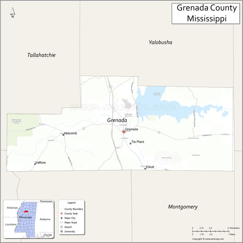
About Grenada County Map, Mississippi: The map showing the county boundary, county seat, major cities, highways, water bodies and neighbouring counties.
Other Mississippi Maps & Info
Grenada County, Mississippi
Grenada County is a county located in the U.S. state of Mississippi. It's county seat is Grenada. As per 2020 census, the population of Grenada County is 21365 people and population density is square miles. According to the United States Census Bureau, the county has a total area of 422 sq mi (1,093 km2). Grenada County was established on 1870.
Grenada County Facts
| Continent | North America |
| Country | United States |
| State | Mississippi |
| County Seat | Grenada |
| Largest City/Town | Grenada |
| Established | 1870 |
| Total Area | 449 sq mi (1,163 sq km) |
| Land Area | 422 sq mi (1,093 sq km) |
| Water Area | 27 sq mi (70 sq km) |
| Population | 21,629 (Census 2020) |
| Population Density | 51.3 people per sq mi |
| Time Zone | Central Time Zone |
| Major Highways | Interstate 55, U.S. Route 51, Mississippi Highway 8 |
| Major Rivers | Yalobusha River, Skuna River |
| Neighboring Counties | Tallahatchie County, Montgomery County, Carroll County, Yalobusha County, Calhoun County |
| Famous For | Grenada Lake, fishing tournaments, and outdoor recreation |
| Top Attractions | Grenada Lake, Hugh White State Park, and Grenada Historic District |
| Official Website | Official Website |
About Grenada County, Mississippi
Grenada County is located in north-central Mississippi and was established in 1870. The county seat and largest city is Grenada. The county is widely known for Grenada Lake, one of Mississippi’s premier outdoor recreation destinations, along with its fishing opportunities, scenic landscapes, and Southern hospitality.
Cities and Towns in Grenada County, Mississippi
| City/Town | Population (Census 2020) | Latitude & Longitude |
|---|---|---|
| Grenada (county seat) | 12,700 | 33.7690°N, 89.8084°W |
| Elliott | 960 | 33.6843°N, 89.7509°W |
| Duck Hill nearby region | 700 | 33.6301°N, 89.7078°W |
| Hardy nearby region | 500 | 33.8106°N, 89.8427°W |
Golf Courses in Grenada County, Mississippi
| Golf Course | Location | Latitude & Longitude |
|---|---|---|
| Grenada Country Club | Grenada | 33.7734°N, 89.8147°W |
| Dogwoods Golf Course at Hugh White State Park | Grenada Lake area | 33.8406°N, 89.7812°W |
What Are the Major Roads and Highways in Grenada County, Mississippi
Major highways connect Grenada County with northern Mississippi and regional transportation routes.
- Interstate 55 - major north-south interstate connecting Memphis and Jackson
- U.S. Route 51 - historic highway paralleling Interstate 55
- Mississippi Highway 8 - important east-west corridor serving regional communities
What are the Neighboring Counties of Grenada County
- Tallahatchie County (north)
- Yalobusha County (east)
- Calhoun County (southeast)
- Carroll County (south)
- Montgomery County (west)
What Are the Top Attractions in Grenada County, Mississippi
The county offers exceptional fishing, scenic outdoor recreation, and historic Southern attractions.
- Grenada Lake - one of Mississippi’s top destinations for boating, camping, and crappie fishing tournaments
- Hugh White State Park - recreation area featuring cabins, trails, camping, and lake access
- Grenada Historic District - downtown area with local restaurants, boutiques, and historic architecture
- Dogwoods Golf Course - scenic golf course overlooking the Grenada Lake region
- Grenada Lake Dam and Scenic Areas - popular spots for sightseeing, fishing, and photography
- Yalobusha River Recreation Areas - opportunities for canoeing, kayaking, and wildlife observation
- Scenic North Mississippi Drives - countryside routes showcasing forests and rolling hills
- Community Parks and Sports Facilities - family-friendly recreation areas throughout the county
- Annual Fishing and Outdoor Festivals - events celebrating regional outdoor traditions and tourism
- Historic Churches and Heritage Sites - preserved landmarks reflecting Mississippi history and culture
Distance from Grenada County to Nearby Cities
The following distances are measured by road (driving).
- Grenada to Oxford, Mississippi - 67 mi (108 km)
- Grenada to Tupelo, Mississippi - 92 mi (148 km)
- Grenada to Starkville, Mississippi - 91 mi (146 km)
- Grenada to Jackson, Mississippi - 116 mi (187 km)
- Grenada to Memphis, Tennessee - 105 mi (169 km)
- Grenada to Greenwood, Mississippi - 45 mi (72 km)
- Grenada to Birmingham, Alabama - 182 mi (293 km)
- Grenada to Little Rock, Arkansas - 180 mi (290 km)
- Grenada to Nashville, Tennessee - 245 mi (394 km)
- Grenada to New Orleans, Louisiana - 312 mi (502 km)
- Grenada to Atlanta, Georgia - 347 mi (558 km)
- Grenada to Dallas, Texas - 420 mi (676 km)
FAQs about Grenada County
Grenada County is located in north-central Mississippi.
Grenada County had a population of 21,629 according to Census 2020 data.
Grenada County is known for Grenada Lake, fishing tournaments, and outdoor recreation.
The county is served by Interstate 55, U.S. Route 51, and Mississippi Highway 8.
Yes, Grenada County has golf facilities including Grenada Country Club and Dogwoods Golf Course at Hugh White State Park.
References
- QuickFacts - U.S. Census Bureau
- United States Census Bureau
- Hugh White State Park
- Visit Mississippi
- Official County Website
- Adams County Map
- Alcorn County Map
- Amite County Map
- Attala County Map
- Benton County Map
- Bolivar County Map
- Calhoun County Map
- Carroll County Map
- Chickasaw County Map
- Choctaw County Map
- Claiborne County Map
- Clarke County Map
- Clay County Map
- Coahoma County Map
- Copiah County Map
- Covington County Map
- DeSoto County Map
- Forrest County Map
- Franklin County Map
- George County Map
- Greene County Map
- Grenada County Map
- Hancock County Map
- Harrison County Map
- Hinds County Map
- Holmes County Map
- Humphreys County Map
- Issaquena County Map
- Itawamba County Map
- Jackson County Map
- Jasper County Map
- Jefferson County Map
- Jefferson Davis County Map
- Jones County Map
- Kemper County Map
- Lafayette County Map
- Lamar County Map
- Lauderdale County Map
- Lawrence County Map
- Leake County Map
- Lee County Map
- Leflore County Map
- Lincoln County Map
- Lowndes County Map
- Madison County Map
- Marion County Map
- Marshall County Map
- Monroe County Map
- Montgomery County Map
- Neshoba County Map
- Newton County Map
- Noxubee County Map
- Oktibbeha County Map
- Panola County Map
- Pearl River County Map
- Perry County Map
- Pike County Map
- Pontotoc County Map
- Prentiss County Map
- Quitman County Map
- Rankin County Map
- Scott County Map
- Sharkey County Map
- Simpson County Map
- Smith County Map
- Stone County Map
- Sunflower County Map
- Tallahatchie County Map
- Tate County Map
- Tippah County Map
- Tishomingo County Map
- Tunica County Map
- Union County Map
- Walthall County Map
- Warren County Map
- Washington County Map
- Wayne County Map
- Webster County Map
- Wilkinson County Map
- Winston County Map
- Yalobusha County Map
- Yazoo County Map
- Alabama Counties
- Alaska boroughs
- Arizona Counties
- Arkansas Counties
- California County Map
- Colorado Counties
- Connecticut Counties
- Delaware Counties
- Florida County Map
- Georgia County Map
- Hawaii Counties
- Idaho Counties
- Illinois Counties
- Indiana Counties
- Iowa Counties
- Kansas Counties
- Kentucky Counties
- Louisiana Counties
- Maine Counties
- Maryland Counties
- Massachusetts Counties
- Michigan County Map
- Minnesota Counties
- Mississippi Counties
- Missouri Counties
- Montana Counties
- Nebraska Counties
- Nevada Counties
- New York Counties
- New Hampshire Counties
- New Jersey Counties
- New Mexico Counties
- North Carolina Counties
- North Dakota Counties
- Ohio County Map
- Oklahoma Counties
- Oregon Counties
- Pennsylvania Counties
- Rhode Island Counties
- South Carolina Counties
- South Dakota Counties
- Map of Tennessee
- Texas County Map
- Utah Counties
- Vermont Counties
- Virginia Counties
- Washington Counties
- West Virginia Counties
- Wisconsin Counties
- Wyoming Counties