Written and Fact-checked by Whereig Editors, Reviewed by Mukesh Kumar| Last Updated On: May 12, 2026
Map of Webster County - Webster County is a county located in the U.S. state of Mississippi. Webster County Map showing cities, highways, important places and water bodies. Get Where is Webster County located in the map, major cities in Webster county, population, areas, and places of interest.
Map of Webster County, Mississippi
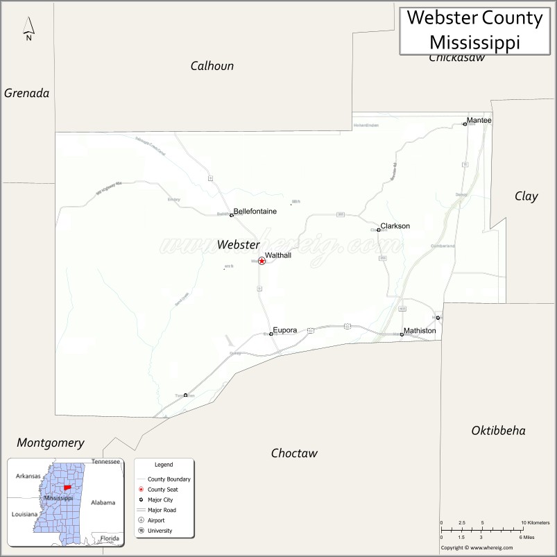
About Webster County Map, Mississippi: The map showing the county boundary, county seat, major cities, highways, water bodies and neighbouring counties.
Other Mississippi Maps & Info
Webster County, Mississippi
Webster County is a county located in the U.S. state of Mississippi. It's county seat is Walthall. As per 2020 census, the population of Webster County is 9983 people and population density is square miles. According to the United States Census Bureau, the county has a total area of 423 sq mi (1,096 km2). Webster County was established on 1874.
Webster County Facts
| Continent | North America |
| Country | United States |
| State | Mississippi |
| County Seat | Walthall |
| Largest City/Town | Eupora |
| Established | 1874 |
| Total Area | 423 sq mi (1,096 sq km) |
| Land Area | 421 sq mi (1,090 sq km) |
| Water Area | 2 sq mi (6 sq km) |
| Population | 9,420 (Census 2020) |
| Population Density | 22 people per sq mi |
| Time Zone | Central Time Zone (CST/CDT) |
| Major Highways | U.S. Route 82, Mississippi Highway 9, Mississippi Highway 15, Mississippi Highway 389 |
| Major Rivers | Big Black River, Houlka Creek |
| Neighboring Counties | Choctaw County, Clay County, Oktibbeha County, Chickasaw County, Montgomery County, Calhoun County |
| Famous For | Scenic countryside, Eupora heritage, and outdoor recreation |
| Top Attractions | Mathiston Historic Area, Big Black River recreation, Eupora downtown district, and Webster County Fairgrounds |
| Official Website | Official Website |
About Webster County, Mississippi
Webster County is located in east-central Mississippi in the southern United States and was established in 1874. The county seat is Walthall, while Eupora is the largest town. The county is known for its rural landscapes, agriculture, outdoor recreation, and traditional small-town Mississippi culture.
Cities and Towns in Webster County, Mississippi
| City/Town | Population (Census 2020) | Latitude & Longitude |
|---|---|---|
| Eupora | 1,884 | 33.5401°N, 89.2670°W |
| Mathiston | 698 | 33.5429°N, 89.1245°W |
| Walthall (county seat) | 144 | 33.6115°N, 89.2828°W |
| Maben | 840 | 33.5559°N, 89.0826°W |
| Cumberland (CDP) | 258 | 33.6122°N, 89.2186°W |
| Tomnolen (CDP) | 313 | 33.7585°N, 89.2781°W |
Golf Courses in Webster County, Mississippi
| Golf Course | Location | Latitude & Longitude |
|---|---|---|
| Eupora Country Club | Eupora | 33.5448°N, 89.2756°W |
| Webster County Golf Recreation Area | Mathiston | 33.5459°N, 89.1302°W |
What Are the Major Roads and Highways in Webster County, Mississippi
Major highways connect the county to nearby central and northern Mississippi communities.
- U.S. Route 82 - major east-west highway linking Eupora with Starkville and Greenwood
- Mississippi Highway 9 - north-south route connecting Webster County with Ackerman and Pontotoc
- Mississippi Highway 15 - regional highway serving local communities and agricultural areas
- Mississippi Highway 389 - scenic local route connecting smaller communities in the county
What are the Neighboring Counties of Webster County
- Chickasaw County (north)
- Clay County (east)
- Oktibbeha County (southeast)
- Choctaw County (south)
- Montgomery County (west)
- Calhoun County (northwest)
What Are the Top Attractions in Webster County, Mississippi
The county offers a mix of rural attractions and outdoor recreation areas.
- Eupora Historic Downtown - small-town district with local shops and historic architecture
- Big Black River Recreation Areas - scenic outdoor destinations for fishing and boating
- Webster County Fairgrounds - site of local fairs, rodeos, and community events
- Mathiston Historic Area - traditional Mississippi small-town community with local heritage
- Eupora Country Club - local golf and recreation facility
- Tomnolen Countryside - scenic rural landscapes featuring farmland and forests
- Maben Community Park - recreation area with sports and picnic facilities
- Houlka Creek Scenic Areas - natural settings for outdoor activities and wildlife viewing
- Walthall Courthouse Area - historic county government district
- North Central Mississippi Scenic Drives - countryside routes with rolling hills and agricultural scenery
Distance from Webster County to Nearby Cities
The following distances are measured by road (driving).
- Eupora to Starkville (Oktibbeha County), Mississippi - 37 mi (60 km)
- Eupora to Columbus (Lowndes County), Mississippi - 63 mi (101 km)
- Eupora to Greenwood (Leflore County), Mississippi - 49 mi (79 km)
- Eupora to Tupelo (Lee County), Mississippi - 62 mi (100 km)
- Eupora to Oxford (Lafayette County), Mississippi - 78 mi (126 km)
- Eupora to Jackson (Hinds County), Mississippi - 117 mi (188 km)
- Eupora to Grenada (Grenada County), Mississippi - 34 mi (55 km)
- Eupora to Mathiston (Webster County), Mississippi - 9 mi (14 km)
- Eupora to Maben (Webster County), Mississippi - 13 mi (21 km)
- Eupora to Walthall (Webster County), Mississippi - 8 mi (13 km)
- Eupora to West Point (Clay County), Mississippi - 37 mi (60 km)
- Eupora to Winona (Montgomery County), Mississippi - 25 mi (40 km)
- Eupora to Birmingham (Jefferson County), Alabama - 152 mi (245 km)
FAQs about Webster County
Webster County is located in east-central Mississippi between Starkville and Greenwood.
Webster County had a population of 9,420 according to the 2020 United States Census.
Webster County is known for scenic countryside, outdoor recreation, and small-town Mississippi heritage.
The county is served by U.S. Route 82, Mississippi Highway 9, Mississippi Highway 15, and Mississippi Highway 389.
Yes, Webster County includes golf facilities such as Eupora Country Club and local recreation golf areas.
References
- QuickFacts - U.S. Census Bureau
- United States Census Bureau
- United States Geological Survey (USGS)
- National Geodetic Survey
- Official Website
- Adams County Map
- Alcorn County Map
- Amite County Map
- Attala County Map
- Benton County Map
- Bolivar County Map
- Calhoun County Map
- Carroll County Map
- Chickasaw County Map
- Choctaw County Map
- Claiborne County Map
- Clarke County Map
- Clay County Map
- Coahoma County Map
- Copiah County Map
- Covington County Map
- DeSoto County Map
- Forrest County Map
- Franklin County Map
- George County Map
- Greene County Map
- Grenada County Map
- Hancock County Map
- Harrison County Map
- Hinds County Map
- Holmes County Map
- Humphreys County Map
- Issaquena County Map
- Itawamba County Map
- Jackson County Map
- Jasper County Map
- Jefferson County Map
- Jefferson Davis County Map
- Jones County Map
- Kemper County Map
- Lafayette County Map
- Lamar County Map
- Lauderdale County Map
- Lawrence County Map
- Leake County Map
- Lee County Map
- Leflore County Map
- Lincoln County Map
- Lowndes County Map
- Madison County Map
- Marion County Map
- Marshall County Map
- Monroe County Map
- Montgomery County Map
- Neshoba County Map
- Newton County Map
- Noxubee County Map
- Oktibbeha County Map
- Panola County Map
- Pearl River County Map
- Perry County Map
- Pike County Map
- Pontotoc County Map
- Prentiss County Map
- Quitman County Map
- Rankin County Map
- Scott County Map
- Sharkey County Map
- Simpson County Map
- Smith County Map
- Stone County Map
- Sunflower County Map
- Tallahatchie County Map
- Tate County Map
- Tippah County Map
- Tishomingo County Map
- Tunica County Map
- Union County Map
- Walthall County Map
- Warren County Map
- Washington County Map
- Wayne County Map
- Webster County Map
- Wilkinson County Map
- Winston County Map
- Yalobusha County Map
- Yazoo County Map
- Alabama Counties
- Alaska boroughs
- Arizona Counties
- Arkansas Counties
- California County Map
- Colorado Counties
- Connecticut Counties
- Delaware Counties
- Florida County Map
- Georgia County Map
- Hawaii Counties
- Idaho Counties
- Illinois Counties
- Indiana Counties
- Iowa Counties
- Kansas Counties
- Kentucky Counties
- Louisiana Counties
- Maine Counties
- Maryland Counties
- Massachusetts Counties
- Michigan County Map
- Minnesota Counties
- Mississippi Counties
- Missouri Counties
- Montana Counties
- Nebraska Counties
- Nevada Counties
- New York Counties
- New Hampshire Counties
- New Jersey Counties
- New Mexico Counties
- North Carolina Counties
- North Dakota Counties
- Ohio County Map
- Oklahoma Counties
- Oregon Counties
- Pennsylvania Counties
- Rhode Island Counties
- South Carolina Counties
- South Dakota Counties
- Map of Tennessee
- Texas County Map
- Utah Counties
- Vermont Counties
- Virginia Counties
- Washington Counties
- West Virginia Counties
- Wisconsin Counties
- Wyoming Counties