Written and Fact-checked by Whereig Editors, Reviewed by Mukesh Kumar| Last Updated On: May 12, 2026
Map of Kemper County - Kemper County is a county located in the U.S. state of Mississippi. Kemper County Map showing cities, highways, important places and water bodies. Get Where is Kemper County located in the map, major cities in Kemper county, population, areas, and places of interest.
Map of Kemper County, Mississippi
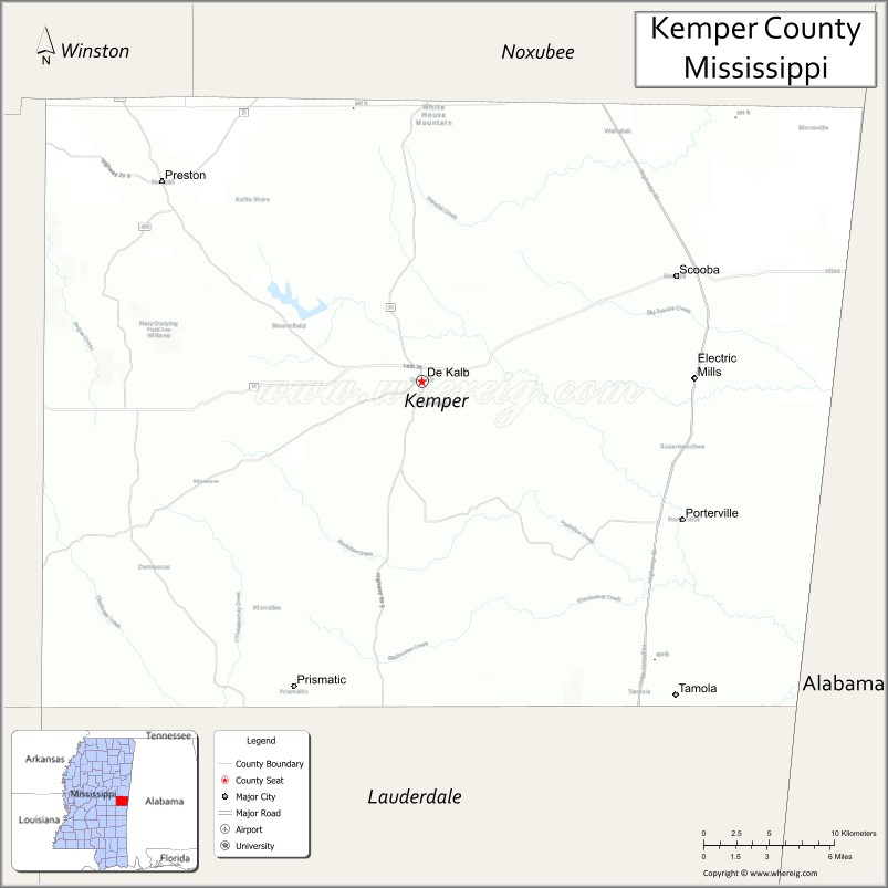
About Kemper County Map, Mississippi: The map showing the county boundary, county seat, major cities, highways, water bodies and neighbouring counties.
Other Mississippi Maps & Info
Kemper County, Mississippi
Kemper County is a county located in the U.S. state of Mississippi. It's county seat is De Kalb. As per 2020 census, the population of Kemper County is 8829 people and population density is square miles. According to the United States Census Bureau, the county has a total area of 766 sq mi (1,984 km2). Kemper County was established on 1833.
Kemper County Facts
| Continent | North America |
| Country | United States |
| State | Mississippi |
| County Seat | De Kalb |
| Largest City/Town | De Kalb |
| Established | 1833 |
| Total Area | 767 sq mi (1,986 sq km) |
| Land Area | 766 sq mi (1,984 sq km) |
| Water Area | 1 sq mi (2.6 sq km) |
| Population | 9,534 (Census 2020) |
| Population Density | 12.4 people per sq mi |
| Time Zone | Central Time Zone |
| Major Highways | U.S. Route 45, Mississippi Highway 16, Mississippi Highway 39 |
| Major Rivers | Sucarnoochee River, Chickasawhay River nearby watershed |
| Neighboring Counties | Noxubee County, Lauderdale County, Winston County, Neshoba County, Sumter County (Alabama) |
| Famous For | Rural Mississippi heritage, coal and energy history, and scenic countryside |
| Top Attractions | De Kalb Historic District, Okatibbee recreation nearby region, and wildlife areas |
| Official Website | Official Website |
About Kemper County, Mississippi
Kemper County is located in east-central Mississippi along the Alabama border and was established in 1833. The county seat and largest town is De Kalb. Kemper County is known for its agricultural traditions, rural landscapes, historical communities, and proximity to scenic outdoor recreation areas.
Cities and Towns in Kemper County, Mississippi
| City/Town | Population (Census 2020) | Latitude & Longitude |
|---|---|---|
| De Kalb (county seat) | 1,778 | 32.7674°N, 88.6542°W |
| Scooba | 744 | 32.8293°N, 88.4850°W |
| Preston nearby region | 1,000 | 32.8010°N, 88.3978°W |
| Lynville nearby region | 600 | 32.6207°N, 88.6014°W |
| Damascus nearby region | 500 | 32.7326°N, 88.7510°W |
Golf Courses in Kemper County, Mississippi
| Golf Course | Location | Latitude & Longitude |
|---|---|---|
| Kemper County Community Golf Area | De Kalb | 32.7708°N, 88.6602°W |
| East Mississippi Regional Golf Facilities nearby region | Nearby region | 32.7791°N, 88.6454°W |
What Are the Major Roads and Highways in Kemper County
Major highways connect Kemper County with eastern Mississippi and western Alabama communities.
- U.S. Route 45 - major north-south transportation corridor through east Mississippi
- Mississippi Highway 16 - east-west highway connecting rural communities and recreation areas
- Mississippi Highway 39 - regional route linking Kemper County with Meridian and surrounding areas
What are the Neighboring Counties of Kemper County
- Noxubee County (north)
- Lauderdale County (south)
- Neshoba County (west)
- Winston County (northwest)
- Sumter County, Alabama (east)
What Are the Top Attractions in Kemper County
The county offers scenic countryside, outdoor recreation, and historic small-town attractions.
- De Kalb Historic District - downtown area featuring historic architecture and Southern heritage sites
- East Mississippi Community College in Scooba - educational institution known for athletics and community programs
- Okatibbee Recreation Nearby Region - boating, fishing, and camping opportunities near regional lakes and forests
- Scenic Countryside Drives - rural routes showcasing forests, farmland, and rolling hills
- Sucarnoochee River Areas - fishing, kayaking, and nature observation destinations
- Historic Churches and Cemeteries - preserved landmarks reflecting local history and culture
- Community Parks and Recreation Facilities - sports fields and family recreation spaces
- Wildlife Observation Areas - natural habitats supporting birds and native Mississippi wildlife
- Outdoor Hunting and Fishing Areas - recreation opportunities throughout rural regions of the county
- Annual Heritage Festivals and Community Events - celebrations highlighting Southern traditions and local culture
Distance from Kemper County to Nearby Cities
The following distances are measured by road (driving).
- De Kalb to Meridian, Mississippi - 35 mi (56 km)
- De Kalb to Columbus, Mississippi - 56 mi (90 km)
- De Kalb to Starkville, Mississippi - 67 mi (108 km)
- De Kalb to Tuscaloosa, Alabama - 94 mi (151 km)
- De Kalb to Birmingham, Alabama - 132 mi (212 km)
- De Kalb to Jackson, Mississippi - 118 mi (190 km)
- De Kalb to Tupelo, Mississippi - 117 mi (188 km)
- De Kalb to Mobile, Alabama - 181 mi (291 km)
- De Kalb to Memphis, Tennessee - 228 mi (367 km)
- De Kalb to Atlanta, Georgia - 245 mi (394 km)
- De Kalb to New Orleans, Louisiana - 236 mi (380 km)
- De Kalb to Dallas, Texas - 489 mi (787 km)
FAQs about Kemper County
Kemper County is located in east-central Mississippi along the Alabama border.
Kemper County had a population of 9,534 according to Census 2020 data.
Kemper County is known for rural Mississippi heritage, coal and energy history, and scenic countryside.
The county is served by U.S. Route 45, Mississippi Highway 16, and Mississippi Highway 39.
Kemper County has local and nearby regional golf facilities serving east Mississippi.
References
- QuickFacts - U.S. Census Bureau
- United States Census Bureau
- Official County Website
- Visit Mississippi
- East Mississippi Community College
- Adams County Map
- Alcorn County Map
- Amite County Map
- Attala County Map
- Benton County Map
- Bolivar County Map
- Calhoun County Map
- Carroll County Map
- Chickasaw County Map
- Choctaw County Map
- Claiborne County Map
- Clarke County Map
- Clay County Map
- Coahoma County Map
- Copiah County Map
- Covington County Map
- DeSoto County Map
- Forrest County Map
- Franklin County Map
- George County Map
- Greene County Map
- Grenada County Map
- Hancock County Map
- Harrison County Map
- Hinds County Map
- Holmes County Map
- Humphreys County Map
- Issaquena County Map
- Itawamba County Map
- Jackson County Map
- Jasper County Map
- Jefferson County Map
- Jefferson Davis County Map
- Jones County Map
- Kemper County Map
- Lafayette County Map
- Lamar County Map
- Lauderdale County Map
- Lawrence County Map
- Leake County Map
- Lee County Map
- Leflore County Map
- Lincoln County Map
- Lowndes County Map
- Madison County Map
- Marion County Map
- Marshall County Map
- Monroe County Map
- Montgomery County Map
- Neshoba County Map
- Newton County Map
- Noxubee County Map
- Oktibbeha County Map
- Panola County Map
- Pearl River County Map
- Perry County Map
- Pike County Map
- Pontotoc County Map
- Prentiss County Map
- Quitman County Map
- Rankin County Map
- Scott County Map
- Sharkey County Map
- Simpson County Map
- Smith County Map
- Stone County Map
- Sunflower County Map
- Tallahatchie County Map
- Tate County Map
- Tippah County Map
- Tishomingo County Map
- Tunica County Map
- Union County Map
- Walthall County Map
- Warren County Map
- Washington County Map
- Wayne County Map
- Webster County Map
- Wilkinson County Map
- Winston County Map
- Yalobusha County Map
- Yazoo County Map
- Alabama Counties
- Alaska boroughs
- Arizona Counties
- Arkansas Counties
- California County Map
- Colorado Counties
- Connecticut Counties
- Delaware Counties
- Florida County Map
- Georgia County Map
- Hawaii Counties
- Idaho Counties
- Illinois Counties
- Indiana Counties
- Iowa Counties
- Kansas Counties
- Kentucky Counties
- Louisiana Counties
- Maine Counties
- Maryland Counties
- Massachusetts Counties
- Michigan County Map
- Minnesota Counties
- Mississippi Counties
- Missouri Counties
- Montana Counties
- Nebraska Counties
- Nevada Counties
- New York Counties
- New Hampshire Counties
- New Jersey Counties
- New Mexico Counties
- North Carolina Counties
- North Dakota Counties
- Ohio County Map
- Oklahoma Counties
- Oregon Counties
- Pennsylvania Counties
- Rhode Island Counties
- South Carolina Counties
- South Dakota Counties
- Map of Tennessee
- Texas County Map
- Utah Counties
- Vermont Counties
- Virginia Counties
- Washington Counties
- West Virginia Counties
- Wisconsin Counties
- Wyoming Counties