Written and Fact-checked by Whereig Editors, Reviewed by Mukesh Kumar| Last Updated On: May 12, 2026
Map of Pearl River County - Pearl River County is a county located in the U.S. state of Mississippi. Pearl River County Map showing cities, highways, important places and water bodies. Get Where is Pearl River County located in the map, major cities in Pearl River county, population, areas, and places of interest.
Map of Pearl River County, Mississippi
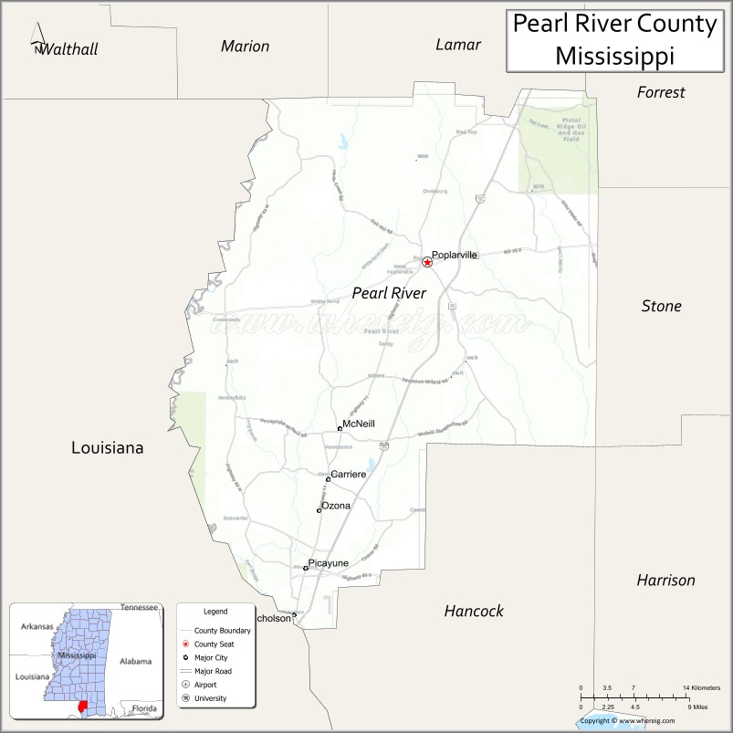
About Pearl River County Map, Mississippi: The map showing the county boundary, county seat, major cities, highways, water bodies and neighbouring counties.
Other Mississippi Maps & Info
Pearl River County, Mississippi
Pearl River County is a county located in the U.S. state of Mississippi. It's county seat is Poplarville. As per 2020 census, the population of Pearl River County is 56503 people and population density is square miles. According to the United States Census Bureau, the county has a total area of 812 sq mi (2,103 km2). Pearl River County was established on 1890.
Pearl River County Facts
| Continent | North America |
| Country | United States |
| State | Mississippi |
| County Seat | Poplarville |
| Largest City/Town | Picayune |
| Established | 1890 |
| Total Area | 819 sq mi (2,121 sq km) |
| Land Area | 811 sq mi (2,100 sq km) |
| Water Area | 8 sq mi (21 sq km) |
| Population | 55,834 (Census 2020) |
| Population Density | 68.8 people per sq mi |
| Time Zone | Central Time Zone |
| Major Highways | Interstate 59, U.S. Route 11, Mississippi Highway 43 |
| Major Rivers | Pearl River, West Hobolochitto Creek |
| Neighboring Counties | Marion County, Hancock County, Stone County, Lamar County, St. Tammany Parish (Louisiana) |
| Famous For | Pearl River waterways, Picayune hospitality, and proximity to the Gulf Coast |
| Top Attractions | Pearl River Wildlife Management Area, Crosby Arboretum, and Downtown Picayune |
| Official Website | Official Website |
About Pearl River County, Mississippi
Pearl River County is located in southern Mississippi along the Louisiana border and was established in 1890. The county seat is Poplarville, while Picayune is the largest city. Pearl River County is known for its scenic river systems, pine forests, outdoor recreation, Gulf Coast accessibility, and welcoming Southern communities.
Cities and Towns in Pearl River County, Mississippi
| City/Town | Population (Census 2020) | Latitude & Longitude |
|---|---|---|
| Picayune | 11,885 | 30.5255°N, 89.6795°W |
| Poplarville (county seat) | 2,894 | 30.8402°N, 89.5345°W |
| Lumberton nearby region | 2,100 | 30.9777°N, 89.4528°W |
| Carriere nearby region | 5,000 | 30.6166°N, 89.6523°W |
| Nicholson nearby region | 3,000 | 30.4752°N, 89.6934°W |
Golf Courses in Pearl River County, Mississippi
| Golf Course | Location | Latitude & Longitude |
|---|---|---|
| Millbrook Golf and Country Club | Picayune | 30.5317°N, 89.6881°W |
| Pine Grove Golf Facilities nearby region | Pearl River region | 30.5183°N, 89.6746°W |
| Gulf Coast Regional Golf Courses nearby region | South Mississippi | 30.5341°N, 89.6817°W |
What Are the Major Roads and Highways in Pearl River County
Major highways connect Pearl River County with the Gulf Coast and New Orleans metropolitan region.
- Interstate 59 - major north-south interstate connecting New Orleans and Hattiesburg
- U.S. Route 11 - historic highway running parallel to Interstate 59
- Mississippi Highway 43 - regional transportation corridor through South Mississippi
What are the Neighboring Counties of Pearl River County
- Marion County (north)
- Lamar County (east)
- Stone County (southeast)
- Hancock County (south)
- St. Tammany Parish, Louisiana (west)
What Are the Top Attractions in Pearl River County
The county offers nature attractions, river recreation, and family-friendly Gulf Coast experiences.
- Pearl River Wildlife Management Area - hunting, fishing, hiking, and wildlife observation destination
- Crosby Arboretum - nationally recognized native plant conservatory and nature center in Picayune
- Downtown Picayune - shopping, restaurants, festivals, and historic Southern charm
- West Hobolochitto Creek Recreation Areas - kayaking, canoeing, and outdoor adventure opportunities
- Pearl River Community College Nearby Region - educational and cultural events destination
- Poplarville Historic District - small-town attractions and historic architecture
- NASA Stennis Space Center Nearby Region - aerospace visitor experiences and educational exhibits
- Scenic Pine Forest Drives - peaceful countryside routes across South Mississippi
- Community Parks and Sports Complexes - family recreation and local events facilities
- Annual Blueberry and Heritage Festivals - celebrations featuring regional food, crafts, and music
Distance from Pearl River County to Nearby Cities
The following distances are measured by road (driving).
- Picayune to Gulfport, Mississippi - 48 mi (77 km)
- Picayune to Biloxi, Mississippi - 58 mi (93 km)
- Picayune to Hattiesburg, Mississippi - 73 mi (117 km)
- Picayune to New Orleans, Louisiana - 52 mi (84 km)
- Picayune to Baton Rouge, Louisiana - 116 mi (187 km)
- Picayune to Mobile, Alabama - 112 mi (180 km)
- Picayune to Jackson, Mississippi - 109 mi (175 km)
- Picayune to Birmingham, Alabama - 248 mi (399 km)
- Picayune to Houston, Texas - 351 mi (565 km)
- Picayune to Atlanta, Georgia - 391 mi (629 km)
- Picayune to Dallas, Texas - 487 mi (784 km)
- Picayune to Memphis, Tennessee - 389 mi (626 km)
FAQs about Pearl River County
Pearl River County is located in southern Mississippi along the Louisiana border.
Pearl River County had a population of 55,834 according to Census 2020 data.
Pearl River County is known for Pearl River waterways, Picayune hospitality, and proximity to the Gulf Coast.
The county is served by Interstate 59, U.S. Route 11, and Mississippi Highway 43.
Yes, Pearl River County has golf facilities including Millbrook Golf and Country Club and nearby Gulf Coast golf courses.
References
- QuickFacts - U.S. Census Bureau
- United States Census Bureau
- Official County Website
- Crosby Arboretum
- Visit Mississippi
- Adams County Map
- Alcorn County Map
- Amite County Map
- Attala County Map
- Benton County Map
- Bolivar County Map
- Calhoun County Map
- Carroll County Map
- Chickasaw County Map
- Choctaw County Map
- Claiborne County Map
- Clarke County Map
- Clay County Map
- Coahoma County Map
- Copiah County Map
- Covington County Map
- DeSoto County Map
- Forrest County Map
- Franklin County Map
- George County Map
- Greene County Map
- Grenada County Map
- Hancock County Map
- Harrison County Map
- Hinds County Map
- Holmes County Map
- Humphreys County Map
- Issaquena County Map
- Itawamba County Map
- Jackson County Map
- Jasper County Map
- Jefferson County Map
- Jefferson Davis County Map
- Jones County Map
- Kemper County Map
- Lafayette County Map
- Lamar County Map
- Lauderdale County Map
- Lawrence County Map
- Leake County Map
- Lee County Map
- Leflore County Map
- Lincoln County Map
- Lowndes County Map
- Madison County Map
- Marion County Map
- Marshall County Map
- Monroe County Map
- Montgomery County Map
- Neshoba County Map
- Newton County Map
- Noxubee County Map
- Oktibbeha County Map
- Panola County Map
- Pearl River County Map
- Perry County Map
- Pike County Map
- Pontotoc County Map
- Prentiss County Map
- Quitman County Map
- Rankin County Map
- Scott County Map
- Sharkey County Map
- Simpson County Map
- Smith County Map
- Stone County Map
- Sunflower County Map
- Tallahatchie County Map
- Tate County Map
- Tippah County Map
- Tishomingo County Map
- Tunica County Map
- Union County Map
- Walthall County Map
- Warren County Map
- Washington County Map
- Wayne County Map
- Webster County Map
- Wilkinson County Map
- Winston County Map
- Yalobusha County Map
- Yazoo County Map
- Alabama Counties
- Alaska boroughs
- Arizona Counties
- Arkansas Counties
- California County Map
- Colorado Counties
- Connecticut Counties
- Delaware Counties
- Florida County Map
- Georgia County Map
- Hawaii Counties
- Idaho Counties
- Illinois Counties
- Indiana Counties
- Iowa Counties
- Kansas Counties
- Kentucky Counties
- Louisiana Counties
- Maine Counties
- Maryland Counties
- Massachusetts Counties
- Michigan County Map
- Minnesota Counties
- Mississippi Counties
- Missouri Counties
- Montana Counties
- Nebraska Counties
- Nevada Counties
- New York Counties
- New Hampshire Counties
- New Jersey Counties
- New Mexico Counties
- North Carolina Counties
- North Dakota Counties
- Ohio County Map
- Oklahoma Counties
- Oregon Counties
- Pennsylvania Counties
- Rhode Island Counties
- South Carolina Counties
- South Dakota Counties
- Map of Tennessee
- Texas County Map
- Utah Counties
- Vermont Counties
- Virginia Counties
- Washington Counties
- West Virginia Counties
- Wisconsin Counties
- Wyoming Counties