Written and Fact-checked by Whereig Editors, Reviewed by Mukesh Kumar| Last Updated On: May 12, 2026
Map of Perry County - Perry County is a county located in the U.S. state of Mississippi. Perry County Map showing cities, highways, important places and water bodies. Get Where is Perry County located in the map, major cities in Perry county, population, areas, and places of interest.
Map of Perry County, Mississippi
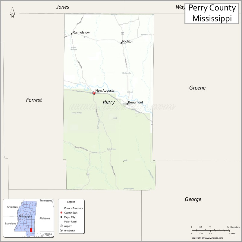
About Perry County Map, Mississippi: The map showing the county boundary, county seat, major cities, highways, water bodies and neighbouring counties.
Other Mississippi Maps & Info
Perry County, Mississippi
Perry County is a county located in the U.S. state of Mississippi. It's county seat is New Augusta. As per 2020 census, the population of Perry County is 11571 people and population density is square miles. According to the United States Census Bureau, the county has a total area of 647 sq mi (1,676 km2). Perry County was established on 1820.
Perry County Facts
| Continent | North America |
| Country | United States |
| State | Mississippi |
| County Seat | New Augusta |
| Largest City/Town | Richton |
| Established | 1820 |
| Total Area | 650 sq mi (1,684 sq km) |
| Land Area | 647 sq mi (1,676 sq km) |
| Water Area | 3 sq mi (8 sq km) |
| Population | 11,552 (Census 2020) |
| Population Density | 17.9 people per sq mi |
| Time Zone | Central Time Zone |
| Major Highways | U.S. Route 98, Mississippi Highway 42, Mississippi Highway 15 |
| Major Rivers | Leaf River, Black Creek |
| Neighboring Counties | Greene County, Forrest County, Jones County, Wayne County, George County |
| Famous For | De Soto National Forest, outdoor recreation, and South Mississippi pine forests |
| Top Attractions | Black Creek Wilderness, De Soto National Forest, and Old Augusta Historic Area |
| Official Website | Official Website |
About Perry County, Mississippi
Perry County is located in southeastern Mississippi and was established in 1820. The county seat is New Augusta, while Richton is the largest town. Perry County is known for its extensive pine forests, wilderness recreation, scenic waterways, and strong ties to the timber industry of South Mississippi.
Cities and Towns in Perry County, Mississippi
| City/Town | Population (Census 2020) | Latitude & Longitude |
|---|---|---|
| Richton | 1,038 | 31.3496°N, 88.9348°W |
| New Augusta (county seat) | 554 | 31.1963°N, 89.0362°W |
| Beaumont | 910 | 31.1696°N, 88.9217°W |
| Old Augusta nearby region | 400 | 31.1765°N, 89.0321°W |
| Janice nearby region | 500 | 31.0797°N, 89.0425°W |
Golf Courses in Perry County, Mississippi
| Golf Course | Location | Latitude & Longitude |
|---|---|---|
| Hidden Oaks Golf Course nearby region | South Mississippi region | 31.3515°N, 88.9304°W |
| Pine Belt Regional Golf Facilities nearby region | Nearby region | 31.2077°N, 89.0281°W |
| Hattiesburg Area Golf Courses nearby region | Pine Belt area | 31.3195°N, 89.2893°W |
What Are the Major Roads and Highways in Perry County
Major highways connect Perry County with the Pine Belt and Gulf Coast regions of Mississippi.
- U.S. Route 98 - major east-west transportation corridor across southern Mississippi
- Mississippi Highway 42 - regional connector route serving Perry County communities
- Mississippi Highway 15 - important north-south highway through southeastern Mississippi
What are the Neighboring Counties of Perry County
- Jones County (north)
- Wayne County (east)
- George County (south)
- Greene County (southwest)
- Forrest County (west)
What Are the Top Attractions in Perry County
The county offers wilderness recreation, river adventures, and scenic forest landscapes.
- Black Creek Wilderness - nationally recognized wilderness area popular for canoeing, kayaking, and camping
- De Soto National Forest - extensive forest recreation area with hiking, biking, and wildlife observation
- Old Augusta Historic Area - historic settlement site with Southern heritage landmarks
- Leaf River Recreation Areas - fishing, boating, and nature activities throughout the county
- Black Creek Canoe Trails - scenic water trails through protected pine forests and sandbars
- Community Parks and Outdoor Sports Facilities - family-friendly recreation destinations
- Scenic Pine Forest Drives - peaceful countryside routes showcasing South Mississippi landscapes
- Wildlife Management Areas - hunting and birdwatching opportunities in protected natural habitats
- Historic Churches and Community Heritage Sites - preserved local cultural landmarks
- Annual Forestry and Heritage Festivals - celebrations highlighting local traditions and outdoor culture
Distance from Perry County to Nearby Cities
The following distances are measured by road (driving).
- New Augusta to Hattiesburg, Mississippi - 36 mi (58 km)
- New Augusta to Gulfport, Mississippi - 70 mi (113 km)
- New Augusta to Biloxi, Mississippi - 78 mi (126 km)
- New Augusta to Mobile, Alabama - 86 mi (138 km)
- New Augusta to Jackson, Mississippi - 115 mi (185 km)
- New Augusta to New Orleans, Louisiana - 122 mi (196 km)
- New Augusta to Baton Rouge, Louisiana - 174 mi (280 km)
- New Augusta to Birmingham, Alabama - 238 mi (383 km)
- New Augusta to Atlanta, Georgia - 356 mi (573 km)
- New Augusta to Houston, Texas - 386 mi (621 km)
- New Augusta to Dallas, Texas - 520 mi (837 km)
- New Augusta to Memphis, Tennessee - 347 mi (558 km)
FAQs about Perry County
Perry County is located in southeastern Mississippi.
Perry County had a population of 11,552 according to Census 2020 data.
Perry County is known for De Soto National Forest, outdoor recreation, and South Mississippi pine forests.
The county is served by U.S. Route 98, Mississippi Highway 42, and Mississippi Highway 15.
Perry County has nearby regional golf facilities serving the Pine Belt and South Mississippi regions.
References
- QuickFacts - U.S. Census Bureau
- United States Census Bureau
- Official County Website
- De Soto National Forest
- Mississippi Department of Wildlife, Fisheries, and Parks
- Adams County Map
- Alcorn County Map
- Amite County Map
- Attala County Map
- Benton County Map
- Bolivar County Map
- Calhoun County Map
- Carroll County Map
- Chickasaw County Map
- Choctaw County Map
- Claiborne County Map
- Clarke County Map
- Clay County Map
- Coahoma County Map
- Copiah County Map
- Covington County Map
- DeSoto County Map
- Forrest County Map
- Franklin County Map
- George County Map
- Greene County Map
- Grenada County Map
- Hancock County Map
- Harrison County Map
- Hinds County Map
- Holmes County Map
- Humphreys County Map
- Issaquena County Map
- Itawamba County Map
- Jackson County Map
- Jasper County Map
- Jefferson County Map
- Jefferson Davis County Map
- Jones County Map
- Kemper County Map
- Lafayette County Map
- Lamar County Map
- Lauderdale County Map
- Lawrence County Map
- Leake County Map
- Lee County Map
- Leflore County Map
- Lincoln County Map
- Lowndes County Map
- Madison County Map
- Marion County Map
- Marshall County Map
- Monroe County Map
- Montgomery County Map
- Neshoba County Map
- Newton County Map
- Noxubee County Map
- Oktibbeha County Map
- Panola County Map
- Pearl River County Map
- Perry County Map
- Pike County Map
- Pontotoc County Map
- Prentiss County Map
- Quitman County Map
- Rankin County Map
- Scott County Map
- Sharkey County Map
- Simpson County Map
- Smith County Map
- Stone County Map
- Sunflower County Map
- Tallahatchie County Map
- Tate County Map
- Tippah County Map
- Tishomingo County Map
- Tunica County Map
- Union County Map
- Walthall County Map
- Warren County Map
- Washington County Map
- Wayne County Map
- Webster County Map
- Wilkinson County Map
- Winston County Map
- Yalobusha County Map
- Yazoo County Map
- Alabama Counties
- Alaska boroughs
- Arizona Counties
- Arkansas Counties
- California County Map
- Colorado Counties
- Connecticut Counties
- Delaware Counties
- Florida County Map
- Georgia County Map
- Hawaii Counties
- Idaho Counties
- Illinois Counties
- Indiana Counties
- Iowa Counties
- Kansas Counties
- Kentucky Counties
- Louisiana Counties
- Maine Counties
- Maryland Counties
- Massachusetts Counties
- Michigan County Map
- Minnesota Counties
- Mississippi Counties
- Missouri Counties
- Montana Counties
- Nebraska Counties
- Nevada Counties
- New York Counties
- New Hampshire Counties
- New Jersey Counties
- New Mexico Counties
- North Carolina Counties
- North Dakota Counties
- Ohio County Map
- Oklahoma Counties
- Oregon Counties
- Pennsylvania Counties
- Rhode Island Counties
- South Carolina Counties
- South Dakota Counties
- Map of Tennessee
- Texas County Map
- Utah Counties
- Vermont Counties
- Virginia Counties
- Washington Counties
- West Virginia Counties
- Wisconsin Counties
- Wyoming Counties