Written and Fact-checked by Whereig Editors, Reviewed by Mukesh Kumar| Last Updated On: May 12, 2026
Map of Pontotoc County - Pontotoc County is a county located in the U.S. state of Mississippi. Pontotoc County Map showing cities, highways, important places and water bodies. Get Where is Pontotoc County located in the map, major cities in Pontotoc county, population, areas, and places of interest.
Map of Pontotoc County, Mississippi
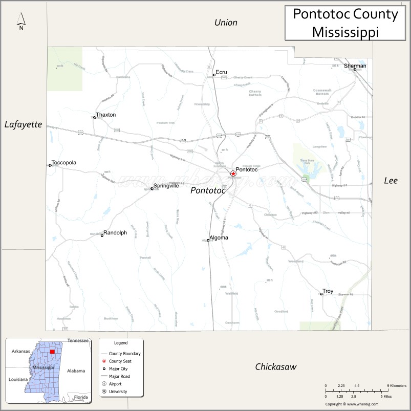
About Pontotoc County Map, Mississippi: The map showing the county boundary, county seat, major cities, highways, water bodies and neighbouring counties.
Other Mississippi Maps & Info
Pontotoc County, Mississippi
Pontotoc County is a county located in the U.S. state of Mississippi. It's county seat is Pontotoc. As per 2020 census, the population of Pontotoc County is 31445 people and population density is square miles. According to the United States Census Bureau, the county has a total area of 497 sq mi (1,287 km2). Pontotoc County was established on 1836.
Pontotoc County Facts
| Continent | North America |
| Country | United States |
| State | Mississippi |
| County Seat | Pontotoc |
| Largest City/Town | Pontotoc |
| Established | 1836 |
| Total Area | 502 sq mi (1,300 sq km) |
| Land Area | 497 sq mi (1,287 sq km) |
| Water Area | 5 sq mi (13 sq km) |
| Population | 31,076 (Census 2020) |
| Population Density | 63 people per sq mi |
| Time Zone | Central Time Zone (CST/CDT) |
| Major Highways | U.S. Route 45, Mississippi Highway 6, Mississippi Highway 9, Mississippi Highway 15, Natchez Trace Parkway |
| Major Rivers | Little Tallahatchie River |
| Neighboring Counties | Union County, Lee County, Chickasaw County, Calhoun County, Lafayette County |
| Famous For | Natchez Trace Parkway, historic downtown Pontotoc, and North Mississippi outdoor recreation |
| Top Attractions | Natchez Trace Parkway, Tanglefoot Trail, Pontotoc Historic District, Trace State Park, Howard Stafford Park |
| Official Website | Official Website |
About Pontotoc County, Mississippi
Pontotoc County is located in the northeastern part of Mississippi in the southern United States and was established in 1836. The county seat and largest city is Pontotoc. The county is known for its rolling hills, forested landscapes, historic sites, and recreational trails that attract visitors across North Mississippi.
Cities and Towns in Pontotoc County, Mississippi
| City/Town | Population (Census 2020) | Latitude & Longitude |
|---|---|---|
| Pontotoc (county seat) | 5,640 | 34.2479°N, 89.0126°W |
| Ecru | 895 | 34.3534°N, 89.0264°W |
| Sherman | 4,657 | 34.3584°N, 88.8403°W |
| Algoma | 1,033 | 34.1765°N, 89.0317°W |
| Bankhead (CDP) | 405 | 34.1125°N, 88.9971°W |
| Toccopola | 246 | 34.2567°N, 88.9962°W |
| Troy (CDP) | 287 | 34.3318°N, 89.1044°W |
Golf Courses in Pontotoc County, Mississippi
| Golf Course | Location | Latitude & Longitude |
|---|---|---|
| Pontotoc Country Club | Pontotoc | 34.2337°N, 89.0252°W |
| Dogwoods Golf Course | Pontotoc | 34.2751°N, 89.0468°W |
What Are the Major Roads and Highways in Pontotoc County, Mississippi
Major highways connect the county to nearby regions and cities.
- U.S. Route 45 - connects the county with Tupelo and Booneville
- Mississippi Highway 6 - runs east-west through Pontotoc County linking Oxford and Tupelo
- Mississippi Highway 9 - connects Pontotoc with northern and central Mississippi communities
- Mississippi Highway 15 - serves local communities and connects to New Albany and Houston
- Natchez Trace Parkway - scenic historic route crossing the western part of the county
What are the Neighboring Counties of Pontotoc County
- Union County (north)
- Lee County (east)
- Chickasaw County (southeast)
- Calhoun County (southwest)
- Lafayette County (west)
What Are the Top Attractions in Pontotoc County, Mississippi
The county offers a mix of natural and cultural attractions.
- Natchez Trace Parkway - scenic historic driving route with hiking areas and overlooks
- Tanglefoot Trail - popular biking and walking trail stretching across North Mississippi
- Trace State Park - state park with camping, fishing, cabins, and boating opportunities
- Pontotoc Historic District - historic downtown area with preserved architecture and local shops
- Howard Stafford Park - community park with sports fields and recreation facilities
- Pontotoc County Historical Society Museum - local museum featuring county history exhibits
- Little Tallahatchie River - scenic river area popular for outdoor recreation
- Ecru Community Park - public park with picnic and sports facilities
- Ingomar Mounds Area - archaeological and historical site linked to Native American history
- North Mississippi Hills Region - rolling landscapes and scenic countryside throughout the county
Distance from Pontotoc County to Nearby Cities
The following distances are measured by road (driving).
- Pontotoc to Tupelo (Lee County), Mississippi - 18 mi (29 km)
- Pontotoc to Oxford (Lafayette County), Mississippi - 38 mi (61 km)
- Pontotoc to New Albany (Union County), Mississippi - 32 mi (51 km)
- Pontotoc to Houston (Chickasaw County), Mississippi - 33 mi (53 km)
- Pontotoc to Booneville (Prentiss County), Mississippi - 33 mi (53 km)
- Pontotoc to Starkville (Oktibbeha County), Mississippi - 74 mi (119 km)
- Pontotoc to Columbus (Lowndes County), Mississippi - 89 mi (143 km)
- Pontotoc to Memphis (Shelby County), Tennessee - 103 mi (166 km)
- Pontotoc to Jackson (Hinds County), Mississippi - 167 mi (269 km)
- Pontotoc to Greenwood (Leflore County), Mississippi - 97 mi (156 km)
- Pontotoc to Ripley (Tippah County), Mississippi - 42 mi (68 km)
- Pontotoc to Amory (Monroe County), Mississippi - 61 mi (98 km)
- Pontotoc to Water Valley (Yalobusha County), Mississippi - 49 mi (79 km)
FAQs about Pontotoc County
Pontotoc County is located in northeastern Mississippi in the North Mississippi hills region.
Pontotoc County had a population of 31,076 according to the 2020 United States Census.
Pontotoc County is known for the Natchez Trace Parkway, Tanglefoot Trail, and scenic outdoor recreation areas.
The county is served by U.S. Route 45, Mississippi Highway 6, Mississippi Highway 9, and the Natchez Trace Parkway.
Yes, Pontotoc County includes golf facilities such as Pontotoc Country Club and Dogwoods Golf Course.
References
- QuickFacts - U.S. Census Bureau
- United States Census Bureau
- United States Geological Survey (USGS)
- National Geodetic Survey
- Official County Website
- Adams County Map
- Alcorn County Map
- Amite County Map
- Attala County Map
- Benton County Map
- Bolivar County Map
- Calhoun County Map
- Carroll County Map
- Chickasaw County Map
- Choctaw County Map
- Claiborne County Map
- Clarke County Map
- Clay County Map
- Coahoma County Map
- Copiah County Map
- Covington County Map
- DeSoto County Map
- Forrest County Map
- Franklin County Map
- George County Map
- Greene County Map
- Grenada County Map
- Hancock County Map
- Harrison County Map
- Hinds County Map
- Holmes County Map
- Humphreys County Map
- Issaquena County Map
- Itawamba County Map
- Jackson County Map
- Jasper County Map
- Jefferson County Map
- Jefferson Davis County Map
- Jones County Map
- Kemper County Map
- Lafayette County Map
- Lamar County Map
- Lauderdale County Map
- Lawrence County Map
- Leake County Map
- Lee County Map
- Leflore County Map
- Lincoln County Map
- Lowndes County Map
- Madison County Map
- Marion County Map
- Marshall County Map
- Monroe County Map
- Montgomery County Map
- Neshoba County Map
- Newton County Map
- Noxubee County Map
- Oktibbeha County Map
- Panola County Map
- Pearl River County Map
- Perry County Map
- Pike County Map
- Pontotoc County Map
- Prentiss County Map
- Quitman County Map
- Rankin County Map
- Scott County Map
- Sharkey County Map
- Simpson County Map
- Smith County Map
- Stone County Map
- Sunflower County Map
- Tallahatchie County Map
- Tate County Map
- Tippah County Map
- Tishomingo County Map
- Tunica County Map
- Union County Map
- Walthall County Map
- Warren County Map
- Washington County Map
- Wayne County Map
- Webster County Map
- Wilkinson County Map
- Winston County Map
- Yalobusha County Map
- Yazoo County Map
- Alabama Counties
- Alaska boroughs
- Arizona Counties
- Arkansas Counties
- California County Map
- Colorado Counties
- Connecticut Counties
- Delaware Counties
- Florida County Map
- Georgia County Map
- Hawaii Counties
- Idaho Counties
- Illinois Counties
- Indiana Counties
- Iowa Counties
- Kansas Counties
- Kentucky Counties
- Louisiana Counties
- Maine Counties
- Maryland Counties
- Massachusetts Counties
- Michigan County Map
- Minnesota Counties
- Mississippi Counties
- Missouri Counties
- Montana Counties
- Nebraska Counties
- Nevada Counties
- New York Counties
- New Hampshire Counties
- New Jersey Counties
- New Mexico Counties
- North Carolina Counties
- North Dakota Counties
- Ohio County Map
- Oklahoma Counties
- Oregon Counties
- Pennsylvania Counties
- Rhode Island Counties
- South Carolina Counties
- South Dakota Counties
- Map of Tennessee
- Texas County Map
- Utah Counties
- Vermont Counties
- Virginia Counties
- Washington Counties
- West Virginia Counties
- Wisconsin Counties
- Wyoming Counties