Written and Fact-checked by Whereig Editors, Reviewed by Mukesh Kumar| Last Updated On: May 12, 2026
Map of Lawrence County - Lawrence County is a county located in the U.S. state of Mississippi. Lawrence County Map showing cities, highways, important places and water bodies. Get Where is Lawrence County located in the map, major cities in Lawrence county, population, areas, and places of interest.
Map of Lawrence County, Mississippi
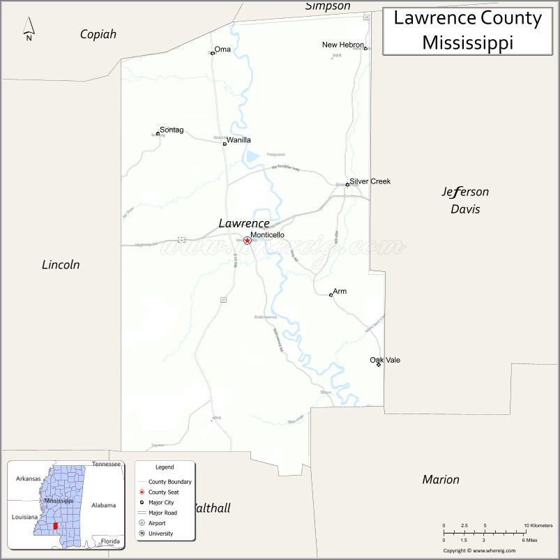
About Lawrence County Map, Mississippi: The map showing the county boundary, county seat, major cities, highways, water bodies and neighbouring counties.
Other Mississippi Maps & Info
Lawrence County, Mississippi
Lawrence County is a county located in the U.S. state of Mississippi. It's county seat is Monticello. As per 2020 census, the population of Lawrence County is 11812 people and population density is square miles. According to the United States Census Bureau, the county has a total area of 431 sq mi (1,116 km2). Lawrence County was established on 1814.
Lawrence County Facts
| Continent | North America |
| Country | United States |
| State | Mississippi |
| County Seat | Monticello |
| Largest City/Town | Monticello |
| Established | 1814 |
| Total Area | 431 sq mi (1,116 sq km) |
| Land Area | 431 sq mi (1,116 sq km) |
| Water Area | 1 sq mi (2.6 sq km) |
| Population | 12,458 (Census 2020) |
| Population Density | 28.9 people per sq mi |
| Time Zone | Central Time Zone |
| Major Highways | U.S. Route 84, Mississippi Highway 27, Mississippi Highway 43 |
| Major Rivers | Pearl River, Strong River |
| Neighboring Counties | Simpson County, Jefferson Davis County, Marion County, Lincoln County, Copiah County |
| Famous For | Pearl River recreation, forestry, and historic Southern small towns |
| Top Attractions | Pearl River recreation areas, Monticello Historic District, and Lake Walthall |
| Official Website | Official Website |
About Lawrence County, Mississippi
Lawrence County is located in south-central Mississippi and was established in 1814. The county seat and largest town is Monticello. Lawrence County is known for its scenic river landscapes, pine forests, outdoor recreation, and strong agricultural and forestry traditions.
Cities and Towns in Lawrence County, Mississippi
| City/Town | Population (Census 2020) | Latitude & Longitude |
|---|---|---|
| Monticello (county seat) | 1,428 | 31.5530°N, 90.1084°W |
| New Hebron | 447 | 31.7243°N, 89.9137°W |
| Silver Creek | 296 | 31.4668°N, 90.0045°W |
| Oak Vale nearby region | 700 | 31.6437°N, 89.9973°W |
| Topeka nearby region | 500 | 31.6152°N, 90.1859°W |
Golf Courses in Lawrence County, Mississippi
| Golf Course | Location | Latitude & Longitude |
|---|---|---|
| Monticello Community Golf Area | Monticello | 31.5597°N, 90.1146°W |
| South Mississippi Regional Golf Facilities nearby region | Nearby region | 31.5484°N, 90.1027°W |
What Are the Major Roads and Highways in Lawrence County
Major highways connect Lawrence County with central and southern Mississippi communities.
- U.S. Route 84 - major east-west highway across southern Mississippi
- Mississippi Highway 27 - north-south corridor linking rural communities and recreation areas
- Mississippi Highway 43 - important regional route through forest and agricultural regions
What are the Neighboring Counties of Lawrence County
- Simpson County (north)
- Copiah County (northwest)
- Lincoln County (west)
- Marion County (south)
- Jefferson Davis County (east)
What Are the Top Attractions in Lawrence County
The county offers river recreation, scenic countryside, and historic Southern attractions.
- Pearl River Recreation Areas - fishing, kayaking, boating, and wildlife observation opportunities
- Monticello Historic District - downtown area with historic architecture and local businesses
- Lake Walthall - outdoor recreation destination for fishing, camping, and boating
- Strong River Scenic Areas - peaceful natural settings popular for photography and nature exploration
- Scenic Pine Forest Drives - countryside routes showcasing Mississippi timber landscapes
- Lawrence County Civic Center and Parks - community recreation and sports facilities
- Historic Churches and Heritage Sites - preserved landmarks reflecting local Southern culture
- Outdoor Hunting and Wildlife Areas - recreation opportunities throughout rural forest regions
- Annual Community Festivals and Heritage Events - celebrations highlighting local traditions and culture
- Nature Observation and Birdwatching Areas - habitats supporting native Mississippi wildlife
Distance from Lawrence County to Nearby Cities
The following distances are measured by road (driving).
- Monticello to Hattiesburg, Mississippi - 52 mi (84 km)
- Monticello to Jackson, Mississippi - 72 mi (116 km)
- Monticello to Brookhaven, Mississippi - 31 mi (50 km)
- Monticello to Gulfport, Mississippi - 103 mi (166 km)
- Monticello to Biloxi, Mississippi - 110 mi (177 km)
- Monticello to Baton Rouge, Louisiana - 105 mi (169 km)
- Monticello to New Orleans, Louisiana - 126 mi (203 km)
- Monticello to Mobile, Alabama - 146 mi (235 km)
- Monticello to Birmingham, Alabama - 255 mi (410 km)
- Monticello to Memphis, Tennessee - 276 mi (444 km)
- Monticello to Houston, Texas - 344 mi (554 km)
- Monticello to Atlanta, Georgia - 378 mi (608 km)
FAQs about Lawrence County
Lawrence County is located in south-central Mississippi.
Lawrence County had a population of 12,458 according to Census 2020 data.
Lawrence County is known for Pearl River recreation, forestry, and historic Southern small towns.
The county is served by U.S. Route 84, Mississippi Highway 27, and Mississippi Highway 43.
Lawrence County has local and nearby regional golf facilities serving south-central Mississippi.
References
- QuickFacts - U.S. Census Bureau
- United States Census Bureau
- Official County Website
- Visit Mississippi
- Mississippi Department of Wildlife, Fisheries, and Parks
- Adams County Map
- Alcorn County Map
- Amite County Map
- Attala County Map
- Benton County Map
- Bolivar County Map
- Calhoun County Map
- Carroll County Map
- Chickasaw County Map
- Choctaw County Map
- Claiborne County Map
- Clarke County Map
- Clay County Map
- Coahoma County Map
- Copiah County Map
- Covington County Map
- DeSoto County Map
- Forrest County Map
- Franklin County Map
- George County Map
- Greene County Map
- Grenada County Map
- Hancock County Map
- Harrison County Map
- Hinds County Map
- Holmes County Map
- Humphreys County Map
- Issaquena County Map
- Itawamba County Map
- Jackson County Map
- Jasper County Map
- Jefferson County Map
- Jefferson Davis County Map
- Jones County Map
- Kemper County Map
- Lafayette County Map
- Lamar County Map
- Lauderdale County Map
- Lawrence County Map
- Leake County Map
- Lee County Map
- Leflore County Map
- Lincoln County Map
- Lowndes County Map
- Madison County Map
- Marion County Map
- Marshall County Map
- Monroe County Map
- Montgomery County Map
- Neshoba County Map
- Newton County Map
- Noxubee County Map
- Oktibbeha County Map
- Panola County Map
- Pearl River County Map
- Perry County Map
- Pike County Map
- Pontotoc County Map
- Prentiss County Map
- Quitman County Map
- Rankin County Map
- Scott County Map
- Sharkey County Map
- Simpson County Map
- Smith County Map
- Stone County Map
- Sunflower County Map
- Tallahatchie County Map
- Tate County Map
- Tippah County Map
- Tishomingo County Map
- Tunica County Map
- Union County Map
- Walthall County Map
- Warren County Map
- Washington County Map
- Wayne County Map
- Webster County Map
- Wilkinson County Map
- Winston County Map
- Yalobusha County Map
- Yazoo County Map
- Alabama Counties
- Alaska boroughs
- Arizona Counties
- Arkansas Counties
- California County Map
- Colorado Counties
- Connecticut Counties
- Delaware Counties
- Florida County Map
- Georgia County Map
- Hawaii Counties
- Idaho Counties
- Illinois Counties
- Indiana Counties
- Iowa Counties
- Kansas Counties
- Kentucky Counties
- Louisiana Counties
- Maine Counties
- Maryland Counties
- Massachusetts Counties
- Michigan County Map
- Minnesota Counties
- Mississippi Counties
- Missouri Counties
- Montana Counties
- Nebraska Counties
- Nevada Counties
- New York Counties
- New Hampshire Counties
- New Jersey Counties
- New Mexico Counties
- North Carolina Counties
- North Dakota Counties
- Ohio County Map
- Oklahoma Counties
- Oregon Counties
- Pennsylvania Counties
- Rhode Island Counties
- South Carolina Counties
- South Dakota Counties
- Map of Tennessee
- Texas County Map
- Utah Counties
- Vermont Counties
- Virginia Counties
- Washington Counties
- West Virginia Counties
- Wisconsin Counties
- Wyoming Counties