Written and Fact-checked by Whereig Editors, Reviewed by Mukesh Kumar| Last Updated On: May 12, 2026
Map of Benton County - Benton County is a county located in the U.S. state of Mississippi. Benton County Map showing cities, highways, important places and water bodies. Get Where is Benton County located in the map, major cities in Benton county, population, areas, and places of interest.
Map of Benton County, Mississippi
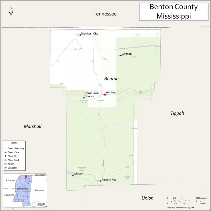
About Benton County Map, Mississippi: The map showing the county boundary, county seat, major cities, highways, water bodies and neighbouring counties.
Other Mississippi Maps & Info
Benton County, Mississippi
Benton County is a county located in the U.S. state of Mississippi. It's county seat is Ashland. As per 2020 census, the population of Benton County is 7646 people and population density is square miles. According to the United States Census Bureau, the county has a total area of 407 sq mi (1,054 km2). Benton County was established on 1870.
Benton County Facts
| Continent | North America |
| Country | United States |
| State | Mississippi |
| County Seat | Ashland |
| Largest City/Town | Ashland |
| Established | 1836 |
| Total Area | 409 sq mi (1,059 sq km) |
| Land Area | 407 sq mi (1,054 sq km) |
| Water Area | 2 sq mi (5.2 sq km) |
| Population | 8,192 (Census 2020) |
| Population Density | 20.1 people per sq mi |
| Time Zone | Central Time Zone |
| Major Highways | Mississippi Highway 4, Mississippi Highway 5, Mississippi Highway 370 |
| Major Rivers | Wolf River nearby watershed |
| Neighboring Counties | Tippah County, Marshall County, Lafayette County, Union County, Hardeman County (Tennessee) |
| Famous For | Rolling hills, rural heritage, and scenic North Mississippi countryside |
| Top Attractions | Ashland Historic District, Holly Springs National Forest nearby region, and Tippah River recreation areas |
| Official Website | Official Website |
About Benton County, Mississippi
Benton County is located in northern Mississippi near the Tennessee border and was established in 1836. The county seat and largest town is Ashland. The county is known for its scenic rolling hills, agricultural traditions, forests, and peaceful rural communities characteristic of North Mississippi.
Cities and Towns in Benton County, Mississippi
| City/Town | Population (Census 2020) | Latitude & Longitude |
|---|---|---|
| Ashland (county seat) | 551 | 34.8320°N, 89.1781°W |
| Hickory Flat nearby region | 600 | 34.6162°N, 89.1865°W |
| Snow Lake Shores nearby region | 300 | 34.7925°N, 89.3601°W |
Golf Courses in Benton County, Mississippi
| Golf Course | Location | Latitude & Longitude |
|---|---|---|
| North Mississippi Country Club nearby region | Near Ashland | 34.8384°N, 89.1837°W |
| Holly Springs Area Golf Facilities nearby region | Nearby region | 34.7698°N, 89.4481°W |
What Are the Major Roads and Highways in Benton County, Mississippi
Major highways connect Benton County with North Mississippi and nearby Tennessee communities.
- Mississippi Highway 4 - east-west route crossing northern Mississippi
- Mississippi Highway 5 - regional north-south highway serving rural communities
- Mississippi Highway 370 - local connector route linking towns and countryside areas
What are the Neighboring Counties of Benton County
- Tippah County (east)
- Union County (southeast)
- Lafayette County (south)
- Marshall County (west)
- Hardeman County, Tennessee (north)
What Are the Top Attractions in Benton County, Mississippi
The county offers a combination of natural beauty, outdoor recreation, and historical attractions.
- Ashland Historic District - historic courthouse area featuring classic Southern architecture and local heritage
- Holly Springs National Forest Nearby Region - forest recreation area with hiking, camping, and wildlife observation
- Tippah River Recreation Areas - scenic spots for fishing, kayaking, and outdoor activities
- Snow Lake Shores Nearby Region - peaceful lakeside community with boating and fishing opportunities
- North Mississippi Scenic Drives - countryside routes featuring rolling hills and forest landscapes
- Outdoor Recreation Areas - hunting, hiking, birdwatching, and camping opportunities
- Community Parks and Picnic Areas - family-friendly recreation spaces throughout the county
- Historic Rural Churches and Cemeteries - landmarks reflecting regional history and culture
- Wildlife Observation Areas - habitats supporting deer, birds, and native Mississippi wildlife
- Annual Community Festivals and Heritage Events - celebrations highlighting local traditions and rural culture
Distance from Benton County to Nearby Cities
The following distances are measured by road (driving).
- Ashland to Oxford, Mississippi - 33 mi (53 km)
- Ashland to Tupelo, Mississippi - 56 mi (90 km)
- Ashland to Memphis, Tennessee - 76 mi (122 km)
- Ashland to Corinth, Mississippi - 61 mi (98 km)
- Ashland to Jackson, Tennessee - 98 mi (158 km)
- Ashland to Jackson, Mississippi - 174 mi (280 km)
- Ashland to Birmingham, Alabama - 166 mi (267 km)
- Ashland to Nashville, Tennessee - 215 mi (346 km)
- Ashland to Little Rock, Arkansas - 188 mi (303 km)
- Ashland to New Orleans, Louisiana - 377 mi (607 km)
- Ashland to Atlanta, Georgia - 329 mi (529 km)
- Ashland to St. Louis, Missouri - 321 mi (517 km)
FAQs about Benton County
Benton County is located in northern Mississippi near the Tennessee border.
Benton County had a population of 8,192 according to Census 2020 data.
Benton County is known for rolling hills, rural heritage, and scenic North Mississippi countryside.
The county is served by Mississippi Highway 4, Mississippi Highway 5, and Mississippi Highway 370.
Yes, Benton County has nearby golf facilities and country club recreation areas in the North Mississippi region.
References
- QuickFacts - U.S. Census Bureau
- United States Census Bureau
- United States Forest Service
- Official County Website
- Visit Mississippi
- Adams County Map
- Alcorn County Map
- Amite County Map
- Attala County Map
- Benton County Map
- Bolivar County Map
- Calhoun County Map
- Carroll County Map
- Chickasaw County Map
- Choctaw County Map
- Claiborne County Map
- Clarke County Map
- Clay County Map
- Coahoma County Map
- Copiah County Map
- Covington County Map
- DeSoto County Map
- Forrest County Map
- Franklin County Map
- George County Map
- Greene County Map
- Grenada County Map
- Hancock County Map
- Harrison County Map
- Hinds County Map
- Holmes County Map
- Humphreys County Map
- Issaquena County Map
- Itawamba County Map
- Jackson County Map
- Jasper County Map
- Jefferson County Map
- Jefferson Davis County Map
- Jones County Map
- Kemper County Map
- Lafayette County Map
- Lamar County Map
- Lauderdale County Map
- Lawrence County Map
- Leake County Map
- Lee County Map
- Leflore County Map
- Lincoln County Map
- Lowndes County Map
- Madison County Map
- Marion County Map
- Marshall County Map
- Monroe County Map
- Montgomery County Map
- Neshoba County Map
- Newton County Map
- Noxubee County Map
- Oktibbeha County Map
- Panola County Map
- Pearl River County Map
- Perry County Map
- Pike County Map
- Pontotoc County Map
- Prentiss County Map
- Quitman County Map
- Rankin County Map
- Scott County Map
- Sharkey County Map
- Simpson County Map
- Smith County Map
- Stone County Map
- Sunflower County Map
- Tallahatchie County Map
- Tate County Map
- Tippah County Map
- Tishomingo County Map
- Tunica County Map
- Union County Map
- Walthall County Map
- Warren County Map
- Washington County Map
- Wayne County Map
- Webster County Map
- Wilkinson County Map
- Winston County Map
- Yalobusha County Map
- Yazoo County Map
- Alabama Counties
- Alaska boroughs
- Arizona Counties
- Arkansas Counties
- California County Map
- Colorado Counties
- Connecticut Counties
- Delaware Counties
- Florida County Map
- Georgia County Map
- Hawaii Counties
- Idaho Counties
- Illinois Counties
- Indiana Counties
- Iowa Counties
- Kansas Counties
- Kentucky Counties
- Louisiana Counties
- Maine Counties
- Maryland Counties
- Massachusetts Counties
- Michigan County Map
- Minnesota Counties
- Mississippi Counties
- Missouri Counties
- Montana Counties
- Nebraska Counties
- Nevada Counties
- New York Counties
- New Hampshire Counties
- New Jersey Counties
- New Mexico Counties
- North Carolina Counties
- North Dakota Counties
- Ohio County Map
- Oklahoma Counties
- Oregon Counties
- Pennsylvania Counties
- Rhode Island Counties
- South Carolina Counties
- South Dakota Counties
- Map of Tennessee
- Texas County Map
- Utah Counties
- Vermont Counties
- Virginia Counties
- Washington Counties
- West Virginia Counties
- Wisconsin Counties
- Wyoming Counties