Written and Fact-checked by Whereig Editors, Reviewed by Mukesh Kumar| Last Updated On: May 12, 2026
Map of Leake County - Leake County is a county located in the U.S. state of Mississippi. Leake County Map showing cities, highways, important places and water bodies. Get Where is Leake County located in the map, major cities in Leake county, population, areas, and places of interest.
Map of Leake County, Mississippi
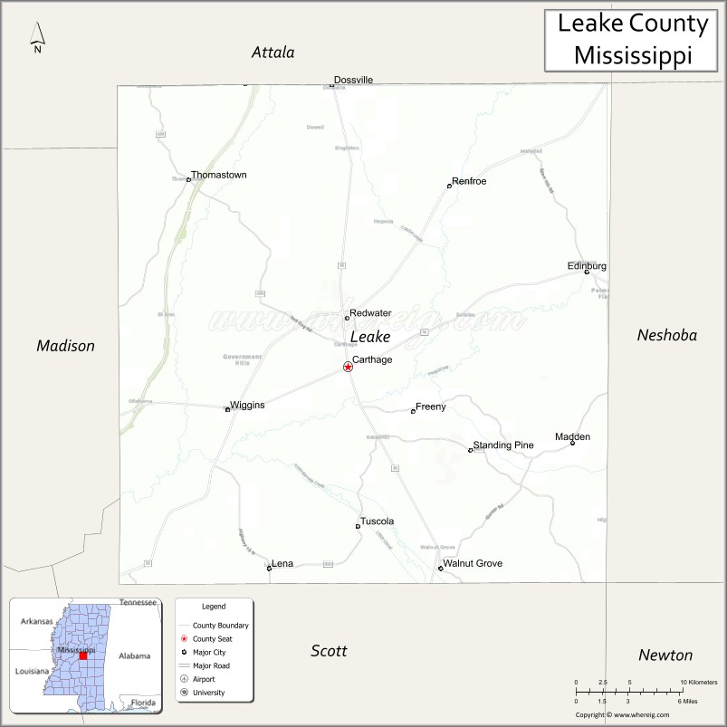
About Leake County Map, Mississippi: The map showing the county boundary, county seat, major cities, highways, water bodies and neighbouring counties.
Other Mississippi Maps & Info
Leake County, Mississippi
Leake County is a county located in the U.S. state of Mississippi. It's county seat is Carthage. As per 2020 census, the population of Leake County is 21196 people and population density is square miles. According to the United States Census Bureau, the county has a total area of 583 sq mi (1,510 km2). Leake County was established on 1833.
Leake County Facts
| Continent | North America |
| Country | United States |
| State | Mississippi |
| County Seat | Carthage |
| Largest City/Town | Carthage |
| Established | 1833 |
| Total Area | 589 sq mi (1,526 sq km) |
| Land Area | 583 sq mi (1,510 sq km) |
| Water Area | 6 sq mi (16 sq km) |
| Population | 21,275 (Census 2020) |
| Population Density | 36.5 people per sq mi |
| Time Zone | Central Time Zone |
| Major Highways | Mississippi Highway 16, Mississippi Highway 25, Mississippi Highway 35 |
| Major Rivers | Pearl River, Yockanookany River |
| Neighboring Counties | Neshoba County, Attala County, Madison County, Scott County, Newton County |
| Famous For | Poultry farming, Pearl River recreation, and historic Carthage |
| Top Attractions | Pearl River Resort nearby region, Carthage Historic District, and Natchez Trace nearby areas |
| Official Website | Official Website |
About Leake County, Mississippi
Leake County is located in central Mississippi and was established in 1833. The county seat and largest city is Carthage. Leake County is known for agriculture, poultry production, scenic river landscapes, and its connections to the nearby Mississippi Choctaw communities and Pearl River region.
Cities and Towns in Leake County, Mississippi
| City/Town | Population (Census 2020) | Latitude & Longitude |
|---|---|---|
| Carthage (county seat) | 4,923 | 32.7326°N, 89.5362°W |
| Sebastopol | 266 | 32.7721°N, 89.3475°W |
| Lena | 258 | 32.5907°N, 89.5928°W |
| Walnut Grove | 698 | 32.5909°N, 89.4581°W |
| Edinburg nearby region | 1,000 | 32.7981°N, 89.3361°W |
| Thomastown nearby region | 600 | 32.8801°N, 89.5253°W |
Golf Courses in Leake County, Mississippi
| Golf Course | Location | Latitude & Longitude |
|---|---|---|
| Leake Country Club | Carthage | 32.7394°N, 89.5411°W |
| Pearl River Resort Golf Nearby Region | Choctaw region | 32.7867°N, 89.1258°W |
| Dancing Rabbit Golf Club nearby region | Choctaw area | 32.7752°N, 89.1284°W |
What Are the Major Roads and Highways in Leake County
Major highways connect Leake County with central Mississippi communities and nearby recreation destinations.
- Mississippi Highway 16 - east-west route linking Carthage with central Mississippi towns
- Mississippi Highway 25 - north-south highway connecting Starkville and Jackson regions
- Mississippi Highway 35 - regional transportation corridor through rural Mississippi
What are the Neighboring Counties of Leake County
- Attala County (north)
- Neshoba County (east)
- Newton County (southeast)
- Scott County (south)
- Madison County (west)
What Are the Top Attractions in Leake County
The county offers river recreation, cultural attractions, and scenic rural Mississippi landscapes.
- Carthage Historic District - downtown area featuring historic buildings and local businesses
- Pearl River Resort Nearby Region - entertainment, gaming, dining, and golf destination operated by the Mississippi Band of Choctaw Indians
- Dancing Rabbit Golf Club Nearby Region - nationally recognized golf destination in the Choctaw area
- Pearl River Recreation Areas - fishing, boating, and nature observation opportunities
- Natchez Trace Nearby Areas - scenic driving routes and historical sites
- Choctaw Cultural Attractions Nearby Region - museums and heritage sites celebrating Native American history
- Leake County Fairgrounds and Community Events - festivals and agricultural gatherings throughout the year
- Scenic Countryside Drives - rolling farmland and forest landscapes across central Mississippi
- Outdoor Hunting and Wildlife Areas - recreation opportunities for sportsmen and nature enthusiasts
- Community Parks and Recreation Facilities - family-friendly spaces for sports and outdoor activities
Distance from Leake County to Nearby Cities
The following distances are measured by road (driving).
- Carthage to Jackson, Mississippi - 58 mi (93 km)
- Carthage to Meridian, Mississippi - 72 mi (116 km)
- Carthage to Starkville, Mississippi - 86 mi (138 km)
- Carthage to Tupelo, Mississippi - 134 mi (216 km)
- Carthage to Hattiesburg, Mississippi - 127 mi (204 km)
- Carthage to Birmingham, Alabama - 177 mi (285 km)
- Carthage to Memphis, Tennessee - 208 mi (335 km)
- Carthage to Mobile, Alabama - 228 mi (367 km)
- Carthage to New Orleans, Louisiana - 232 mi (373 km)
- Carthage to Atlanta, Georgia - 292 mi (470 km)
- Carthage to Dallas, Texas - 470 mi (756 km)
- Carthage to Houston, Texas - 432 mi (695 km)
FAQs about Leake County
Leake County is located in central Mississippi.
Leake County had a population of 21,275 according to Census 2020 data.
Leake County is known for poultry farming, Pearl River recreation, and historic Carthage.
The county is served by Mississippi Highway 16, Mississippi Highway 25, and Mississippi Highway 35.
Yes, Leake County has golf facilities including Leake Country Club and nearby Dancing Rabbit Golf Club.
References
- QuickFacts - U.S. Census Bureau
- United States Census Bureau
- Official County Website
- Pearl River Resort
- Visit Mississippi
- Adams County Map
- Alcorn County Map
- Amite County Map
- Attala County Map
- Benton County Map
- Bolivar County Map
- Calhoun County Map
- Carroll County Map
- Chickasaw County Map
- Choctaw County Map
- Claiborne County Map
- Clarke County Map
- Clay County Map
- Coahoma County Map
- Copiah County Map
- Covington County Map
- DeSoto County Map
- Forrest County Map
- Franklin County Map
- George County Map
- Greene County Map
- Grenada County Map
- Hancock County Map
- Harrison County Map
- Hinds County Map
- Holmes County Map
- Humphreys County Map
- Issaquena County Map
- Itawamba County Map
- Jackson County Map
- Jasper County Map
- Jefferson County Map
- Jefferson Davis County Map
- Jones County Map
- Kemper County Map
- Lafayette County Map
- Lamar County Map
- Lauderdale County Map
- Lawrence County Map
- Leake County Map
- Lee County Map
- Leflore County Map
- Lincoln County Map
- Lowndes County Map
- Madison County Map
- Marion County Map
- Marshall County Map
- Monroe County Map
- Montgomery County Map
- Neshoba County Map
- Newton County Map
- Noxubee County Map
- Oktibbeha County Map
- Panola County Map
- Pearl River County Map
- Perry County Map
- Pike County Map
- Pontotoc County Map
- Prentiss County Map
- Quitman County Map
- Rankin County Map
- Scott County Map
- Sharkey County Map
- Simpson County Map
- Smith County Map
- Stone County Map
- Sunflower County Map
- Tallahatchie County Map
- Tate County Map
- Tippah County Map
- Tishomingo County Map
- Tunica County Map
- Union County Map
- Walthall County Map
- Warren County Map
- Washington County Map
- Wayne County Map
- Webster County Map
- Wilkinson County Map
- Winston County Map
- Yalobusha County Map
- Yazoo County Map
- Alabama Counties
- Alaska boroughs
- Arizona Counties
- Arkansas Counties
- California County Map
- Colorado Counties
- Connecticut Counties
- Delaware Counties
- Florida County Map
- Georgia County Map
- Hawaii Counties
- Idaho Counties
- Illinois Counties
- Indiana Counties
- Iowa Counties
- Kansas Counties
- Kentucky Counties
- Louisiana Counties
- Maine Counties
- Maryland Counties
- Massachusetts Counties
- Michigan County Map
- Minnesota Counties
- Mississippi Counties
- Missouri Counties
- Montana Counties
- Nebraska Counties
- Nevada Counties
- New York Counties
- New Hampshire Counties
- New Jersey Counties
- New Mexico Counties
- North Carolina Counties
- North Dakota Counties
- Ohio County Map
- Oklahoma Counties
- Oregon Counties
- Pennsylvania Counties
- Rhode Island Counties
- South Carolina Counties
- South Dakota Counties
- Map of Tennessee
- Texas County Map
- Utah Counties
- Vermont Counties
- Virginia Counties
- Washington Counties
- West Virginia Counties
- Wisconsin Counties
- Wyoming Counties