Written and Fact-checked by Whereig Editors, Reviewed by Mukesh Kumar| Last Updated On: May 12, 2026
Map of Pike County - Pike County is a county located in the U.S. state of Mississippi. Pike County Map showing cities, highways, important places and water bodies. Get Where is Pike County located in the map, major cities in Pike county, population, areas, and places of interest.
Map of Pike County, Mississippi
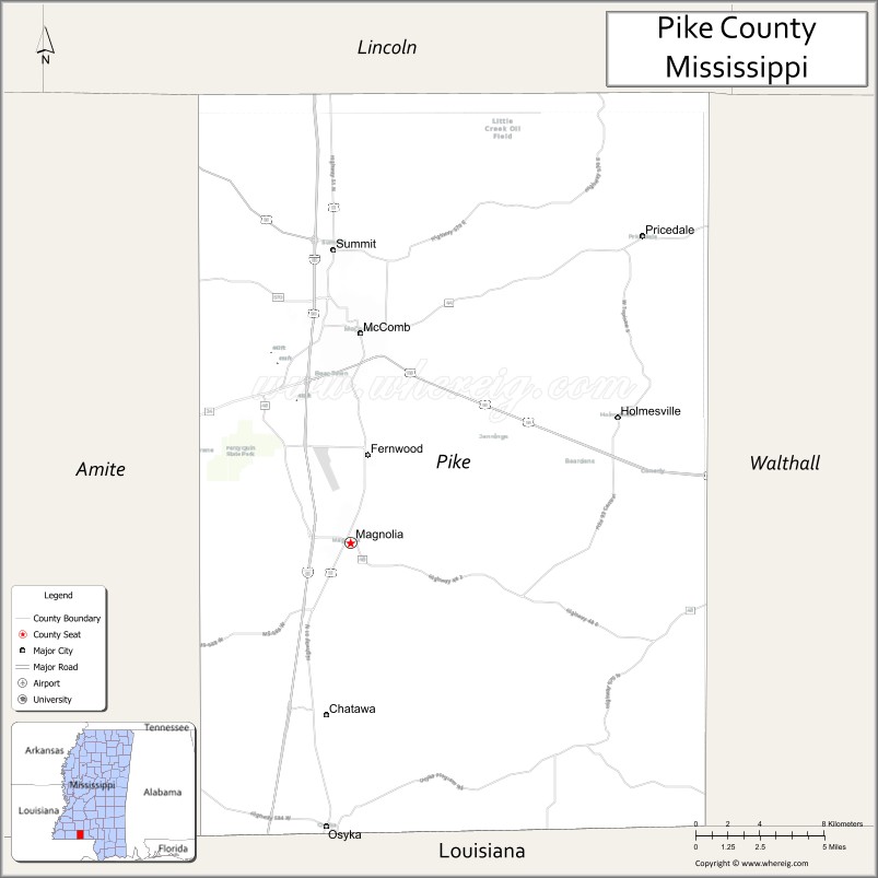
About Pike County Map, Mississippi: The map showing the county boundary, county seat, major cities, highways, water bodies and neighbouring counties.
Other Mississippi Maps & Info
Pike County, Mississippi
Pike County is a county located in the U.S. state of Mississippi. It's county seat is Magnolia. As per 2020 census, the population of Pike County is 39973 people and population density is square miles. According to the United States Census Bureau, the county has a total area of 409 sq mi (1,059 km2). Pike County was established on 1815.
Pike County Facts
| Continent | North America |
| Country | United States |
| State | Mississippi |
| County Seat | Magnolia |
| Largest City/Town | McComb |
| Established | 1815 |
| Total Area | 411 sq mi (1,064 sq km) |
| Land Area | 409 sq mi (1,059 sq km) |
| Water Area | 2 sq mi (5 sq km) |
| Population | 39,539 (Census 2020) |
| Population Density | 97 people per sq mi |
| Time Zone | Central Time Zone (CST/CDT) |
| Major Highways | Interstate 55, U.S. Route 51, U.S. Route 98, Mississippi Highway 24, Mississippi Highway 44, Mississippi Highway 48 |
| Major Rivers | Bogue Chitto River, Tangipahoa River |
| Neighboring Counties | Lincoln County, Walthall County, Amite County, Wilkinson County, St. Helena Parish (LA), Tangipahoa Parish (LA) |
| Famous For | Percy Quin State Park, railroad heritage, outdoor recreation, and Southwest Mississippi culture |
| Top Attractions | Percy Quin State Park, McComb Railroad Museum, Bogue Chitto Water Park, Edgewood Park, Downtown McComb Historic District |
| Official Website | Official Website |
About Pike County, Mississippi
Pike County is located in the southwestern part of Mississippi in the southern United States and was established in 1815. The county seat is Magnolia, while McComb is the largest city. The county features rolling pine forests, rivers, and recreational areas that make it an important outdoor destination in Southwest Mississippi.
Cities and Towns in Pike County, Mississippi
| City/Town | Population (Census 2020) | Latitude & Longitude |
|---|---|---|
| Magnolia (county seat) | 2,420 | 31.1438°N, 90.4587°W |
| McComb | 12,413 | 31.2436°N, 90.4532°W |
| Summit | 1,705 | 31.2838°N, 90.4684°W |
| Osyka | 757 | 31.0085°N, 90.4720°W |
| Fernwood | 286 | 31.2010°N, 90.4548°W |
| Gillsburg (CDP) | 766 | 31.0427°N, 90.5907°W |
| Progress (CDP) | 344 | 31.1763°N, 90.4278°W |
Golf Courses in Pike County, Mississippi
| Golf Course | Location | Latitude & Longitude |
|---|---|---|
| Percy Quin State Park Golf Course | McComb | 31.1816°N, 90.6403°W |
| Quail Hollow Golf Course | McComb | 31.1955°N, 90.4724°W |
| Fernwood Country Club | McComb | 31.2232°N, 90.4703°W |
What Are the Major Roads and Highways in Pike County, Mississippi
Major highways connect the county to nearby regions and cities.
- Interstate 55 - runs north-south through Pike County connecting Jackson and New Orleans
- U.S. Route 51 - passes through Magnolia, Summit, and McComb parallel to Interstate 55
- U.S. Route 98 - connects McComb with Hattiesburg and Natchez
- Mississippi Highway 24 - links Magnolia with Liberty and Amite County
- Mississippi Highway 44 - serves communities east of McComb
- Mississippi Highway 48 - crosses southern Pike County near the Louisiana border
What are the Neighboring Counties of Pike County
- Lincoln County (north)
- Amite County (east)
- Walthall County (east)
- Wilkinson County (west)
- Tangipahoa Parish, Louisiana (south)
- St. Helena Parish, Louisiana (southwest)
What Are the Top Attractions in Pike County, Mississippi
The county offers a mix of natural and cultural attractions.
- Percy Quin State Park - large state park with a lake, cabins, trails, camping, and golf facilities
- McComb Railroad Museum - museum showcasing railroad history and vintage train exhibits
- Bogue Chitto Water Park - outdoor recreation area popular for camping, fishing, and boating
- Downtown McComb Historic District - historic downtown area with local shops and preserved buildings
- Edgewood Park - public recreation park with sports facilities and walking areas
- Pike County Courthouse - historic courthouse building located in Magnolia
- Tangipahoa River - scenic river area known for kayaking and fishing
- Black History Gallery - cultural museum focused on African American heritage in McComb
- Magnolia Depot Plaza - historic railroad-related attraction in Magnolia
- Southwest Mississippi Community College - regional educational institution with sports and events
Distance from Pike County to Nearby Cities
The following distances are measured by road (driving).
- Magnolia to McComb (Pike County), Mississippi - 6 mi (10 km)
- Magnolia to Brookhaven (Lincoln County), Mississippi - 31 mi (50 km)
- Magnolia to Jackson (Hinds County), Mississippi - 90 mi (145 km)
- Magnolia to Hattiesburg (Forrest County), Mississippi - 79 mi (127 km)
- Magnolia to Natchez (Adams County), Mississippi - 72 mi (116 km)
- Magnolia to Liberty (Amite County), Mississippi - 27 mi (43 km)
- Magnolia to Columbia (Marion County), Mississippi - 53 mi (85 km)
- Magnolia to Hammond (Tangipahoa Parish), Louisiana - 47 mi (76 km)
- Magnolia to Baton Rouge (East Baton Rouge Parish), Louisiana - 79 mi (127 km)
- Magnolia to New Orleans (Orleans Parish), Louisiana - 111 mi (179 km)
- Magnolia to Tylertown (Walthall County), Mississippi - 28 mi (45 km)
- Magnolia to Summit (Pike County), Mississippi - 10 mi (16 km)
- Magnolia to Osyka (Pike County), Mississippi - 15 mi (24 km)
FAQs about Pike County
Pike County is located in southwestern Mississippi near the Louisiana state border.
Pike County had a population of 39,539 according to the 2020 United States Census.
Pike County is known for Percy Quin State Park, railroad heritage, and outdoor recreation areas.
The major highways in Pike County include Interstate 55, U.S. Route 51, and U.S. Route 98.
Yes, Pike County has several golf courses including Percy Quin State Park Golf Course and Fernwood Country Club.
References
- QuickFacts - U.S. Census Bureau
- United States Census Bureau
- United States Geological Survey (USGS)
- National Geodetic Survey
- Official County Website
- Adams County Map
- Alcorn County Map
- Amite County Map
- Attala County Map
- Benton County Map
- Bolivar County Map
- Calhoun County Map
- Carroll County Map
- Chickasaw County Map
- Choctaw County Map
- Claiborne County Map
- Clarke County Map
- Clay County Map
- Coahoma County Map
- Copiah County Map
- Covington County Map
- DeSoto County Map
- Forrest County Map
- Franklin County Map
- George County Map
- Greene County Map
- Grenada County Map
- Hancock County Map
- Harrison County Map
- Hinds County Map
- Holmes County Map
- Humphreys County Map
- Issaquena County Map
- Itawamba County Map
- Jackson County Map
- Jasper County Map
- Jefferson County Map
- Jefferson Davis County Map
- Jones County Map
- Kemper County Map
- Lafayette County Map
- Lamar County Map
- Lauderdale County Map
- Lawrence County Map
- Leake County Map
- Lee County Map
- Leflore County Map
- Lincoln County Map
- Lowndes County Map
- Madison County Map
- Marion County Map
- Marshall County Map
- Monroe County Map
- Montgomery County Map
- Neshoba County Map
- Newton County Map
- Noxubee County Map
- Oktibbeha County Map
- Panola County Map
- Pearl River County Map
- Perry County Map
- Pike County Map
- Pontotoc County Map
- Prentiss County Map
- Quitman County Map
- Rankin County Map
- Scott County Map
- Sharkey County Map
- Simpson County Map
- Smith County Map
- Stone County Map
- Sunflower County Map
- Tallahatchie County Map
- Tate County Map
- Tippah County Map
- Tishomingo County Map
- Tunica County Map
- Union County Map
- Walthall County Map
- Warren County Map
- Washington County Map
- Wayne County Map
- Webster County Map
- Wilkinson County Map
- Winston County Map
- Yalobusha County Map
- Yazoo County Map
- Alabama Counties
- Alaska boroughs
- Arizona Counties
- Arkansas Counties
- California County Map
- Colorado Counties
- Connecticut Counties
- Delaware Counties
- Florida County Map
- Georgia County Map
- Hawaii Counties
- Idaho Counties
- Illinois Counties
- Indiana Counties
- Iowa Counties
- Kansas Counties
- Kentucky Counties
- Louisiana Counties
- Maine Counties
- Maryland Counties
- Massachusetts Counties
- Michigan County Map
- Minnesota Counties
- Mississippi Counties
- Missouri Counties
- Montana Counties
- Nebraska Counties
- Nevada Counties
- New York Counties
- New Hampshire Counties
- New Jersey Counties
- New Mexico Counties
- North Carolina Counties
- North Dakota Counties
- Ohio County Map
- Oklahoma Counties
- Oregon Counties
- Pennsylvania Counties
- Rhode Island Counties
- South Carolina Counties
- South Dakota Counties
- Map of Tennessee
- Texas County Map
- Utah Counties
- Vermont Counties
- Virginia Counties
- Washington Counties
- West Virginia Counties
- Wisconsin Counties
- Wyoming Counties