Written and Fact-checked by Whereig Editors, Reviewed by Mukesh Kumar| Last Updated On: May 12, 2026
Map of Jefferson County - Jefferson County is a county located in the U.S. state of Mississippi. Jefferson County Map showing cities, highways, important places and water bodies. Get Where is Jefferson County located in the map, major cities in Jefferson county, population, areas, and places of interest.
Map of Jefferson County, Mississippi
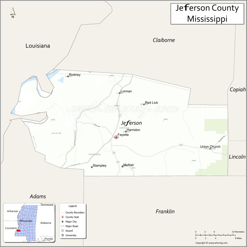
About Jefferson County Map, Mississippi: The map showing the county boundary, county seat, major cities, highways, water bodies and neighbouring counties.
Other Mississippi Maps & Info
Jefferson County, Mississippi
Jefferson County is a county located in the U.S. state of Mississippi. It's county seat is Fayette. As per 2020 census, the population of Jefferson County is 7205 people and population density is square miles. According to the United States Census Bureau, the county has a total area of 519 sq mi (1,344 km2). Jefferson County was established on 1799.
Jefferson County Facts
| Continent | North America |
| Country | United States |
| State | Mississippi |
| County Seat | Fayette |
| Largest City/Town | Fayette |
| Established | 1799 |
| Total Area | 527 sq mi (1,365 sq km) |
| Land Area | 519 sq mi (1,344 sq km) |
| Water Area | 8 sq mi (21 sq km) |
| Population | 7,260 (Census 2020) |
| Population Density | 14.0 people per sq mi |
| Time Zone | Central Time Zone |
| Major Highways | U.S. Route 61, Mississippi Highway 33, Mississippi Highway 28 |
| Major Rivers | Mississippi River nearby region, Homochitto River |
| Neighboring Counties | Claiborne County, Franklin County, Adams County, Copiah County, Lincoln County |
| Famous For | Historic plantations, Natchez Trace heritage, and rural Mississippi culture |
| Top Attractions | Historic Fayette, Windsor Ruins nearby region, and Homochitto National Forest nearby areas |
| Official Website | Official Website |
About Jefferson County, Mississippi
Jefferson County is located in southwestern Mississippi and was established in 1799, making it one of the oldest counties in the state. The county seat and largest town is Fayette. Jefferson County is known for its historic homes, plantation heritage, scenic countryside, and proximity to the Natchez Trace and Mississippi River regions.
Cities and Towns in Jefferson County, Mississippi
| City/Town | Population (Census 2020) | Latitude & Longitude |
|---|---|---|
| Fayette (county seat) | 1,372 | 31.7110°N, 91.0609°W |
| Red Lick nearby region | 1,000 | 31.7784°N, 91.1125°W |
| Church Hill nearby region | 700 | 31.8245°N, 91.2031°W |
| McNair nearby region | 500 | 31.6748°N, 90.9903°W |
Golf Courses in Jefferson County, Mississippi
| Golf Course | Location | Latitude & Longitude |
|---|---|---|
| Jefferson County Community Golf Area | Fayette | 31.7168°N, 91.0644°W |
| Southwest Mississippi Regional Golf Facilities nearby region | Nearby region | 31.7251°N, 91.0520°W |
What Are the Major Roads and Highways in Jefferson County, Mississippi
Major highways connect Jefferson County with Natchez, Jackson, and surrounding southwest Mississippi communities.
- U.S. Route 61 - historic highway connecting Mississippi River communities
- Mississippi Highway 33 - regional north-south route through forest and agricultural areas
- Mississippi Highway 28 - east-west corridor serving rural southwest Mississippi
What are the Neighboring Counties of Jefferson County
- Claiborne County (north)
- Copiah County (east)
- Lincoln County (southeast)
- Franklin County (south)
- Adams County (southwest)
What Are the Top Attractions in Jefferson County, Mississippi
The county offers historic landmarks, scenic countryside, and outdoor recreation opportunities.
- Historic Fayette - county seat featuring historic buildings, local museums, and Southern heritage sites
- Windsor Ruins Nearby Region - famous antebellum ruins and photography destination near the Mississippi River region
- Homochitto National Forest Nearby Areas - hiking, camping, hunting, and wildlife recreation opportunities
- Natchez Trace Heritage Routes - scenic drives through historic Mississippi landscapes
- Historic Plantation Sites - preserved landmarks reflecting early Mississippi history and architecture
- Homochitto River Recreation Areas - fishing, kayaking, and outdoor adventure destinations
- Scenic Southwest Mississippi Countryside - rolling hills and forest landscapes ideal for nature exploration
- Historic Churches and Cemeteries - preserved cultural and historical sites throughout the county
- Community Festivals and Heritage Events - celebrations highlighting local traditions and Southern culture
- Wildlife Observation and Hunting Areas - outdoor recreation spaces supporting native wildlife habitats
Distance from Jefferson County to Nearby Cities
The following distances are measured by road (driving).
- Fayette to Natchez, Mississippi - 34 mi (55 km)
- Fayette to Jackson, Mississippi - 79 mi (127 km)
- Fayette to Brookhaven, Mississippi - 53 mi (85 km)
- Fayette to Baton Rouge, Louisiana - 74 mi (119 km)
- Fayette to Vicksburg, Mississippi - 79 mi (127 km)
- Fayette to Hattiesburg, Mississippi - 129 mi (208 km)
- Fayette to New Orleans, Louisiana - 146 mi (235 km)
- Fayette to Shreveport, Louisiana - 225 mi (362 km)
- Fayette to Birmingham, Alabama - 275 mi (443 km)
- Fayette to Memphis, Tennessee - 266 mi (428 km)
- Fayette to Houston, Texas - 314 mi (505 km)
- Fayette to Atlanta, Georgia - 420 mi (676 km)
FAQs about Jefferson County
Jefferson County is located in southwestern Mississippi.
Jefferson County had a population of 7,260 according to Census 2020 data.
Jefferson County is known for historic plantations, Natchez Trace heritage, and rural Mississippi culture.
The county is served by U.S. Route 61, Mississippi Highway 33, and Mississippi Highway 28.
Jefferson County has local and nearby regional golf facilities serving southwest Mississippi.
References
- QuickFacts - U.S. Census Bureau
- United States Census Bureau
- Official County Website
- Homochitto National Forest
- Visit Mississippi
- Adams County Map
- Alcorn County Map
- Amite County Map
- Attala County Map
- Benton County Map
- Bolivar County Map
- Calhoun County Map
- Carroll County Map
- Chickasaw County Map
- Choctaw County Map
- Claiborne County Map
- Clarke County Map
- Clay County Map
- Coahoma County Map
- Copiah County Map
- Covington County Map
- DeSoto County Map
- Forrest County Map
- Franklin County Map
- George County Map
- Greene County Map
- Grenada County Map
- Hancock County Map
- Harrison County Map
- Hinds County Map
- Holmes County Map
- Humphreys County Map
- Issaquena County Map
- Itawamba County Map
- Jackson County Map
- Jasper County Map
- Jefferson County Map
- Jefferson Davis County Map
- Jones County Map
- Kemper County Map
- Lafayette County Map
- Lamar County Map
- Lauderdale County Map
- Lawrence County Map
- Leake County Map
- Lee County Map
- Leflore County Map
- Lincoln County Map
- Lowndes County Map
- Madison County Map
- Marion County Map
- Marshall County Map
- Monroe County Map
- Montgomery County Map
- Neshoba County Map
- Newton County Map
- Noxubee County Map
- Oktibbeha County Map
- Panola County Map
- Pearl River County Map
- Perry County Map
- Pike County Map
- Pontotoc County Map
- Prentiss County Map
- Quitman County Map
- Rankin County Map
- Scott County Map
- Sharkey County Map
- Simpson County Map
- Smith County Map
- Stone County Map
- Sunflower County Map
- Tallahatchie County Map
- Tate County Map
- Tippah County Map
- Tishomingo County Map
- Tunica County Map
- Union County Map
- Walthall County Map
- Warren County Map
- Washington County Map
- Wayne County Map
- Webster County Map
- Wilkinson County Map
- Winston County Map
- Yalobusha County Map
- Yazoo County Map
- Alabama Counties
- Alaska boroughs
- Arizona Counties
- Arkansas Counties
- California County Map
- Colorado Counties
- Connecticut Counties
- Delaware Counties
- Florida County Map
- Georgia County Map
- Hawaii Counties
- Idaho Counties
- Illinois Counties
- Indiana Counties
- Iowa Counties
- Kansas Counties
- Kentucky Counties
- Louisiana Counties
- Maine Counties
- Maryland Counties
- Massachusetts Counties
- Michigan County Map
- Minnesota Counties
- Mississippi Counties
- Missouri Counties
- Montana Counties
- Nebraska Counties
- Nevada Counties
- New York Counties
- New Hampshire Counties
- New Jersey Counties
- New Mexico Counties
- North Carolina Counties
- North Dakota Counties
- Ohio County Map
- Oklahoma Counties
- Oregon Counties
- Pennsylvania Counties
- Rhode Island Counties
- South Carolina Counties
- South Dakota Counties
- Map of Tennessee
- Texas County Map
- Utah Counties
- Vermont Counties
- Virginia Counties
- Washington Counties
- West Virginia Counties
- Wisconsin Counties
- Wyoming Counties