Written and Fact-checked by Whereig Editors, Reviewed by Mukesh Kumar| Last Updated On: May 12, 2026
Map of Forrest County - Forrest County is a county located in the U.S. state of Mississippi. Forrest County Map showing cities, highways, important places and water bodies. Get Where is Forrest County located in the map, major cities in Forrest county, population, areas, and places of interest.
Map of Forrest County, Mississippi
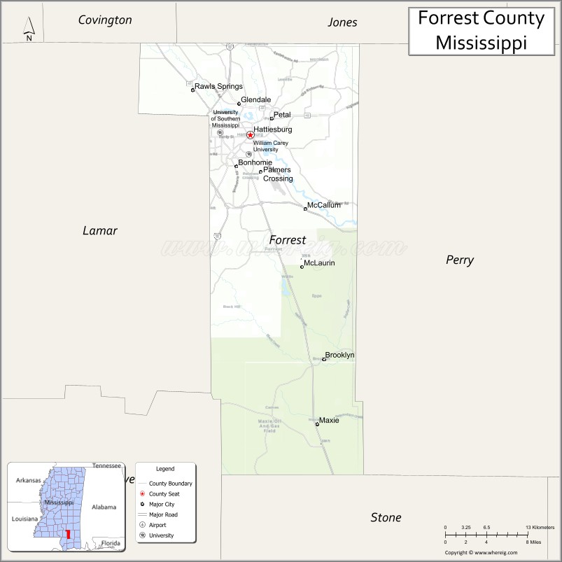
About Forrest County Map, Mississippi: The map showing the county boundary, county seat, major cities, highways, water bodies and neighbouring counties.
Other Mississippi Maps & Info
Forrest County, Mississippi
Forrest County is a county located in the U.S. state of Mississippi. It's county seat is Hattiesburg. As per 2020 census, the population of Forrest County is 77875 people and population density is square miles. According to the United States Census Bureau, the county has a total area of 467 sq mi (1,210 km2). Forrest County was established on 1906.
Forrest County Facts
| Continent | North America |
| Country | United States |
| State | Mississippi |
| County Seat | Hattiesburg |
| Largest City/Town | Hattiesburg |
| Established | 1906 |
| Total Area | 470 sq mi (1,217 sq km) |
| Land Area | 466 sq mi (1,207 sq km) |
| Water Area | 4 sq mi (10 sq km) |
| Population | 74,170 (Census 2020) |
| Population Density | 159.2 people per sq mi |
| Time Zone | Central Time Zone |
| Major Highways | Interstate 59, U.S. Route 49, U.S. Route 98 |
| Major Rivers | Leaf River, Bouie River |
| Neighboring Counties | Lamar County, Perry County, Jones County, Covington County, Greene County |
| Famous For | University culture, Hattiesburg, and Southern Mississippi arts and music |
| Top Attractions | University of Southern Mississippi, Hattiesburg Zoo, and Longleaf Trace |
| Official Website | Official Website |
About Forrest County, Mississippi
Forrest County is located in southeastern Mississippi and was established in 1906. The county seat and largest city is Hattiesburg, a major educational and cultural center in southern Mississippi. The county is known for higher education, healthcare, arts, music, and outdoor recreation opportunities.
Cities and Towns in Forrest County, Mississippi
| City/Town | Population (Census 2020) | Latitude & Longitude |
|---|---|---|
| Hattiesburg (county seat) | 45,989 | 31.3271°N, 89.2903°W |
| Petal | 10,147 | 31.3466°N, 89.2601°W |
| Rawls Springs | 5,000 | 31.2324°N, 89.3787°W |
| Sunrise nearby region | 1,200 | 31.3572°N, 89.3284°W |
Golf Courses in Forrest County, Mississippi
| Golf Course | Location | Latitude & Longitude |
|---|---|---|
| Canebrake Country Club | Hattiesburg | 31.3138°N, 89.3781°W |
| Hattiesburg Country Club | Hattiesburg | 31.3215°N, 89.3124°W |
| Pine Creek Golf Club | Purvis nearby region | 31.1467°N, 89.4135°W |
What Are the Major Roads and Highways in Forrest County, Mississippi
Major highways make Forrest County an important transportation center in southern Mississippi.
- Interstate 59 - major interstate highway connecting New Orleans and Birmingham
- U.S. Route 49 - important north-south corridor linking the Gulf Coast with Jackson
- U.S. Route 98 - east-west highway connecting Mississippi with Alabama and Louisiana
What are the Neighboring Counties of Forrest County
- Jones County (north)
- Perry County (east)
- Greene County (southeast)
- Lamar County (southwest)
- Covington County (west)
What Are the Top Attractions in Forrest County, Mississippi
The county offers a mix of educational attractions, outdoor recreation, arts, and entertainment.
- University of Southern Mississippi - major public university known for academics, athletics, and cultural events
- Hattiesburg Zoo - family-friendly attraction featuring animals, exhibits, and educational programs
- Longleaf Trace - scenic multi-use trail popular for biking, walking, and outdoor recreation
- Historic Downtown Hattiesburg - arts district with murals, restaurants, galleries, and local shops
- African American Military History Museum - exhibits honoring African American military service and local history
- Pep's Point Water Park - seasonal recreation destination with swimming and family activities
- Lake Thoreau Environmental Center - nature trails and environmental education programs
- Leaf River Recreation Areas - kayaking, fishing, canoeing, and wildlife observation opportunities
- Hattiesburg Pocket Museum - unique public art installation and creative downtown attraction
- Annual Festivals and Live Music Events - celebrations showcasing Southern Mississippi culture and entertainment
Distance from Forrest County to Nearby Cities
The following distances are measured by road (driving).
- Hattiesburg to Gulfport, Mississippi - 72 mi (116 km)
- Hattiesburg to Biloxi, Mississippi - 78 mi (126 km)
- Hattiesburg to Jackson, Mississippi - 90 mi (145 km)
- Hattiesburg to Mobile, Alabama - 90 mi (145 km)
- Hattiesburg to New Orleans, Louisiana - 112 mi (180 km)
- Hattiesburg to Baton Rouge, Louisiana - 147 mi (237 km)
- Hattiesburg to Meridian, Mississippi - 91 mi (146 km)
- Hattiesburg to Birmingham, Alabama - 214 mi (344 km)
- Hattiesburg to Memphis, Tennessee - 301 mi (484 km)
- Hattiesburg to Atlanta, Georgia - 337 mi (542 km)
- Hattiesburg to Houston, Texas - 390 mi (628 km)
- Hattiesburg to Dallas, Texas - 505 mi (813 km)
FAQs about Forrest County
Forrest County is located in southeastern Mississippi.
Forrest County had a population of 74,170 according to Census 2020 data.
Forrest County is known for university culture, Hattiesburg, and Southern Mississippi arts and music.
The county is served by Interstate 59, U.S. Route 49, and U.S. Route 98.
Yes, Forrest County has golf facilities including Canebrake Country Club, Hattiesburg Country Club, and Pine Creek Golf Club.
References
- QuickFacts - U.S. Census Bureau
- United States Census Bureau
- The University of Southern Mississippi
- Hattiesburg Zoo
- Official County Website
- Adams County Map
- Alcorn County Map
- Amite County Map
- Attala County Map
- Benton County Map
- Bolivar County Map
- Calhoun County Map
- Carroll County Map
- Chickasaw County Map
- Choctaw County Map
- Claiborne County Map
- Clarke County Map
- Clay County Map
- Coahoma County Map
- Copiah County Map
- Covington County Map
- DeSoto County Map
- Forrest County Map
- Franklin County Map
- George County Map
- Greene County Map
- Grenada County Map
- Hancock County Map
- Harrison County Map
- Hinds County Map
- Holmes County Map
- Humphreys County Map
- Issaquena County Map
- Itawamba County Map
- Jackson County Map
- Jasper County Map
- Jefferson County Map
- Jefferson Davis County Map
- Jones County Map
- Kemper County Map
- Lafayette County Map
- Lamar County Map
- Lauderdale County Map
- Lawrence County Map
- Leake County Map
- Lee County Map
- Leflore County Map
- Lincoln County Map
- Lowndes County Map
- Madison County Map
- Marion County Map
- Marshall County Map
- Monroe County Map
- Montgomery County Map
- Neshoba County Map
- Newton County Map
- Noxubee County Map
- Oktibbeha County Map
- Panola County Map
- Pearl River County Map
- Perry County Map
- Pike County Map
- Pontotoc County Map
- Prentiss County Map
- Quitman County Map
- Rankin County Map
- Scott County Map
- Sharkey County Map
- Simpson County Map
- Smith County Map
- Stone County Map
- Sunflower County Map
- Tallahatchie County Map
- Tate County Map
- Tippah County Map
- Tishomingo County Map
- Tunica County Map
- Union County Map
- Walthall County Map
- Warren County Map
- Washington County Map
- Wayne County Map
- Webster County Map
- Wilkinson County Map
- Winston County Map
- Yalobusha County Map
- Yazoo County Map
- Alabama Counties
- Alaska boroughs
- Arizona Counties
- Arkansas Counties
- California County Map
- Colorado Counties
- Connecticut Counties
- Delaware Counties
- Florida County Map
- Georgia County Map
- Hawaii Counties
- Idaho Counties
- Illinois Counties
- Indiana Counties
- Iowa Counties
- Kansas Counties
- Kentucky Counties
- Louisiana Counties
- Maine Counties
- Maryland Counties
- Massachusetts Counties
- Michigan County Map
- Minnesota Counties
- Mississippi Counties
- Missouri Counties
- Montana Counties
- Nebraska Counties
- Nevada Counties
- New York Counties
- New Hampshire Counties
- New Jersey Counties
- New Mexico Counties
- North Carolina Counties
- North Dakota Counties
- Ohio County Map
- Oklahoma Counties
- Oregon Counties
- Pennsylvania Counties
- Rhode Island Counties
- South Carolina Counties
- South Dakota Counties
- Map of Tennessee
- Texas County Map
- Utah Counties
- Vermont Counties
- Virginia Counties
- Washington Counties
- West Virginia Counties
- Wisconsin Counties
- Wyoming Counties