Written and Fact-checked by Whereig Editors, Reviewed by Mukesh Kumar| Last Updated On: May 12, 2026
Map of Copiah County - Copiah County is a county located in the U.S. state of Mississippi. Copiah County Map showing cities, highways, important places and water bodies. Get Where is Copiah County located in the map, major cities in Copiah county, population, areas, and places of interest.
Map of Copiah County, Mississippi
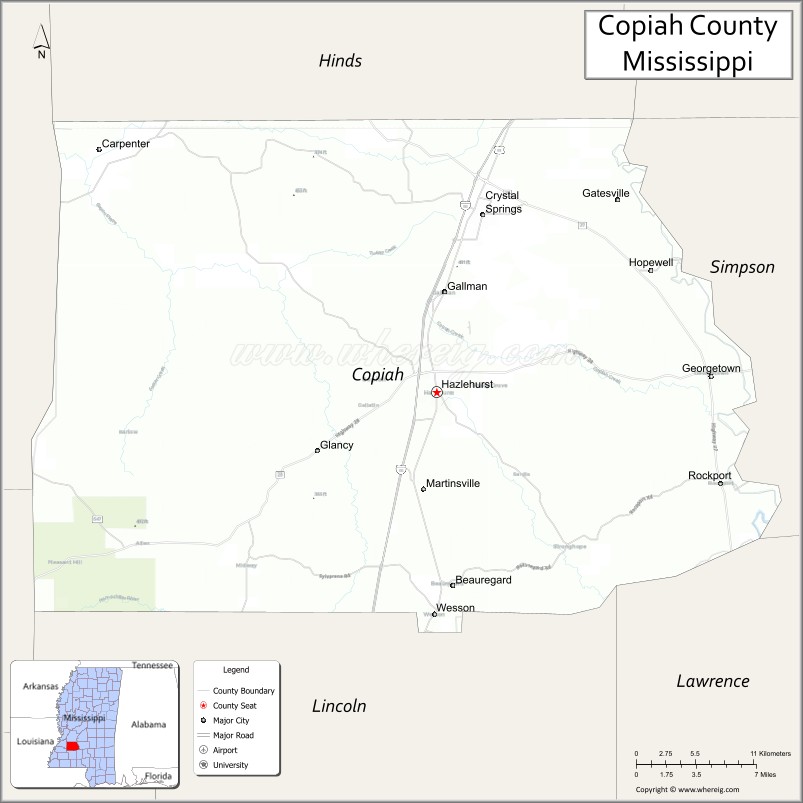
About Copiah County Map, Mississippi: The map showing the county boundary, county seat, major cities, highways, water bodies and neighbouring counties.
Other Mississippi Maps & Info
Copiah County, Mississippi
Copiah County is a county located in the U.S. state of Mississippi. It's county seat is Hazlehurst. As per 2020 census, the population of Copiah County is 27995 people and population density is square miles. According to the United States Census Bureau, the county has a total area of 777 sq mi (2,012 km2). Copiah County was established on 1823.
Copiah County Facts
| Continent | North America |
| Country | United States |
| State | Mississippi |
| County Seat | Hazlehurst |
| Largest City/Town | Hazlehurst |
| Established | 1823 |
| Total Area | 780 sq mi (2,020 sq km) |
| Land Area | 777 sq mi (2,012 sq km) |
| Water Area | 3 sq mi (7.8 sq km) |
| Population | 28,862 (Census 2020) |
| Population Density | 37.1 people per sq mi |
| Time Zone | Central Time Zone |
| Major Highways | Interstate 55, U.S. Route 51, Mississippi Highway 27 |
| Major Rivers | Pearl River, Copiah Creek |
| Neighboring Counties | Hinds County, Simpson County, Lawrence County, Lincoln County, Claiborne County, Jefferson County |
| Famous For | Historic towns, agriculture, and scenic Central Mississippi landscapes |
| Top Attractions | Lake Copiah, Wesson Campus area, and Hazlehurst Historic District |
| Official Website | Official Website |
About Copiah County, Mississippi
Copiah County is located in central Mississippi and was established in 1823. The county seat and largest city is Hazlehurst. The county is known for its agricultural heritage, historic railroad communities, scenic countryside, and educational institutions including the Copiah-Lincoln Community College campus in Wesson.
Cities and Towns in Copiah County, Mississippi
| City/Town | Population (Census 2020) | Latitude & Longitude |
|---|---|---|
| Hazlehurst (county seat) | 3,543 | 31.8604°N, 90.3956°W |
| Crystal Springs | 4,746 | 31.9871°N, 90.3570°W |
| Wesson | 1,279 | 31.7010°N, 90.3970°W |
| Georgetown | 286 | 31.8724°N, 90.1665°W |
| Gallman nearby region | 800 | 31.9460°N, 90.4357°W |
Golf Courses in Copiah County, Mississippi
| Golf Course | Location | Latitude & Longitude |
|---|---|---|
| Wolf Hollow Golf Club | Wesson | 31.7084°N, 90.4039°W |
| Crystal Springs Golf Facilities | Crystal Springs | 31.9923°N, 90.3611°W |
What Are the Major Roads and Highways in Copiah County, Mississippi
Major highways connect Copiah County with Jackson, southern Mississippi, and regional transportation corridors.
- Interstate 55 - major north-south interstate highway through central Mississippi
- U.S. Route 51 - historic route paralleling Interstate 55 through county communities
- Mississippi Highway 27 - regional highway connecting rural towns and recreation areas
What are the Neighboring Counties of Copiah County
- Hinds County (north)
- Simpson County (east)
- Lawrence County (southeast)
- Lincoln County (south)
- Jefferson County (southwest)
- Claiborne County (west)
What Are the Top Attractions in Copiah County, Mississippi
The county offers a mix of outdoor recreation, historical attractions, and Southern cultural heritage.
- Lake Copiah - popular recreation destination for fishing, boating, and camping
- Wesson Campus Area - home to Copiah-Lincoln Community College and scenic educational grounds
- Hazlehurst Historic District - preserved downtown area with historic buildings and local shops
- Crystal Springs Tomato Festival - annual celebration honoring the area’s agricultural traditions
- Wolf Hollow Golf Club - scenic golf course and recreation facility near Wesson
- Pearl River Recreation Areas - outdoor spaces ideal for fishing, kayaking, and wildlife observation
- Scenic Central Mississippi Drives - countryside routes featuring forests and farmland
- Historic Churches and Community Landmarks - preserved sites reflecting regional heritage
- Community Parks and Outdoor Recreation Areas - family-friendly spaces for sports and relaxation
- Annual County Festivals and Heritage Events - celebrations showcasing local culture and traditions
Distance from Copiah County to Nearby Cities
The following distances are measured by road (driving).
- Hazlehurst to Jackson, Mississippi - 39 mi (63 km)
- Hazlehurst to Brookhaven, Mississippi - 28 mi (45 km)
- Hazlehurst to Natchez, Mississippi - 74 mi (119 km)
- Hazlehurst to Hattiesburg, Mississippi - 82 mi (132 km)
- Hazlehurst to Vicksburg, Mississippi - 63 mi (101 km)
- Hazlehurst to Baton Rouge, Louisiana - 112 mi (180 km)
- Hazlehurst to Gulfport, Mississippi - 149 mi (240 km)
- Hazlehurst to New Orleans, Louisiana - 181 mi (291 km)
- Hazlehurst to Mobile, Alabama - 199 mi (320 km)
- Hazlehurst to Birmingham, Alabama - 247 mi (398 km)
- Hazlehurst to Memphis, Tennessee - 246 mi (396 km)
- Hazlehurst to Houston, Texas - 376 mi (605 km)
FAQs about Copiah County
Copiah County is located in central Mississippi.
Copiah County had a population of 28,862 according to Census 2020 data.
Copiah County is known for historic towns, agriculture, and scenic Central Mississippi landscapes.
The county is served by Interstate 55, U.S. Route 51, and Mississippi Highway 27.
Yes, Copiah County has golf facilities including Wolf Hollow Golf Club and recreation courses near Crystal Springs.
References
- QuickFacts - U.S. Census Bureau
- United States Census Bureau
- Visit Mississippi
- Copiah-Lincoln Community College
- Official County Website
- Adams County Map
- Alcorn County Map
- Amite County Map
- Attala County Map
- Benton County Map
- Bolivar County Map
- Calhoun County Map
- Carroll County Map
- Chickasaw County Map
- Choctaw County Map
- Claiborne County Map
- Clarke County Map
- Clay County Map
- Coahoma County Map
- Copiah County Map
- Covington County Map
- DeSoto County Map
- Forrest County Map
- Franklin County Map
- George County Map
- Greene County Map
- Grenada County Map
- Hancock County Map
- Harrison County Map
- Hinds County Map
- Holmes County Map
- Humphreys County Map
- Issaquena County Map
- Itawamba County Map
- Jackson County Map
- Jasper County Map
- Jefferson County Map
- Jefferson Davis County Map
- Jones County Map
- Kemper County Map
- Lafayette County Map
- Lamar County Map
- Lauderdale County Map
- Lawrence County Map
- Leake County Map
- Lee County Map
- Leflore County Map
- Lincoln County Map
- Lowndes County Map
- Madison County Map
- Marion County Map
- Marshall County Map
- Monroe County Map
- Montgomery County Map
- Neshoba County Map
- Newton County Map
- Noxubee County Map
- Oktibbeha County Map
- Panola County Map
- Pearl River County Map
- Perry County Map
- Pike County Map
- Pontotoc County Map
- Prentiss County Map
- Quitman County Map
- Rankin County Map
- Scott County Map
- Sharkey County Map
- Simpson County Map
- Smith County Map
- Stone County Map
- Sunflower County Map
- Tallahatchie County Map
- Tate County Map
- Tippah County Map
- Tishomingo County Map
- Tunica County Map
- Union County Map
- Walthall County Map
- Warren County Map
- Washington County Map
- Wayne County Map
- Webster County Map
- Wilkinson County Map
- Winston County Map
- Yalobusha County Map
- Yazoo County Map
- Alabama Counties
- Alaska boroughs
- Arizona Counties
- Arkansas Counties
- California County Map
- Colorado Counties
- Connecticut Counties
- Delaware Counties
- Florida County Map
- Georgia County Map
- Hawaii Counties
- Idaho Counties
- Illinois Counties
- Indiana Counties
- Iowa Counties
- Kansas Counties
- Kentucky Counties
- Louisiana Counties
- Maine Counties
- Maryland Counties
- Massachusetts Counties
- Michigan County Map
- Minnesota Counties
- Mississippi Counties
- Missouri Counties
- Montana Counties
- Nebraska Counties
- Nevada Counties
- New York Counties
- New Hampshire Counties
- New Jersey Counties
- New Mexico Counties
- North Carolina Counties
- North Dakota Counties
- Ohio County Map
- Oklahoma Counties
- Oregon Counties
- Pennsylvania Counties
- Rhode Island Counties
- South Carolina Counties
- South Dakota Counties
- Map of Tennessee
- Texas County Map
- Utah Counties
- Vermont Counties
- Virginia Counties
- Washington Counties
- West Virginia Counties
- Wisconsin Counties
- Wyoming Counties