Written and Fact-checked by Whereig Editors, Reviewed by Mukesh Kumar| Last Updated On: May 12, 2026
Map of Jackson County - Jackson County is a county located in the U.S. state of Mississippi. Jackson County Map showing cities, highways, important places and water bodies. Get Where is Jackson County located in the map, major cities in Jackson county, population, areas, and places of interest.
Map of Jackson County, Mississippi
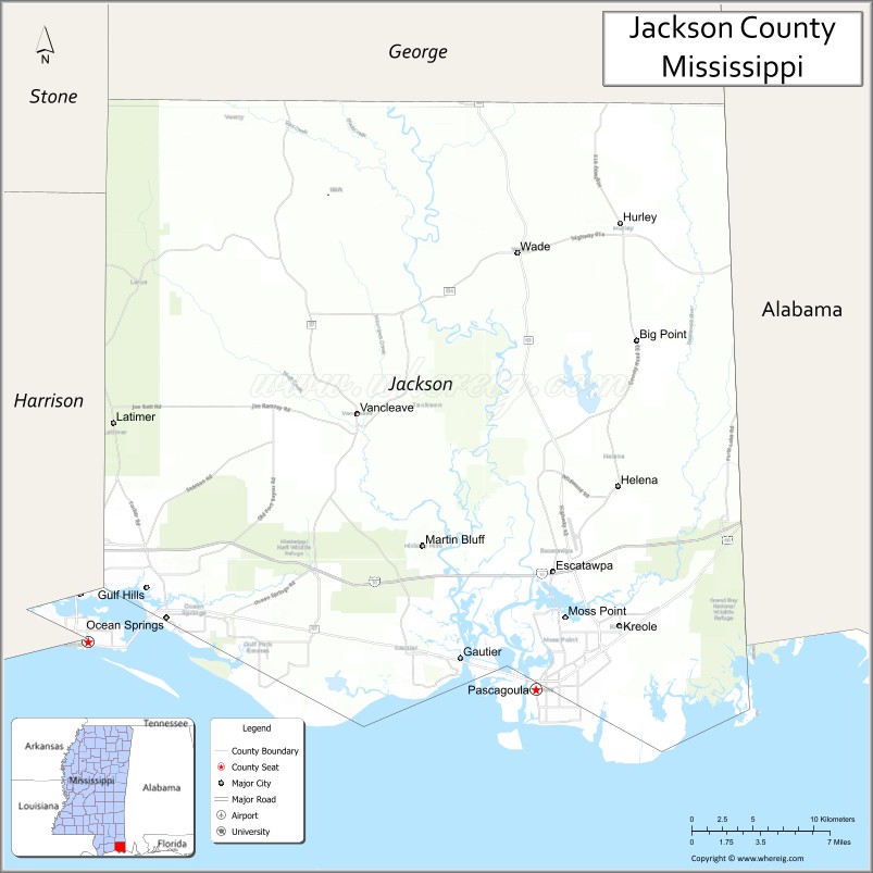
About Jackson County Map, Mississippi: The map showing the county boundary, county seat, major cities, highways, water bodies and neighbouring counties.
Other Mississippi Maps & Info
Jackson County, Mississippi
Jackson County is a county located in the U.S. state of Mississippi. It's county seat is Pascagoula. As per 2020 census, the population of Jackson County is 143987 people and population density is square miles. According to the United States Census Bureau, the county has a total area of 727 sq mi (1,883 km2). Jackson County was established on 1812.
Jackson County Facts
| Continent | North America |
| Country | United States |
| State | Mississippi |
| County Seat | Pascagoula |
| Largest City/Town | Pascagoula |
| Established | 1812 |
| Total Area | 1,043 sq mi (2,701 sq km) |
| Land Area | 723 sq mi (1,873 sq km) |
| Water Area | 320 sq mi (829 sq km) |
| Population | 143,252 (Census 2020) |
| Population Density | 198.1 people per sq mi |
| Time Zone | Central Time Zone |
| Major Highways | Interstate 10, U.S. Route 90, Mississippi Highway 57 |
| Major Rivers | Pascagoula River, Escatawpa River |
| Neighboring Counties | Harrison County, George County, Stone County, Mobile County (Alabama) |
| Famous For | Shipbuilding, Gulf Coast beaches, Pascagoula River ecology, and seafood industries |
| Top Attractions | Pascagoula Beach Park, Gulf Islands National Seashore nearby region, and Mississippi Sandhill Crane National Wildlife Refuge |
| Official Website | Official Website |
About Jackson County, Mississippi
Jackson County is located on the Mississippi Gulf Coast bordering Alabama and was established in 1812. The county seat and largest city is Pascagoula, an important shipbuilding and industrial center. Jackson County is known for coastal recreation, seafood industries, wildlife refuges, and the Pascagoula River system, one of the largest free-flowing river systems in the United States.
Cities and Towns in Jackson County, Mississippi
| City/Town | Population (Census 2020) | Latitude & Longitude |
|---|---|---|
| Pascagoula (county seat) | 21,676 | 30.3658°N, 88.5561°W |
| Ocean Springs | 18,997 | 30.4113°N, 88.8278°W |
| Moss Point | 13,704 | 30.4113°N, 88.5345°W |
| Gautier | 18,572 | 30.3858°N, 88.6117°W |
| Hurley nearby region | 1,600 | 30.6360°N, 88.4967°W |
| Vancleave nearby region | 5,500 | 30.5407°N, 88.6895°W |
Golf Courses in Jackson County, Mississippi
| Golf Course | Location | Latitude & Longitude |
|---|---|---|
| Shell Landing Golf Club | Gautier | 30.4116°N, 88.6668°W |
| The Preserve Golf Club | Vancleave | 30.5320°N, 88.8374°W |
| Hickory Hill Country Club | Gautier | 30.3796°N, 88.6461°W |
What Are the Major Roads and Highways in Jackson County, Mississippi
Major highways connect Jackson County with Gulf Coast cities and southeastern Alabama.
- Interstate 10 - major interstate corridor linking Gulf Coast metropolitan areas
- U.S. Route 90 - scenic coastal highway serving Mississippi Gulf Coast communities
- Mississippi Highway 57 - regional north-south route connecting inland and coastal regions
What are the Neighboring Counties of Jackson County
- Harrison County (west)
- Stone County (northwest)
- George County (north)
- Mobile County, Alabama (east)
What Are the Top Attractions in Jackson County, Mississippi
The county offers coastal recreation, wildlife refuges, museums, and Gulf Coast entertainment.
- Pascagoula Beach Park - Gulf Coast waterfront recreation area with beaches and fishing access
- Mississippi Sandhill Crane National Wildlife Refuge - protected habitat featuring trails and endangered wildlife
- Gulf Islands National Seashore Nearby Region - scenic barrier island beaches and historic coastal landscapes
- Ocean Springs Historic District - arts and cultural area with galleries, restaurants, and boutiques
- Pascagoula River Audubon Center - environmental education and eco-tourism destination
- Walter Anderson Museum of Art - museum celebrating Gulf Coast art and regional culture
- Shepard State Park - outdoor recreation area with camping, hiking, and fishing opportunities
- Moss Point Riverfront Areas - boating, kayaking, and waterfront activities
- Shipbuilding Heritage Sites - attractions connected to the county’s maritime and industrial history
- Annual Gulf Coast Festivals and Seafood Events - celebrations featuring local cuisine, music, and culture
Distance from Jackson County to Nearby Cities
The following distances are measured by road (driving).
- Pascagoula to Biloxi, Mississippi - 36 mi (58 km)
- Pascagoula to Gulfport, Mississippi - 51 mi (82 km)
- Pascagoula to Mobile, Alabama - 42 mi (68 km)
- Pascagoula to New Orleans, Louisiana - 111 mi (179 km)
- Pascagoula to Hattiesburg, Mississippi - 90 mi (145 km)
- Pascagoula to Baton Rouge, Louisiana - 179 mi (288 km)
- Pascagoula to Montgomery, Alabama - 184 mi (296 km)
- Pascagoula to Jackson, Mississippi - 179 mi (288 km)
- Pascagoula to Birmingham, Alabama - 254 mi (409 km)
- Pascagoula to Atlanta, Georgia - 346 mi (557 km)
- Pascagoula to Houston, Texas - 413 mi (665 km)
- Pascagoula to Dallas, Texas - 572 mi (920 km)
FAQs about Jackson County
Jackson County is located on the Mississippi Gulf Coast bordering Alabama.
Jackson County had a population of 143,252 according to Census 2020 data.
Jackson County is known for shipbuilding, Gulf Coast beaches, Pascagoula River ecology, and seafood industries.
The county is served by Interstate 10, U.S. Route 90, and Mississippi Highway 57.
Yes, Jackson County has golf facilities including Shell Landing Golf Club, The Preserve Golf Club, and Hickory Hill Country Club.
References
- QuickFacts - U.S. Census Bureau
- United States Census Bureau
- Official County Website
- Visit Mississippi Gulf Coast
- Mississippi Sandhill Crane National Wildlife Refuge
- Adams County Map
- Alcorn County Map
- Amite County Map
- Attala County Map
- Benton County Map
- Bolivar County Map
- Calhoun County Map
- Carroll County Map
- Chickasaw County Map
- Choctaw County Map
- Claiborne County Map
- Clarke County Map
- Clay County Map
- Coahoma County Map
- Copiah County Map
- Covington County Map
- DeSoto County Map
- Forrest County Map
- Franklin County Map
- George County Map
- Greene County Map
- Grenada County Map
- Hancock County Map
- Harrison County Map
- Hinds County Map
- Holmes County Map
- Humphreys County Map
- Issaquena County Map
- Itawamba County Map
- Jackson County Map
- Jasper County Map
- Jefferson County Map
- Jefferson Davis County Map
- Jones County Map
- Kemper County Map
- Lafayette County Map
- Lamar County Map
- Lauderdale County Map
- Lawrence County Map
- Leake County Map
- Lee County Map
- Leflore County Map
- Lincoln County Map
- Lowndes County Map
- Madison County Map
- Marion County Map
- Marshall County Map
- Monroe County Map
- Montgomery County Map
- Neshoba County Map
- Newton County Map
- Noxubee County Map
- Oktibbeha County Map
- Panola County Map
- Pearl River County Map
- Perry County Map
- Pike County Map
- Pontotoc County Map
- Prentiss County Map
- Quitman County Map
- Rankin County Map
- Scott County Map
- Sharkey County Map
- Simpson County Map
- Smith County Map
- Stone County Map
- Sunflower County Map
- Tallahatchie County Map
- Tate County Map
- Tippah County Map
- Tishomingo County Map
- Tunica County Map
- Union County Map
- Walthall County Map
- Warren County Map
- Washington County Map
- Wayne County Map
- Webster County Map
- Wilkinson County Map
- Winston County Map
- Yalobusha County Map
- Yazoo County Map
- Alabama Counties
- Alaska boroughs
- Arizona Counties
- Arkansas Counties
- California County Map
- Colorado Counties
- Connecticut Counties
- Delaware Counties
- Florida County Map
- Georgia County Map
- Hawaii Counties
- Idaho Counties
- Illinois Counties
- Indiana Counties
- Iowa Counties
- Kansas Counties
- Kentucky Counties
- Louisiana Counties
- Maine Counties
- Maryland Counties
- Massachusetts Counties
- Michigan County Map
- Minnesota Counties
- Mississippi Counties
- Missouri Counties
- Montana Counties
- Nebraska Counties
- Nevada Counties
- New York Counties
- New Hampshire Counties
- New Jersey Counties
- New Mexico Counties
- North Carolina Counties
- North Dakota Counties
- Ohio County Map
- Oklahoma Counties
- Oregon Counties
- Pennsylvania Counties
- Rhode Island Counties
- South Carolina Counties
- South Dakota Counties
- Map of Tennessee
- Texas County Map
- Utah Counties
- Vermont Counties
- Virginia Counties
- Washington Counties
- West Virginia Counties
- Wisconsin Counties
- Wyoming Counties