Written and Fact-checked by Whereig Editors, Reviewed by Mukesh Kumar| Last Updated On: May 12, 2026
Map of Itawamba County - Itawamba County is a county located in the U.S. state of Mississippi. Itawamba County Map showing cities, highways, important places and water bodies. Get Where is Itawamba County located in the map, major cities in Itawamba county, population, areas, and places of interest.
Map of Itawamba County, Mississippi
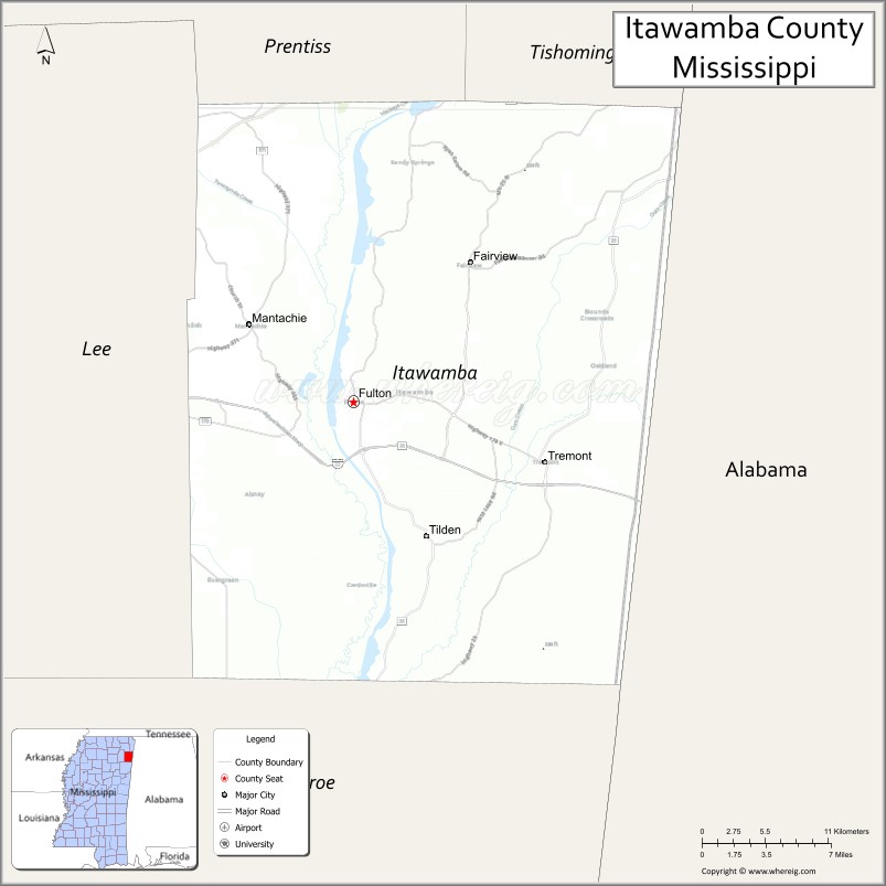
About Itawamba County Map, Mississippi: The map showing the county boundary, county seat, major cities, highways, water bodies and neighbouring counties.
Other Mississippi Maps & Info
Itawamba County, Mississippi
Itawamba County is a county located in the U.S. state of Mississippi. It's county seat is Fulton. As per 2020 census, the population of Itawamba County is 23838 people and population density is square miles. According to the United States Census Bureau, the county has a total area of 532 sq mi (1,378 km2). Itawamba County was established on 1836.
Itawamba County Facts
| Continent | North America |
| Country | United States |
| State | Mississippi |
| County Seat | Fulton |
| Largest City/Town | Fulton |
| Established | 1836 |
| Total Area | 541 sq mi (1,401 sq km) |
| Land Area | 532 sq mi (1,378 sq km) |
| Water Area | 9 sq mi (23 sq km) |
| Population | 23,863 (Census 2020) |
| Population Density | 44.9 people per sq mi |
| Time Zone | Central Time Zone |
| Major Highways | U.S. Route 78, Mississippi Highway 25, Mississippi Highway 178 |
| Major Rivers | Tennessee-Tombigbee Waterway, Tombigbee River |
| Neighboring Counties | Lee County, Monroe County, Tishomingo County, Franklin County (Alabama), Marion County (Alabama) |
| Famous For | Tennessee-Tombigbee Waterway, outdoor recreation, and Appalachian foothill scenery |
| Top Attractions | Jamie L. Whitten Historical Center, Tenn-Tom Waterway, and Fulton Historic District |
| Official Website | Official Website |
About Itawamba County, Mississippi
Itawamba County is located in northeastern Mississippi along the Alabama border and was established in 1836. The county seat and largest city is Fulton. The county is known for the Tennessee-Tombigbee Waterway, scenic rolling hills, outdoor recreation, and strong educational and agricultural traditions.
Cities and Towns in Itawamba County, Mississippi
| City/Town | Population (Census 2020) | Latitude & Longitude |
|---|---|---|
| Fulton (county seat) | 4,542 | 34.2737°N, 88.4092°W |
| Tremont | 390 | 34.2323°N, 88.2539°W |
| Mantachie | 1,132 | 34.3245°N, 88.4917°W |
| Fairview nearby region | 850 | 34.3298°N, 88.3784°W |
| Dorsey nearby region | 700 | 34.1712°N, 88.3087°W |
Golf Courses in Itawamba County, Mississippi
| Golf Course | Location | Latitude & Longitude |
|---|---|---|
| Fulton Country Club | Fulton | 34.2817°N, 88.4114°W |
| River Birch Golf Club nearby region | Northeast Mississippi region | 34.2679°N, 88.3956°W |
What Are the Major Roads and Highways in Itawamba County, Mississippi
Major highways connect Itawamba County with northeastern Mississippi and neighboring Alabama communities.
- U.S. Route 78 - major east-west transportation corridor through northeastern Mississippi
- Mississippi Highway 25 - important regional highway linking Fulton with Tupelo and Starkville
- Mississippi Highway 178 - scenic local route serving rural communities and recreation areas
What are the Neighboring Counties of Itawamba County
- Tishomingo County (north)
- Lee County (west)
- Monroe County (south)
- Franklin County, Alabama (east)
- Marion County, Alabama (southeast)
What Are the Top Attractions in Itawamba County, Mississippi
The county offers scenic waterways, outdoor recreation, and historical attractions.
- Tennessee-Tombigbee Waterway - major navigation and recreation waterway popular for boating and fishing
- Jamie L. Whitten Historical Center - museum honoring the longtime Mississippi congressman and regional history
- Fulton Historic District - downtown area featuring local shops, restaurants, and historic architecture
- Tenn-Tom Waterway Recreation Areas - camping, kayaking, boating, and scenic picnic areas
- Itawamba Community College Campus - educational institution known for athletics and regional programs
- Scenic Appalachian Foothill Drives - countryside routes showcasing rolling hills and forest landscapes
- Tombigbee River Wildlife Areas - opportunities for birdwatching, fishing, and photography
- Community Parks and Recreation Facilities - sports fields, walking trails, and family recreation spaces
- Historic Churches and Heritage Sites - preserved landmarks reflecting local Southern culture
- Outdoor Hunting and Fishing Areas - popular recreation destinations throughout northeastern Mississippi
Distance from Itawamba County to Nearby Cities
The following distances are measured by road (driving).
- Fulton to Tupelo, Mississippi - 27 mi (43 km)
- Fulton to Columbus, Mississippi - 71 mi (114 km)
- Fulton to Oxford, Mississippi - 77 mi (124 km)
- Fulton to Birmingham, Alabama - 123 mi (198 km)
- Fulton to Memphis, Tennessee - 125 mi (201 km)
- Fulton to Huntsville, Alabama - 103 mi (166 km)
- Fulton to Jackson, Mississippi - 186 mi (299 km)
- Fulton to Nashville, Tennessee - 209 mi (336 km)
- Fulton to Atlanta, Georgia - 249 mi (401 km)
- Fulton to New Orleans, Louisiana - 356 mi (573 km)
- Fulton to Dallas, Texas - 458 mi (737 km)
- Fulton to Houston, Texas - 507 mi (816 km)
FAQs about Itawamba County
Itawamba County is located in northeastern Mississippi along the Alabama border.
Itawamba County had a population of 23,863 according to Census 2020 data.
Itawamba County is known for the Tennessee-Tombigbee Waterway, outdoor recreation, and Appalachian foothill scenery.
The county is served by U.S. Route 78, Mississippi Highway 25, and Mississippi Highway 178.
Yes, Itawamba County has golf facilities including Fulton Country Club and nearby regional golf courses.
References
- QuickFacts - U.S. Census Bureau
- United States Census Bureau
- Official County Website
- Tennessee-Tombigbee Waterway Development Authority
- Visit Mississippi
- Adams County Map
- Alcorn County Map
- Amite County Map
- Attala County Map
- Benton County Map
- Bolivar County Map
- Calhoun County Map
- Carroll County Map
- Chickasaw County Map
- Choctaw County Map
- Claiborne County Map
- Clarke County Map
- Clay County Map
- Coahoma County Map
- Copiah County Map
- Covington County Map
- DeSoto County Map
- Forrest County Map
- Franklin County Map
- George County Map
- Greene County Map
- Grenada County Map
- Hancock County Map
- Harrison County Map
- Hinds County Map
- Holmes County Map
- Humphreys County Map
- Issaquena County Map
- Itawamba County Map
- Jackson County Map
- Jasper County Map
- Jefferson County Map
- Jefferson Davis County Map
- Jones County Map
- Kemper County Map
- Lafayette County Map
- Lamar County Map
- Lauderdale County Map
- Lawrence County Map
- Leake County Map
- Lee County Map
- Leflore County Map
- Lincoln County Map
- Lowndes County Map
- Madison County Map
- Marion County Map
- Marshall County Map
- Monroe County Map
- Montgomery County Map
- Neshoba County Map
- Newton County Map
- Noxubee County Map
- Oktibbeha County Map
- Panola County Map
- Pearl River County Map
- Perry County Map
- Pike County Map
- Pontotoc County Map
- Prentiss County Map
- Quitman County Map
- Rankin County Map
- Scott County Map
- Sharkey County Map
- Simpson County Map
- Smith County Map
- Stone County Map
- Sunflower County Map
- Tallahatchie County Map
- Tate County Map
- Tippah County Map
- Tishomingo County Map
- Tunica County Map
- Union County Map
- Walthall County Map
- Warren County Map
- Washington County Map
- Wayne County Map
- Webster County Map
- Wilkinson County Map
- Winston County Map
- Yalobusha County Map
- Yazoo County Map
- Alabama Counties
- Alaska boroughs
- Arizona Counties
- Arkansas Counties
- California County Map
- Colorado Counties
- Connecticut Counties
- Delaware Counties
- Florida County Map
- Georgia County Map
- Hawaii Counties
- Idaho Counties
- Illinois Counties
- Indiana Counties
- Iowa Counties
- Kansas Counties
- Kentucky Counties
- Louisiana Counties
- Maine Counties
- Maryland Counties
- Massachusetts Counties
- Michigan County Map
- Minnesota Counties
- Mississippi Counties
- Missouri Counties
- Montana Counties
- Nebraska Counties
- Nevada Counties
- New York Counties
- New Hampshire Counties
- New Jersey Counties
- New Mexico Counties
- North Carolina Counties
- North Dakota Counties
- Ohio County Map
- Oklahoma Counties
- Oregon Counties
- Pennsylvania Counties
- Rhode Island Counties
- South Carolina Counties
- South Dakota Counties
- Map of Tennessee
- Texas County Map
- Utah Counties
- Vermont Counties
- Virginia Counties
- Washington Counties
- West Virginia Counties
- Wisconsin Counties
- Wyoming Counties