Written and Fact-checked by Whereig Editors, Reviewed by Mukesh Kumar| Last Updated On: May 12, 2026
Map of Alcorn County - Alcorn County is a county located in the U.S. state of Mississippi. Alcorn County Map showing cities, highways, important places and water bodies. Get Where is Alcorn County located in the map, major cities in Alcorn county, population, areas, and places of interest.
Map of Alcorn County, Mississippi
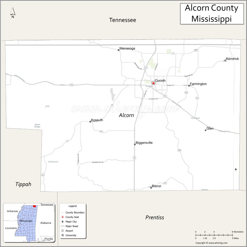
About Alcorn County Map, Mississippi: The map showing the county boundary, county seat, major cities, highways, water bodies and neighbouring counties.
Other Mississippi Maps & Info
Alcorn County, Mississippi
Alcorn County is a county located in the U.S. state of Mississippi. It's county seat is Corinth. As per 2020 census, the population of Alcorn County is 34349 people and population density is square miles. According to the United States Census Bureau, the county has a total area of 400 sq mi (1,036 km2). Alcorn County was established on 1870.
Alcorn County Facts
| Continent | North America |
| Country | United States |
| State | Mississippi |
| County Seat | Corinth |
| Largest City/Town | Corinth |
| Established | 1870 |
| Total Area | 401 sq mi (1,039 sq km) |
| Land Area | 400 sq mi (1,036 sq km) |
| Water Area | 1 sq mi (2.6 sq km) |
| Population | 34,740 (Census 2020) |
| Population Density | 86.9 people per sq mi |
| Time Zone | Central Time Zone |
| Major Highways | U.S. Route 45, U.S. Route 72, Mississippi Highway 2 |
| Major Rivers | Tennessee River nearby region, Hatchie River nearby watershed |
| Neighboring Counties | Tippah County, Prentiss County, Tishomingo County, Hardin County (Tennessee), McNairy County (Tennessee) |
| Famous For | Civil War history, railroad heritage, and the city of Corinth |
| Top Attractions | Corinth Civil War Interpretive Center, Crossroads Museum, and Shiloh National Military Park nearby region |
| Official Website | Official Website |
About Alcorn County, Mississippi
Alcorn County is located in northeastern Mississippi along the Tennessee border and was established in 1870. The county seat and largest city is Corinth, a historic transportation crossroads known for its Civil War significance, railroad history, and vibrant community life. The county combines historical attractions with scenic North Mississippi landscapes.
Cities and Towns in Alcorn County, Mississippi
| City/Town | Population (Census 2020) | Latitude & Longitude |
|---|---|---|
| Corinth (county seat) | 14,622 | 34.9343°N, 88.5223°W |
| Farmington | 2,274 | 34.9306°N, 88.4517°W |
| Glen | 361 | 34.8595°N, 88.4009°W |
| Rienzi | 317 | 34.7640°N, 88.5348°W |
Golf Courses in Alcorn County, Mississippi
| Golf Course | Location | Latitude & Longitude |
|---|---|---|
| Hillandale Golf Course | Corinth | 34.9488°N, 88.5379°W |
| Shiloh Ridge Golf & Athletic Club nearby region | Pickwick area | 35.0167°N, 88.2500°W |
What Are the Major Roads and Highways in Alcorn County, Mississippi
Major highways make Alcorn County an important transportation hub in northeastern Mississippi.
- U.S. Route 45 - major north-south highway connecting Mississippi with Tennessee and Alabama
- U.S. Route 72 - important east-west route linking Mississippi, Alabama, and Tennessee
- Mississippi Highway 2 - scenic regional highway serving northern Mississippi communities
What are the Neighboring Counties of Alcorn County
- Tippah County (southwest)
- Prentiss County (south)
- Tishomingo County (east)
- Hardin County, Tennessee (north)
- McNairy County, Tennessee (northwest)
What Are the Top Attractions in Alcorn County, Mississippi
The county offers a blend of historical, cultural, and recreational attractions.
- Corinth Civil War Interpretive Center - museum and exhibits focused on Civil War battles and railroad history
- Crossroads Museum - local museum highlighting railroad heritage and regional culture
- Shiloh National Military Park Nearby Region - preserved Civil War battlefield and historic landmarks
- Historic Downtown Corinth - local shops, restaurants, murals, and historic architecture
- Battery Robinett - important Civil War earthworks and memorial site
- Corinth Contraband Camp Site - historical landmark connected to African American Civil War history
- Hillandale Park - recreation area with sports fields, walking trails, and picnic facilities
- Pickwick Lake Nearby Region - boating, fishing, camping, and water recreation opportunities
- Crossroads Arena - venue for community events, concerts, and regional gatherings
- Scenic North Mississippi Drives - countryside routes featuring rolling hills and forest landscapes
Distance from Alcorn County to Nearby Cities
The following distances are measured by road (driving).
- Corinth to Tupelo, Mississippi - 52 mi (84 km)
- Corinth to Jackson, Tennessee - 84 mi (135 km)
- Corinth to Memphis, Tennessee - 94 mi (151 km)
- Corinth to Florence, Alabama - 73 mi (117 km)
- Corinth to Huntsville, Alabama - 118 mi (190 km)
- Corinth to Nashville, Tennessee - 211 mi (340 km)
- Corinth to Birmingham, Alabama - 171 mi (275 km)
- Corinth to Jackson, Mississippi - 228 mi (367 km)
- Corinth to Little Rock, Arkansas - 235 mi (378 km)
- Corinth to Atlanta, Georgia - 306 mi (492 km)
- Corinth to New Orleans, Louisiana - 396 mi (637 km)
- Corinth to St. Louis, Missouri - 358 mi (576 km)
FAQs about Alcorn County
Alcorn County is located in northeastern Mississippi along the Tennessee border.
Alcorn County had a population of 34,740 according to Census 2020 data.
Alcorn County is known for Civil War history, railroad heritage, and the historic city of Corinth.
The county is served by U.S. Route 45, U.S. Route 72, and Mississippi Highway 2.
Yes, Alcorn County has golf facilities including Hillandale Golf Course and nearby Pickwick area golf clubs.
References
- QuickFacts - U.S. Census Bureau
- United States Census Bureau
- Shiloh National Military Park
- Corinth Civil War Interpretive Center
- Official County Website
- Adams County Map
- Alcorn County Map
- Amite County Map
- Attala County Map
- Benton County Map
- Bolivar County Map
- Calhoun County Map
- Carroll County Map
- Chickasaw County Map
- Choctaw County Map
- Claiborne County Map
- Clarke County Map
- Clay County Map
- Coahoma County Map
- Copiah County Map
- Covington County Map
- DeSoto County Map
- Forrest County Map
- Franklin County Map
- George County Map
- Greene County Map
- Grenada County Map
- Hancock County Map
- Harrison County Map
- Hinds County Map
- Holmes County Map
- Humphreys County Map
- Issaquena County Map
- Itawamba County Map
- Jackson County Map
- Jasper County Map
- Jefferson County Map
- Jefferson Davis County Map
- Jones County Map
- Kemper County Map
- Lafayette County Map
- Lamar County Map
- Lauderdale County Map
- Lawrence County Map
- Leake County Map
- Lee County Map
- Leflore County Map
- Lincoln County Map
- Lowndes County Map
- Madison County Map
- Marion County Map
- Marshall County Map
- Monroe County Map
- Montgomery County Map
- Neshoba County Map
- Newton County Map
- Noxubee County Map
- Oktibbeha County Map
- Panola County Map
- Pearl River County Map
- Perry County Map
- Pike County Map
- Pontotoc County Map
- Prentiss County Map
- Quitman County Map
- Rankin County Map
- Scott County Map
- Sharkey County Map
- Simpson County Map
- Smith County Map
- Stone County Map
- Sunflower County Map
- Tallahatchie County Map
- Tate County Map
- Tippah County Map
- Tishomingo County Map
- Tunica County Map
- Union County Map
- Walthall County Map
- Warren County Map
- Washington County Map
- Wayne County Map
- Webster County Map
- Wilkinson County Map
- Winston County Map
- Yalobusha County Map
- Yazoo County Map
- Alabama Counties
- Alaska boroughs
- Arizona Counties
- Arkansas Counties
- California County Map
- Colorado Counties
- Connecticut Counties
- Delaware Counties
- Florida County Map
- Georgia County Map
- Hawaii Counties
- Idaho Counties
- Illinois Counties
- Indiana Counties
- Iowa Counties
- Kansas Counties
- Kentucky Counties
- Louisiana Counties
- Maine Counties
- Maryland Counties
- Massachusetts Counties
- Michigan County Map
- Minnesota Counties
- Mississippi Counties
- Missouri Counties
- Montana Counties
- Nebraska Counties
- Nevada Counties
- New York Counties
- New Hampshire Counties
- New Jersey Counties
- New Mexico Counties
- North Carolina Counties
- North Dakota Counties
- Ohio County Map
- Oklahoma Counties
- Oregon Counties
- Pennsylvania Counties
- Rhode Island Counties
- South Carolina Counties
- South Dakota Counties
- Map of Tennessee
- Texas County Map
- Utah Counties
- Vermont Counties
- Virginia Counties
- Washington Counties
- West Virginia Counties
- Wisconsin Counties
- Wyoming Counties