Written and Fact-checked by Whereig Editors, Reviewed by Mukesh Kumar| Last Updated On: May 12, 2026
Map of Lee County - Lee County is a county located in the U.S. state of Mississippi. Lee County Map showing cities, highways, important places and water bodies. Get Where is Lee County located in the map, major cities in Lee county, population, areas, and places of interest.
Map of Lee County, Mississippi
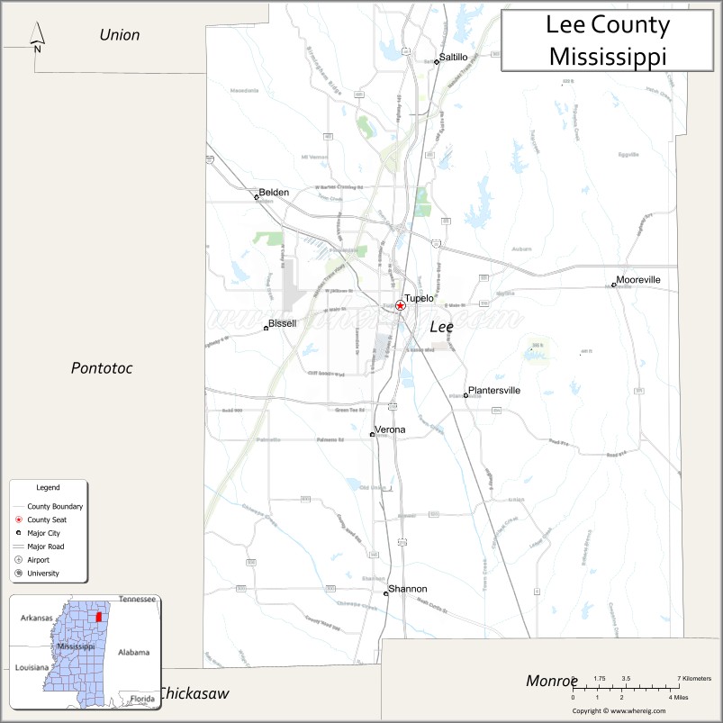
About Lee County Map, Mississippi: The map showing the county boundary, county seat, major cities, highways, water bodies and neighbouring counties.
Other Mississippi Maps & Info
Lee County, Mississippi
Lee County is a county located in the U.S. state of Mississippi. It's county seat is Tupelo. As per 2020 census, the population of Lee County is 82883 people and population density is square miles. According to the United States Census Bureau, the county has a total area of 450 sq mi (1,165 km2). Lee County was established on 1866.
Lee County Facts
| Continent | North America |
| Country | United States |
| State | Mississippi |
| County Seat | Tupelo |
| Largest City/Town | Tupelo |
| Established | 1866 |
| Total Area | 453 sq mi (1,173 sq km) |
| Land Area | 450 sq mi (1,166 sq km) |
| Water Area | 3 sq mi (7 sq km) |
| Population | 83,343 (Census 2020) |
| Population Density | 185.2 people per sq mi |
| Time Zone | Central Time Zone |
| Major Highways | Interstate 22, U.S. Route 45, Mississippi Highway 6 |
| Major Rivers | Tombigbee River nearby watershed, Natubby Creek |
| Neighboring Counties | Pontotoc County, Itawamba County, Union County, Prentiss County, Chickasaw County |
| Famous For | Elvis Presley birthplace, manufacturing, and Tupelo music heritage |
| Top Attractions | Elvis Presley Birthplace, Tupelo Buffalo Park, and Tupelo Automobile Museum nearby region |
| Official Website | Official Website |
About Lee County, Mississippi
Lee County is located in northeastern Mississippi and was established in 1866. The county seat and largest city is Tupelo, a major commercial and cultural center in north Mississippi. Lee County is nationally known as the birthplace of Elvis Presley and is recognized for manufacturing, healthcare, education, and regional tourism attractions.
Cities and Towns in Lee County, Mississippi
| City/Town | Population (Census 2020) | Latitude & Longitude |
|---|---|---|
| Tupelo (county seat) | 37,923 | 34.2576°N, 88.7034°W |
| Saltillo | 5,922 | 34.3765°N, 88.6809°W |
| Guntown | 2,410 | 34.4437°N, 88.6598°W |
| Plantersville | 1,104 | 34.2109°N, 88.6642°W |
| Verona | 2,955 | 34.1865°N, 88.7195°W |
| Shannon | 1,790 | 34.1195°N, 88.7167°W |
Golf Courses in Lee County, Mississippi
| Golf Course | Location | Latitude & Longitude |
|---|---|---|
| Tupelo National Golf Club | Tupelo | 34.3124°N, 88.7381°W |
| Big Oaks Golf Club | Saltillo | 34.3688°N, 88.6844°W |
| North Mississippi Golf Facilities nearby region | Tupelo region | 34.2607°N, 88.7075°W |
What Are the Major Roads and Highways in Lee County
Major highways make Lee County a transportation and economic center in northeastern Mississippi.
- Interstate 22 - major east-west corridor linking Memphis and Birmingham
- U.S. Route 45 - important north-south transportation route through Tupelo
- Mississippi Highway 6 - regional connector serving northern Mississippi communities
What are the Neighboring Counties of Lee County
- Union County (north)
- Prentiss County (northeast)
- Itawamba County (east)
- Chickasaw County (south)
- Pontotoc County (west)
What Are the Top Attractions in Lee County
The county offers music history, family entertainment, museums, and outdoor recreation.
- Elvis Presley Birthplace - historic home and museum honoring the King of Rock and Roll
- Tupelo Buffalo Park and Zoo - family attraction featuring exotic animals and safari experiences
- Tupelo Automobile Museum Nearby Region - classic car collection and transportation exhibits
- Downtown Tupelo Historic District - shopping, restaurants, entertainment venues, and murals
- BancorpSouth Arena - concerts, sporting events, and regional entertainment venue
- Tupelo National Battlefield - Civil War historical site preserving military history
- Natchez Trace Parkway Nearby Region - scenic driving route with hiking and historical landmarks
- Ballard Park - community recreation area with walking trails and sports facilities
- HealthWorks! Kids Museum - interactive educational attraction for children and families
- Annual Elvis Festival and Music Events - celebrations highlighting Tupelo’s musical heritage
Distance from Lee County to Nearby Cities
The following distances are measured by road (driving).
- Tupelo to Oxford, Mississippi - 52 mi (84 km)
- Tupelo to Starkville, Mississippi - 60 mi (97 km)
- Tupelo to Memphis, Tennessee - 109 mi (175 km)
- Tupelo to Birmingham, Alabama - 124 mi (200 km)
- Tupelo to Jackson, Mississippi - 180 mi (290 km)
- Tupelo to Nashville, Tennessee - 210 mi (338 km)
- Tupelo to Huntsville, Alabama - 116 mi (187 km)
- Tupelo to Little Rock, Arkansas - 213 mi (343 km)
- Tupelo to Atlanta, Georgia - 277 mi (446 km)
- Tupelo to New Orleans, Louisiana - 354 mi (570 km)
- Tupelo to Dallas, Texas - 458 mi (737 km)
- Tupelo to Houston, Texas - 518 mi (834 km)
FAQs about Lee County
Lee County is located in northeastern Mississippi.
Lee County had a population of 83,343 according to Census 2020 data.
Lee County is known for the Elvis Presley birthplace, manufacturing, and Tupelo music heritage.
The county is served by Interstate 22, U.S. Route 45, and Mississippi Highway 6.
Yes, Lee County has golf facilities including Tupelo National Golf Club and Big Oaks Golf Club.
References
- QuickFacts - U.S. Census Bureau
- United States Census Bureau
- Official County Website
- Elvis Presley Birthplace
- Visit Tupelo
- Adams County Map
- Alcorn County Map
- Amite County Map
- Attala County Map
- Benton County Map
- Bolivar County Map
- Calhoun County Map
- Carroll County Map
- Chickasaw County Map
- Choctaw County Map
- Claiborne County Map
- Clarke County Map
- Clay County Map
- Coahoma County Map
- Copiah County Map
- Covington County Map
- DeSoto County Map
- Forrest County Map
- Franklin County Map
- George County Map
- Greene County Map
- Grenada County Map
- Hancock County Map
- Harrison County Map
- Hinds County Map
- Holmes County Map
- Humphreys County Map
- Issaquena County Map
- Itawamba County Map
- Jackson County Map
- Jasper County Map
- Jefferson County Map
- Jefferson Davis County Map
- Jones County Map
- Kemper County Map
- Lafayette County Map
- Lamar County Map
- Lauderdale County Map
- Lawrence County Map
- Leake County Map
- Lee County Map
- Leflore County Map
- Lincoln County Map
- Lowndes County Map
- Madison County Map
- Marion County Map
- Marshall County Map
- Monroe County Map
- Montgomery County Map
- Neshoba County Map
- Newton County Map
- Noxubee County Map
- Oktibbeha County Map
- Panola County Map
- Pearl River County Map
- Perry County Map
- Pike County Map
- Pontotoc County Map
- Prentiss County Map
- Quitman County Map
- Rankin County Map
- Scott County Map
- Sharkey County Map
- Simpson County Map
- Smith County Map
- Stone County Map
- Sunflower County Map
- Tallahatchie County Map
- Tate County Map
- Tippah County Map
- Tishomingo County Map
- Tunica County Map
- Union County Map
- Walthall County Map
- Warren County Map
- Washington County Map
- Wayne County Map
- Webster County Map
- Wilkinson County Map
- Winston County Map
- Yalobusha County Map
- Yazoo County Map
- Alabama Counties
- Alaska boroughs
- Arizona Counties
- Arkansas Counties
- California County Map
- Colorado Counties
- Connecticut Counties
- Delaware Counties
- Florida County Map
- Georgia County Map
- Hawaii Counties
- Idaho Counties
- Illinois Counties
- Indiana Counties
- Iowa Counties
- Kansas Counties
- Kentucky Counties
- Louisiana Counties
- Maine Counties
- Maryland Counties
- Massachusetts Counties
- Michigan County Map
- Minnesota Counties
- Mississippi Counties
- Missouri Counties
- Montana Counties
- Nebraska Counties
- Nevada Counties
- New York Counties
- New Hampshire Counties
- New Jersey Counties
- New Mexico Counties
- North Carolina Counties
- North Dakota Counties
- Ohio County Map
- Oklahoma Counties
- Oregon Counties
- Pennsylvania Counties
- Rhode Island Counties
- South Carolina Counties
- South Dakota Counties
- Map of Tennessee
- Texas County Map
- Utah Counties
- Vermont Counties
- Virginia Counties
- Washington Counties
- West Virginia Counties
- Wisconsin Counties
- Wyoming Counties