
Where is Natchez Located? - Natchez is a city located in the Adams County of Mississippi, United States. Natchez lies between 36.0966897 Degrees North latitudes and 115.0407412 Degrees West longitudes.
Location Map of Natchez, Mississippi
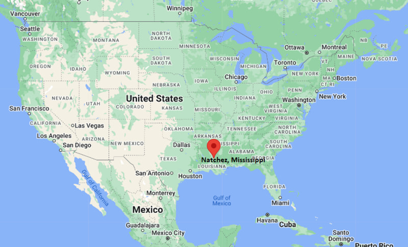
Natchez Map, Mississippi, USA
Where is Natchez?: The Google Map showing the location of Natchez in the U.S. state of Mississippi.
Where is Natchez Located?
Natchez is a city located in the Adams County of Mississippi, United States. Natchez lies between 36.0966897 Degrees North latitudes and 115.0407412 Degrees West longitudes. According to 2020 U.S.census, the population of Natchez city is 14520 people and the city has a total area of 15.81 sq mi. The city has numerous parks and recreational facilities.
Most Viewed US Maps
| USA Sttae Map | USA Region Map | USA Road Map |
| USA County Map | Where is USA in World Map? | US ZIP Code Map |
| USA Time Zones Map | US State and Capitals Map | USA Physical Map |
Find 4,400+ U.S. Cities by State - Explore Their Locations and Get Detailed Information
Natchez, Mississippi Quick Facts
| Attribute | Information |
|---|---|
| City | Natchez |
| County | Adams County |
| State | Mississippi |
| State Capital | Jackson |
| US Region | South (East South Central) |
| Latitude | 31.5604° N |
| Longitude | 91.4032° W |
| Elevation | 200 ft (61 m) |
| Land Area | 13.98 sq mi |
| Water Area | 2.05 sq mi |
| Total Area | 16.03 sq mi |
| Population (2020 Census) | 14,520 |
| Population Density | Approximately 1,038 per sq mi |
| ZIP Codes | 39120 |
| Area Code | 601 |
| Time Zone Standard | Central Standard Time (CST, UTC−6) |
| Time Zone Daylight | Central Daylight Time (CDT, UTC−5) |
| Currency | United States Dollar (USD) |
| FIPS Code | 28-50400 |
| Congressional District | Mississippi's 3rd Congressional District |
Transportation and Connectivity in Natchez
| Category | Information |
|---|---|
| Airport Name | Natchez-Adams County Airport |
| IATA Code | HEZ |
| Nearest Major Airport | Baton Rouge Metropolitan Airport |
| Port | Natchez Mississippi River Port |
| Major Highways | U.S. Highway 61, U.S. Highway 84, Mississippi Highway 555 |
| Train Service | Nearest Amtrak service available in Brookhaven |
| Local Transit Service | Natchez Transit System |
- U.S. Highway 61 – Historic north–south route connecting Natchez with Vicksburg, Mississippi and Louisiana communities.
- U.S. Highway 84 – Regional highway connecting Natchez with central Mississippi and Louisiana.
- Natchez-Adams County Airport provides general aviation services.
- The Mississippi River provides historic transportation and shipping connections.
Top Places to Visit in Natchez, Mississippi
| Landmark Name | Type |
|---|---|
| Natchez National Historical Park | Historic Park |
| Longwood | Historic Mansion |
| Stanton Hall | Historic Mansion |
| Rosalie Mansion | Historic House Museum |
| Melrose Estate | Historic Site |
| Natchez Trace Parkway | Scenic Parkway |
| Grand Village of the Natchez Indians | Archaeological Site |
| Natchez Museum of African American History and Culture | Museum |
| Under-the-Hill Historic District | Historic District |
| Bluff Park | Riverfront Park |
Driving Distances from Natchez, Mississippi to Nearby Cities
| City | State | Distance (mi) | Approx. Drive Time |
|---|---|---|---|
| Vidalia | Louisiana | 5 | 10 minutes |
| Ferriday | Louisiana | 15 | 25 minutes |
| Vicksburg | Mississippi | 90 | 1 hour 30 minutes |
| Baton Rouge | Louisiana | 90 | 1 hour 30 minutes |
| Jackson | Mississippi | 105 | 1 hour 45 minutes |
| Alexandria | Louisiana | 120 | 2 hours |
| New Orleans | Louisiana | 175 | 3 hours |
| Shreveport | Louisiana | 200 | 3 hours |
| Memphis | Tennessee | 260 | 4 hours |
| Birmingham | Alabama | 250 | 4 hours |
Colleges and Universities Near Natchez, Mississippi
| Institution Name | Type | Level | Notable For |
|---|---|---|---|
| Copiah-Lincoln Community College – Natchez Campus | Public | Community College | Associate degrees, technical programs, and workforce training |
| Alcorn State University | Public | University | Agriculture, education, business, and sciences |
| University of Louisiana at Monroe | Public | University | Pharmacy, business, education, and health sciences |
| Louisiana State University | Public | University | Research, engineering, agriculture, and professional programs |
| Mississippi College | Private | University | Law, health sciences, business, and liberal arts |
Waterbodies Near Natchez, Mississippi
Mississippi River, St. Catherine Creek, Foster Creek, Second Creek, and nearby waterways of the lower Mississippi River Valley.
Stadiums and Sports Facilities in Natchez
Natchez High School athletic facilities, Natchez-Adams School District sports fields, Duncan Park recreation facilities, and local community sports complexes.
Natchez, Mississippi — Key Historical Facts
- Natchez was established by French settlers in 1716 and is one of the oldest European settlements along the Mississippi River.
- The city was named after the Natchez people, a Native American civilization that historically lived in the region.
- Natchez became an important river port and trading center because of its location on the Mississippi River.
- During the antebellum period, the city developed as a major center for cotton plantations and river commerce.
- Natchez preserved many historic mansions and buildings, making it one of the most important heritage destinations in the southern United States.
- Today, Natchez is recognized for its historic architecture, Mississippi River views, cultural festivals, museums, and heritage tourism.
References
- City of Natchez
- Adams County Government
- U.S. Census Bureau
- Visit Natchez
- Natchez National Historical Park
Other Mississippi Maps & Info
- Where is Aberdeen
- Where is Amory
- Where is Baldwyn
- Where is Batesville
- Where is Bay St. Louis
- Where is Biloxi
- Where is Booneville
- Where is Brandon
- Where is Brookhaven
- Where is Byram
- Where is Canton
- Where is Carthage
- Where is Clarksdale
- Where is Cleveland
- Where is Clinton
- Where is Columbia
- Where is Columbus
- Where is Corinth
- Where is Crystal Springs
- Where is D'Iberville
- Where is Diamondhead
- Where is Ellisville
- Where is Florence
- Where is Flowood
- Where is Forest
- Where is Fulton
- Where is Gautier
- Where is Greenville
- Where is Greenwood
- Where is Grenada
- Where is Gulf Hills
- Where is Gulfport
- Where is Hattiesburg
- Where is Hazlehurst
- Where is Hernando
- Where is Holly Springs
- Where is Horn Lake
- Where is Houston
- Where is Indianola
- Where is Iuka
- Where is Jackson
- Where is Kosciusko
- Where is Laurel
- Where is Leland
- Where is Long Beach
- Where is Louisville
- Where is Madison
- Where is Magee
- Where is McComb
- Where is Meridian
- Where is Morton
- Where is Moss Point
- Where is Natchez
- Where is New Albany
- Where is Newton
- Where is Ocean Springs
- Where is Olive Branch
- Where is Oxford
- Where is Pass Christian
- Where is Pascagoula
- Where is Pearl
- Where is Petal
- Where is Philadelphia
- Where is Picayune
- Where is Pontotoc
- Where is Richland
- Where is Ridgeland
- Where is Ripley
- Where is Ruleville
- Where is Saltillo
- Where is Senatobia
- Where is Southaven
- Where is St. Martin
- Where is Starkville
- Where is Tupelo
- Where is Tutwiler
- Where is Verona
- Where is Vicksburg
- Where is Water Valley
- Where is Waveland
- Where is Waynesboro
- Where is West Point
- Where is Wiggins
- Where is Winona
- Where is Yazoo City