
Solvang is a small city in the Santa Ynez Valley of Central California and part of Santa Barbara County. Located about 35 miles northwest of Santa Barbara, the city is known for its Danish-inspired architecture, bakeries, windmills, vineyards, and historic Mission Santa Inés. Its valley setting also places it near Los Olivos, Buellton, and the Santa Ynez Mountains.
Location Map of Solvang, Santa Barbara County, California
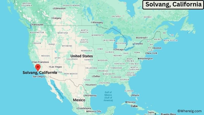
About Map: The map shows the location of Solvang in Santa Barbara County, in the U.S. state of California.
Solvang Map, California
About Solvang Map: The Google Map highlights the location of Solvang in Santa Barbara County, California. Use the zoom, satellite, and street-view options to explore the city's neighborhoods, roads, and nearby places.
Where is Solvang Located?
Solvang is a city located in Santa Barbara County, California, the United States. It lies in the Santa Ynez Valley along the central California coast, about 35 miles northwest of Santa Barbara and 15 miles north of Lompoc. Los Olivos is about 5 miles southeast, while Buellton is roughly 5 miles west of Solvang. The city is located at 34.5958° North latitude and 120.1376° West longitude. The 2020 Census recorded 6,126 residents. Solvang covers about 2.43 square miles (6.29 square kilometers), with nearly all of its area consisting of land. The surrounding valley includes vineyards, oak woodlands, rolling hills, and the Santa Ynez Mountains. Mission Santa Inés, founded in 1804, is one of the city's most important historic landmarks. Solvang is also known for its Danish-style buildings, windmills, bakeries, and traditional architecture. A unique feature of the city is its strong Danish heritage, established by Danish immigrants in the early 20th century and reflected throughout its downtown streets.
Most Viewed US Maps
| USA Sttae Map | USA Region Map | USA Road Map |
| USA County Map | Where is USA in World Map? | US ZIP Code Map |
| USA Time Zones Map | US State and Capitals Map | USA Physical Map |
Find 4,400+ U.S. Cities by State - Explore Their Locations and Get Detailed Information
Solvang City Facts
| Fact | Details |
|---|---|
| City | Solvang |
| State | California |
| County | Santa Barbara County |
| Country | United States |
| Region | Santa Ynez Valley, Central California |
| Incorporated | May 1, 1985 |
| Founded | 1911 |
| Total Area | 2.43 sq mi (6.29 sq km) |
| Land Area | 2.42 sq mi (6.27 sq km) |
| Water Area | 0.01 sq mi (0.02 sq km) |
| Elevation | About 505 ft (154 m) |
| Population (2023 estimate) | About 6,000 |
| Population (2020 Census) | 6,126 |
| Population Density | About 2,531 people per sq mi |
| Time Zone | Pacific Time (PST/PDT) |
| ZIP Codes | 93460, 93463 |
| Area Code | 805, 820 |
| Major Highways | U.S. Highway 101, California State Route 246 |
| Public Transit | Santa Ynez Valley Transit |
| Major Attractions | Mission Santa Inés, Solvang Village, Elverhøj Museum, Hans Christian Andersen Museum |
| Official Website | https://www.cityofsolvang.com/ |
Distance from Solvang, CA to Nearby Cities
- Buellton, CA – 5 miles (8 km)
- Los Olivos, CA – 5 miles (8 km)
- Santa Ynez, CA – 5 miles (8 km)
- Lompoc, CA – 15 miles (24 km)
- Goleta, CA – 30 miles (48 km)
- Santa Barbara, CA – 35 miles (56 km)
- Carpinteria, CA – 40 miles (64 km)
- Guadalupe, CA – 40 miles (64 km)
- Santa Maria, CA – 35 miles (56 km)
- Orcutt, CA – 35 miles (56 km)
- Pismo Beach, CA – 55 miles (89 km)
- San Luis Obispo, CA – 65 miles (105 km)
- Oxnard, CA – 75 miles (121 km)
- Ventura, CA – 70 miles (113 km)
- Morro Bay, CA – 80 miles (129 km)
- San Buenaventura, CA – 70 miles (113 km)
- Santa Monica, CA – 125 miles (201 km)
- Los Angeles, CA – 130 miles (209 km)
Top Attractions in Solvang, California
- Mission Santa Inés – A historic Spanish mission founded in 1804 and one of the oldest missions in California, with preserved buildings, gardens, artwork, and a museum.
- Solvang Village – The historic downtown area features Danish-inspired architecture, windmills, bakeries, restaurants, shops, and streets designed around the city's cultural heritage.
- Elverhøj Museum of History & Art – A local museum housed in a Danish-style building that preserves Solvang's Danish-American history, art, and cultural traditions.
- Hans Christian Andersen Museum – A small museum dedicated to the famous Danish author and his literary works.
- Solvang Vintage Motorcycle Museum – A collection of historic motorcycles displayed in a downtown location and covering several decades of motorcycle history.
- Old Mission Santa Inés Historical Park – The mission grounds include historic structures, gardens, religious artifacts, and views of the Santa Ynez Valley.
- Santa Ynez Valley Wine Country – Vineyards and wineries surround Solvang and form a major part of the agricultural landscape of the valley.
- Nojoqui Falls Park – A nearby wooded park featuring a seasonal waterfall, hiking trails, picnic areas, and shaded canyon scenery.
- Figueroa Mountain – A prominent nearby mountain area offering hiking, scenic drives, wildflower displays, and views across the Santa Ynez Valley.
Airports Near Solvang, California
- Santa Ynez Airport (IZA) – 5 miles
- Santa Maria Public Airport (SMX) – 40 miles
- Santa Barbara Airport (SBA) – 35 miles
- San Luis Obispo County Regional Airport (SBP) – 75 miles
Sources:
Population and area data sourced from the United States Census Bureau (2020 Census). General city information referenced from the official Solvang city website and local government records.
California Related Links
- Where is Los Angeles
- Where is San Diego
- Where is San Francisco
- Where is Anaheim
- Where is Bakersfield
- Where is Chula Vista
- Where is Freemont
- Where is Fresno
- Where is Glendale
- Where is Irvine
- Where is Long Beach
- Where is Modesto
- Where is Oakland
- Where is Paradise
- Where is Riverside
- Where is Sacramento
- Where is San Bernardino
- Where is San Jose
- Where is Santa Ana
- Where is Stockton
- Where is Berkeley
- Where is Clovis
- Where is Corona
- Where is Elk Grove
- Where is Escondido
- Where is Fontana
- Where is Fremont
- Where is Fullerton
- Where is Garden Grove
- Where is Hayward
- Where is Huntington Beach
- Where is Lancaster
- Where is Moreno Valley
- Where is Oceanside
- Where is Ontario
- Where is Orange
- Where is Oxnard
- Where is Palmdale
- Where is Pasadena
- Where is Pomona
- Where is Rancho Cucamonga
- Where is Roseville
- Where is Salinas
- Where is Santa Clara
- Where is Santa Clarita
- Where is Santa Rosa
- Where is Sunnyvale
- Where is Thousand Oaks
- Where is Torrance
- Where is Vallejo
- Where is Victorville
- Where is Visalia