By Whereig Editors, Reviewed by Mukesh Kumar| Updated On: May 02, 2026 | 20:16 ET
Map of Vanderburgh County - Vanderburgh County is a county located in the U.S. state of Indiana. Vanderburgh County Map showing cities, highways, important places and water bodies. Get Where is Vanderburgh County located in the map, major cities in Vanderburgh county, population, areas, and places of interest.
Map of Vanderburgh County, Indiana
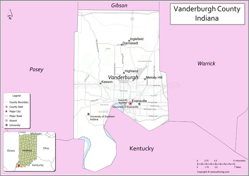
About Vanderburgh County Map, Alabama: The map showing the county boundary, county seat, major cities, highways, water bodies and neighbouring counties.
Related Indiana Maps
About Vanderburgh County, Indiana
Wayne County is a county located in the U.S. state of Indiana. It`s county seat is Richmond. As per 2020 census, the population of Wayne County was 66456 and population density of Wayne was square miles. According to the United States Census Bureau, the county has a total area of 402 sq mi (1,041 km2). Wayne County was established on -32540.
Vanderburgh County Facts
| Continent | North America |
| Country | United States |
| State | Indiana |
| County Seat | Evansville |
| Largest City/Town | Evansville |
| Established | 1818 |
| Total Area | 236 sq mi (611 sq km) |
| Land Area | 233 sq mi (603 sq km) |
| Water Area | 3 sq mi (8 sq km) |
| Population | 179,703 (Census 2020) |
| Population Density | 771 people per sq mi |
| Time Zone | Central Time Zone (CT) |
| Major Highways | I-69, I-64, US-41, SR-62, SR-66 |
| Neighboring Counties | Posey County, Gibson County, Warrick County (IN); Henderson County (KY) |
| Famous For | Evansville riverfront, manufacturing, cultural sites, Ohio River access |
| Top Attractions | Mesker Park Zoo, Evansville Museum, Wesselman Woods, USS LST-325, Tropicana Evansville |
| Official Website | https://www.evansvillegov.org |
Cities and Towns in Barnstable County, Massachusetts
- Barnstable (county seat) – 48,916 (Census 2020)
- Bourne – 20,452 (Census 2020)
- Brewster – 10,318 (Census 2020)
- Chatham – 6,594 (Census 2020)
- Dennis – 14,674 (Census 2020)
- Eastham – 5,752 (Census 2020)
- Falmouth – 32,517 (Census 2020)
- Harwich – 13,440 (Census 2020)
- Mashpee – 14,006 (Census 2020)
- Orleans – 5,920 (Census 2020)
- Provincetown – 3,664 (Census 2020)
- Sandwich – 20,259 (Census 2020)
- Truro – 2,454 (Census 2020)
- Wellfleet – 3,566 (Census 2020)
- Yarmouth – 25,417 (Census 2020)
Roads and Highways in Vanderburgh County, Indiana
Vanderburgh County is served by a strong highway network that connects it to major cities in Indiana, Kentucky, and the Midwest region.
- Interstate 69 – runs north to Indianapolis and south toward Kentucky
- Interstate 64 – connects west to St. Louis, Missouri and east to Louisville, Kentucky
- U.S. Route 41 – north-south route linking Evansville with Terre Haute and Henderson, Kentucky
- State Road 62 – connects Evansville to Mount Vernon and Newburgh
- State Road 66 – runs along the Ohio River connecting regional towns
Neighboring Counties of Vanderburgh County
- Posey County (west)
- Gibson County (north)
- Warrick County (east)
- Henderson County, Kentucky (south)
Top Attractions in Vanderburgh County, Indiana
The county offers a mix of outdoor recreation, museums, and family attractions centered around Evansville and the Ohio River.
- Mesker Park Zoo & Botanic Garden – a well-known zoo with a wide variety of animals and exhibits
- Evansville Museum of Arts, History & Science – features art collections and interactive science displays
- Wesselman Woods Nature Preserve – a large urban forest with peaceful walking trails
- USS LST-325 – a historic World War II ship open for public tours
- Tropicana Evansville – a riverfront casino and entertainment destination
- Children’s Museum of Evansville – hands-on exhibits for kids and families
- Garvin Park – a scenic park with a lake, playgrounds, and picnic areas
Distance from Vanderburgh County to Nearby Cities
- Evansville to Indianapolis – 170 mi (274 km)
- Evansville to Louisville – 120 mi (193 km)
- Evansville to St. Louis – 170 mi (274 km)
- Evansville to Nashville – 150 mi (241 km)
- Evansville to Chicago – 300 mi (483 km)
FAQs about Vanderburgh County
It is located in southwestern Indiana along the Ohio River, bordering Kentucky.
Evansville serves as both the county seat and largest city.
It is known for its riverfront, historic sites, and role as a regional economic center.
The county follows the Central Time Zone.
There is one city (Evansville) and one town (Darmstadt).
- Adams County Map, IN
- Allen County Map, IN
- Bartholomew County Map, IN
- Benton County Map, IN
- Blackford County Map, IN
- Boone County Map, IN
- Brown County Map, IN
- Carroll County Map, IN
- Cass County Map, IN
- Clark County Map, IN
- Clay County Map, IN
- Clinton County Map, IN
- Crawford County Map, IN
- Daviess County Map, IN
- Dearborn County Map, IN
- Decatur County Map, IN
- DeKalb County Map, IN
- Delaware County Map, IN
- Dubois County Map, IN
- Elkhart County Map, IN
- Fayette County Map, IN
- Floyd County Map, IN
- Fountain County Map, IN
- Franklin County Map, IN
- Fulton County Map, IN
- Gibson County Map, IN
- Grant County Map, IN
- Greene County Map, IN
- Hamilton County Map, IN
- Hancock County Map, IN
- Harrison County Map, IN
- Hendricks County Map, IN
- Henry County Map, IN
- Howard County Map, IN
- Huntington County Map, IN
- Jackson County Map, IN
- Jasper County Map, IN
- Jay County Map, IN
- Jefferson County Map, IN
- Jennings County Map, IN
- Johnson County Map, IN
- Knox County Map, IN
- Kosciusko County Map, IN
- LaGrange County Map, IN
- Lake County Map, IN
- LaPorte County Map, IN
- Lawrence County Map, IN
- Madison County Map, IN
- Marion County Map, IN
- Marshall County Map, IN
- Martin County Map, IN
- Miami County Map, IN
- Monroe County Map, IN
- Montgomery County Map, IN
- Morgan County Map, IN
- Newton County Map, IN
- Noble County Map, IN
- Ohio County Map, IN
- Orange County Map, IN
- Owen County Map, IN
- Parke County Map, IN
- Perry County Map, IN
- Pike County Map, IN
- Porter County Map, IN
- Posey County Map, IN
- Pulaski County Map, IN
- Putnam County Map, IN
- Randolph County Map, IN
- Ripley County Map, IN
- Rush County Map, IN
- St Joseph County Map, IN
- Scott County Map, IN
- Shelby County Map, IN
- Spencer County Map, IN
- Starke County Map, IN
- Steuben County Map, IN
- Sullivan County Map, IN
- Switzerland County Map, IN
- Tippecanoe County Map, IN
- Tipton County Map, IN
- Union County Map, IN
- Vanderburgh County Map, IN
- Vermillion County Map, IN
- Vigo County Map, IN
- Wabash County Map, IN
- Warren County Map, IN
- Warrick County Map, IN
- Washington County Map, IN
- Wayne County Map, IN
- Wells County Map, IN
- White County Map, IN
- Whitley County Map, IN
- Alabama Counties
- Alaska boroughs
- Arizona Counties
- Arkansas Counties
- California County Map
- Colorado Counties
- Connecticut Counties
- Delaware Counties
- Florida County Map
- Georgia County Map
- Hawaii Counties
- Idaho Counties
- Illinois Counties
- Indiana Counties
- Iowa Counties
- Kansas Counties
- Kentucky Counties
- Louisiana Counties
- Maine Counties
- Maryland Counties
- Massachusetts Counties
- Michigan County Map
- Minnesota Counties
- Mississippi Counties
- Missouri Counties
- Montana Counties
- Nebraska Counties
- Nevada Counties
- New York Counties
- New Hampshire Counties
- New Jersey Counties
- New Mexico Counties
- North Carolina Counties
- North Dakota Counties
- Ohio County Map
- Oklahoma Counties
- Oregon Counties
- Pennsylvania Counties
- Rhode Island Counties
- South Carolina Counties
- South Dakota Counties
- Map of Tennessee
- Texas County Map
- Utah Counties
- Vermont Counties
- Virginia Counties
- Washington Counties
- West Virginia Counties
- Wisconsin Counties
- Wyoming Counties