By Whereig Editors, Reviewed by Mukesh Kumar| Updated On: May 02, 2026 | 20:16 ET
Map of Vermillion County - Vermillion County is a county located in the U.S. state of Indiana. Vermillion County Map showing cities, highways, important places and water bodies. Get Where is Vermillion County located in the map, major cities in Vermillion county, population, areas, and places of interest.
Map of Vermillion County, Indiana
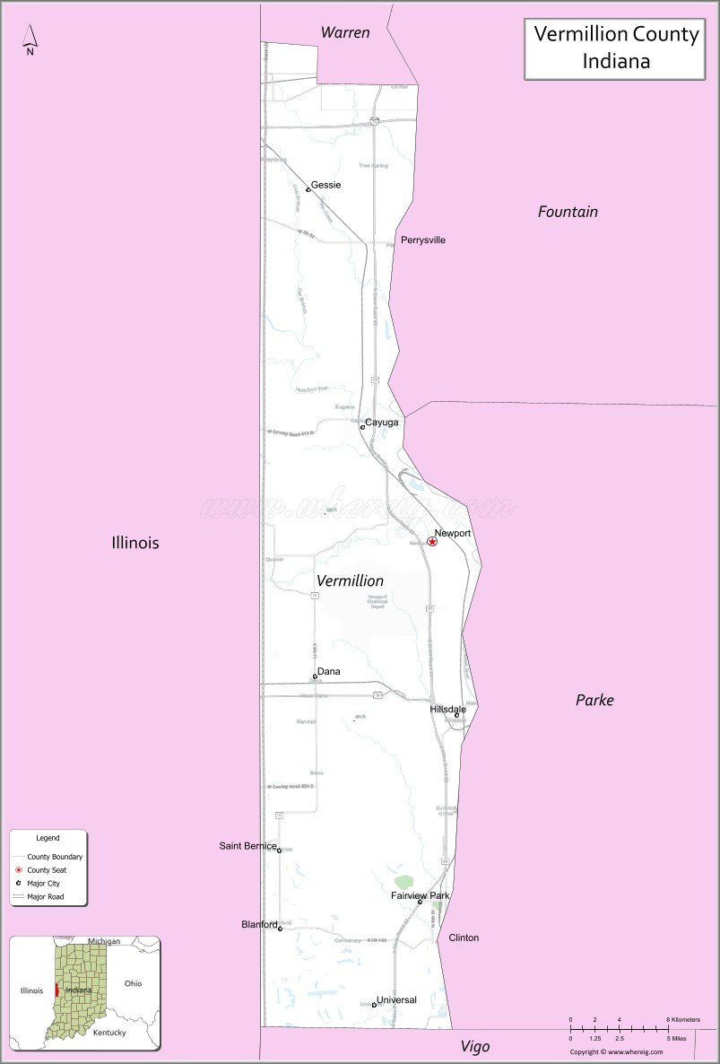
About Vermillion County Map, Alabama: The map showing the county boundary, county seat, major cities, highways, water bodies and neighbouring counties.
Related Indiana Maps
About Vermillion County, Indiana
Wells County is a county located in the U.S. state of Indiana. It`s county seat is Bluffton. As per 2020 census, the population of Wells County was 28197 and population density of Wells was square miles. According to the United States Census Bureau, the county has a total area of 368 sq mi (953 km2). Wells County was established on -22971.
Vermillion County Facts
| Continent | North America |
| Country | United States |
| State | Indiana |
| County Seat | Newport |
| Largest City/Town | Clinton |
| Established | 1824 |
| Total Area | 257 sq mi (665 sq km) |
| Land Area | 256 sq mi (663 sq km) |
| Water Area | 1.2 sq mi (3 sq km) |
| Population | 15,439 (Census 2020) |
| Population Density | 60 people per sq mi |
| Time Zone | Eastern Time Zone (ET) |
| Major Highways | US-36, SR-63, SR-71, SR-163 |
| Neighboring Counties | Vigo County, Parke County, Fountain County (IN); Edgar County, Vermilion County (IL) |
| Famous For | Coal mining history, Wabash River, historic towns |
| Top Attractions | Clinton Coal Heritage Museum, Newport Hill Climb, Wabash River, Sportland Park |
| Official Website | https://www.vermilliongov.us |
Cities and Towns in Vermillion County, Indiana
- Clinton – 4,893 (Census 2020)
- Cayuga – 1,134 (Census 2020)
- Dana – 555 (Census 2020)
- Fairview Park – 1,333 (Census 2020)
- Newport (county seat) – 492 (Census 2020)
- Perrysville – 456 (Census 2020)
- Universal – 326 (Census 2020)
Roads and Highways in Vermillion County, Indiana
Vermillion County is served by several state and U.S. highways that connect it to nearby Indiana counties and western Illinois.
- U.S. Route 36 – east-west route connecting to Terre Haute and Indianapolis
- State Road 63 – north-south highway linking to Lafayette and Terre Haute
- State Road 71 – connects Newport to southern parts of the county
- State Road 163 – links Clinton to nearby Illinois communities
Neighboring Counties of Vermillion County
- Parke County (north)
- Fountain County (northeast)
- Vigo County (south)
- Edgar County, Illinois (west)
- Vermilion County, Illinois (northwest)
Top Attractions in Vermillion County, Indiana
This county offers a mix of history, outdoor recreation, and local events tied to its coal mining heritage and river setting.
- Clinton Coal Heritage Museum – showcases the county’s rich mining history
- Newport Hill Climb – a famous annual motorsports event attracting visitors from across the region
- Wabash River – great for fishing, boating, and scenic views
- Sportland Park – a popular spot for recreation and local events
- Ernie Pyle State Historic Site – honors the life of the famous war correspondent
- Vermillion County Fairgrounds – hosts fairs, festivals, and community gatherings
- Raccoon Lake (nearby) – offers camping, boating, and outdoor activities
Distance from Vermillion County to Nearby Cities
- Clinton to Terre Haute – 15 mi (24 km)
- Clinton to Indianapolis – 75 mi (121 km)
- Clinton to Danville, IL – 30 mi (48 km)
- Clinton to Lafayette – 80 mi (129 km)
- Clinton to Chicago – 160 mi (257 km)
FAQs about Vermillion County
It is located in western Indiana along the border with Illinois.
Newport serves as the county seat.
Clinton is the largest town in the county.
The county is known for its coal mining history and the annual Newport Hill Climb event.
It follows the Eastern Time Zone.
- Adams County Map, IN
- Allen County Map, IN
- Bartholomew County Map, IN
- Benton County Map, IN
- Blackford County Map, IN
- Boone County Map, IN
- Brown County Map, IN
- Carroll County Map, IN
- Cass County Map, IN
- Clark County Map, IN
- Clay County Map, IN
- Clinton County Map, IN
- Crawford County Map, IN
- Daviess County Map, IN
- Dearborn County Map, IN
- Decatur County Map, IN
- DeKalb County Map, IN
- Delaware County Map, IN
- Dubois County Map, IN
- Elkhart County Map, IN
- Fayette County Map, IN
- Floyd County Map, IN
- Fountain County Map, IN
- Franklin County Map, IN
- Fulton County Map, IN
- Gibson County Map, IN
- Grant County Map, IN
- Greene County Map, IN
- Hamilton County Map, IN
- Hancock County Map, IN
- Harrison County Map, IN
- Hendricks County Map, IN
- Henry County Map, IN
- Howard County Map, IN
- Huntington County Map, IN
- Jackson County Map, IN
- Jasper County Map, IN
- Jay County Map, IN
- Jefferson County Map, IN
- Jennings County Map, IN
- Johnson County Map, IN
- Knox County Map, IN
- Kosciusko County Map, IN
- LaGrange County Map, IN
- Lake County Map, IN
- LaPorte County Map, IN
- Lawrence County Map, IN
- Madison County Map, IN
- Marion County Map, IN
- Marshall County Map, IN
- Martin County Map, IN
- Miami County Map, IN
- Monroe County Map, IN
- Montgomery County Map, IN
- Morgan County Map, IN
- Newton County Map, IN
- Noble County Map, IN
- Ohio County Map, IN
- Orange County Map, IN
- Owen County Map, IN
- Parke County Map, IN
- Perry County Map, IN
- Pike County Map, IN
- Porter County Map, IN
- Posey County Map, IN
- Pulaski County Map, IN
- Putnam County Map, IN
- Randolph County Map, IN
- Ripley County Map, IN
- Rush County Map, IN
- St Joseph County Map, IN
- Scott County Map, IN
- Shelby County Map, IN
- Spencer County Map, IN
- Starke County Map, IN
- Steuben County Map, IN
- Sullivan County Map, IN
- Switzerland County Map, IN
- Tippecanoe County Map, IN
- Tipton County Map, IN
- Union County Map, IN
- Vanderburgh County Map, IN
- Vermillion County Map, IN
- Vigo County Map, IN
- Wabash County Map, IN
- Warren County Map, IN
- Warrick County Map, IN
- Washington County Map, IN
- Wayne County Map, IN
- Wells County Map, IN
- White County Map, IN
- Whitley County Map, IN
- Alabama Counties
- Alaska boroughs
- Arizona Counties
- Arkansas Counties
- California County Map
- Colorado Counties
- Connecticut Counties
- Delaware Counties
- Florida County Map
- Georgia County Map
- Hawaii Counties
- Idaho Counties
- Illinois Counties
- Indiana Counties
- Iowa Counties
- Kansas Counties
- Kentucky Counties
- Louisiana Counties
- Maine Counties
- Maryland Counties
- Massachusetts Counties
- Michigan County Map
- Minnesota Counties
- Mississippi Counties
- Missouri Counties
- Montana Counties
- Nebraska Counties
- Nevada Counties
- New York Counties
- New Hampshire Counties
- New Jersey Counties
- New Mexico Counties
- North Carolina Counties
- North Dakota Counties
- Ohio County Map
- Oklahoma Counties
- Oregon Counties
- Pennsylvania Counties
- Rhode Island Counties
- South Carolina Counties
- South Dakota Counties
- Map of Tennessee
- Texas County Map
- Utah Counties
- Vermont Counties
- Virginia Counties
- Washington Counties
- West Virginia Counties
- Wisconsin Counties
- Wyoming Counties