By Whereig Editors, Reviewed by Mukesh Kumar| Updated On: May 02, 2026 | 20:16 ET
Map of Madison County - Madison County is a county located in the U.S. state of Indiana. Madison County Map showing cities, highways, important places and water bodies. Get Where is Madison County located in the map, major cities in Madison county, population, areas, and places of interest.
Map of Madison County, Indiana
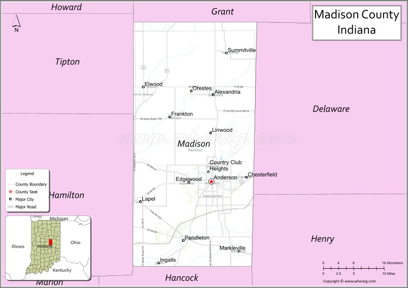
About Madison County Map, Alabama: The map showing the county boundary, county seat, major cities, highways, water bodies and neighbouring counties.
Related Indiana Maps
About Madison County, Indiana
Morgan County is a county located in the U.S. state of Indiana. It`s county seat is Martinsville. As per 2020 census, the population of Morgan County was 72206 and population density of Morgan was square miles. According to the United States Census Bureau, the county has a total area of 404 sq mi (1,046 km2). Morgan County was established on -28123.
Madison County Facts
| Continent | North America |
| Country | United States |
| State | Indiana |
| County Seat | Anderson |
| Largest City/Town | Anderson |
| Established | 1823 |
| Total Area | 453 sq mi |
| Land Area | 452 sq mi |
| Water Area | 1.3 sq mi |
| Population | 130,129 (Census 2020) |
| Population Density | 288 people per sq mi |
| Time Zone | Eastern Time Zone (ET) |
| Major Highways | I-69, IN-9, IN-13, IN-32, IN-38, IN-67 |
| Neighboring Counties | Grant County (north), Delaware County (east), Henry County (southeast), Hancock County (south), Hamilton County (west), Tipton County (northwest) |
| Famous For | Anderson, auto industry history, Mounds State Park |
| Top Attractions | Mounds State Park, Hoosier Park Racing & Casino, Anderson Speedway |
| Official Website | https://www.madisoncounty.in.gov/ |
Cities and Towns in Madison County, Indiana
- Anderson (county seat) – 54,788 (Census 2020)
- Elwood – 8,390 (Census 2020)
- Alexandria – 5,145 (Census 2020)
- Pendleton – 4,253 (Census 2020)
- Chesterfield – 2,547 (Census 2020)
- Edgewood – 2,083 (Census 2020)
- Lapel – 2,360 (Census 2020)
- Frankton – 1,799 (Census 2020)
- Summitville – 967 (Census 2020)
- Orestes – 329 (Census 2020)
Roads and Highways in Madison County, Indiana
Madison County is well connected by highways that link it to Indianapolis and northeastern Indiana.
- Interstate 69 (I-69) – major north-south route connecting Anderson to Indianapolis and Fort Wayne
- Indiana State Road 9 – north-south highway linking Anderson to Marion and Noblesville
- Indiana State Road 13 – connects the county to Elwood and surrounding areas
- Indiana State Road 32 – east-west route connecting Anderson to Muncie and Lebanon
- Indiana State Road 38 – links Pendleton to Noblesville and Richmond
- Indiana State Road 67 – connects the county to Muncie and Indianapolis
Neighboring Counties of Madison County
- Grant County (north)
- Delaware County (east)
- Henry County (southeast)
- Hancock County (south)
- Hamilton County (west)
- Tipton County (northwest)
Top Attractions in Madison County, Indiana
Madison County offers parks, entertainment, and a strong connection to Indiana’s industrial history.
- Mounds State Park – known for its ancient earthworks and scenic trails
- Hoosier Park Racing & Casino – horse racing and gaming venue in Anderson
- Anderson Speedway – historic short-track racing venue
- White River Greenway – trail system for walking and biking
- Historic Paramount Theatre – restored theater with live performances
- Shadyside Memorial Park – community park with river views
Distance from Madison County to Nearby Cities
- Madison County to Indianapolis – 40 mi (64 km)
- Madison County to Muncie – 20 mi (32 km)
- Madison County to Fort Wayne – 70 mi (113 km)
- Madison County to Kokomo – 35 mi (56 km)
- Madison County to Cincinnati – 100 mi (161 km)
FAQs about Madison County
Madison County is located in central Indiana.
The county seat is Anderson, which is also the largest city in the county.
It is known for its auto industry history, parks, and the city of Anderson.
Yes, it is part of the Indianapolis metropolitan area.
The county is served by I-69 and several Indiana state roads including IN-9 and IN-32.
- Adams County Map, IN
- Allen County Map, IN
- Bartholomew County Map, IN
- Benton County Map, IN
- Blackford County Map, IN
- Boone County Map, IN
- Brown County Map, IN
- Carroll County Map, IN
- Cass County Map, IN
- Clark County Map, IN
- Clay County Map, IN
- Clinton County Map, IN
- Crawford County Map, IN
- Daviess County Map, IN
- Dearborn County Map, IN
- Decatur County Map, IN
- DeKalb County Map, IN
- Delaware County Map, IN
- Dubois County Map, IN
- Elkhart County Map, IN
- Fayette County Map, IN
- Floyd County Map, IN
- Fountain County Map, IN
- Franklin County Map, IN
- Fulton County Map, IN
- Gibson County Map, IN
- Grant County Map, IN
- Greene County Map, IN
- Hamilton County Map, IN
- Hancock County Map, IN
- Harrison County Map, IN
- Hendricks County Map, IN
- Henry County Map, IN
- Howard County Map, IN
- Huntington County Map, IN
- Jackson County Map, IN
- Jasper County Map, IN
- Jay County Map, IN
- Jefferson County Map, IN
- Jennings County Map, IN
- Johnson County Map, IN
- Knox County Map, IN
- Kosciusko County Map, IN
- LaGrange County Map, IN
- Lake County Map, IN
- LaPorte County Map, IN
- Lawrence County Map, IN
- Madison County Map, IN
- Marion County Map, IN
- Marshall County Map, IN
- Martin County Map, IN
- Miami County Map, IN
- Monroe County Map, IN
- Montgomery County Map, IN
- Morgan County Map, IN
- Newton County Map, IN
- Noble County Map, IN
- Ohio County Map, IN
- Orange County Map, IN
- Owen County Map, IN
- Parke County Map, IN
- Perry County Map, IN
- Pike County Map, IN
- Porter County Map, IN
- Posey County Map, IN
- Pulaski County Map, IN
- Putnam County Map, IN
- Randolph County Map, IN
- Ripley County Map, IN
- Rush County Map, IN
- St Joseph County Map, IN
- Scott County Map, IN
- Shelby County Map, IN
- Spencer County Map, IN
- Starke County Map, IN
- Steuben County Map, IN
- Sullivan County Map, IN
- Switzerland County Map, IN
- Tippecanoe County Map, IN
- Tipton County Map, IN
- Union County Map, IN
- Vanderburgh County Map, IN
- Vermillion County Map, IN
- Vigo County Map, IN
- Wabash County Map, IN
- Warren County Map, IN
- Warrick County Map, IN
- Washington County Map, IN
- Wayne County Map, IN
- Wells County Map, IN
- White County Map, IN
- Whitley County Map, IN
- Alabama Counties
- Alaska boroughs
- Arizona Counties
- Arkansas Counties
- California County Map
- Colorado Counties
- Connecticut Counties
- Delaware Counties
- Florida County Map
- Georgia County Map
- Hawaii Counties
- Idaho Counties
- Illinois Counties
- Indiana Counties
- Iowa Counties
- Kansas Counties
- Kentucky Counties
- Louisiana Counties
- Maine Counties
- Maryland Counties
- Massachusetts Counties
- Michigan County Map
- Minnesota Counties
- Mississippi Counties
- Missouri Counties
- Montana Counties
- Nebraska Counties
- Nevada Counties
- New York Counties
- New Hampshire Counties
- New Jersey Counties
- New Mexico Counties
- North Carolina Counties
- North Dakota Counties
- Ohio County Map
- Oklahoma Counties
- Oregon Counties
- Pennsylvania Counties
- Rhode Island Counties
- South Carolina Counties
- South Dakota Counties
- Map of Tennessee
- Texas County Map
- Utah Counties
- Vermont Counties
- Virginia Counties
- Washington Counties
- West Virginia Counties
- Wisconsin Counties
- Wyoming Counties