By Whereig Editors, Reviewed by Mukesh Kumar| Updated On: May 02, 2026 | 20:16 ET
Map of Warrick County - Warrick County is a county located in the U.S. state of Indiana. Warrick County Map showing cities, highways, important places and water bodies. Get Where is Warrick County located in the map, major cities in Warrick county, population, areas, and places of interest.
Map of Warrick County, Indiana
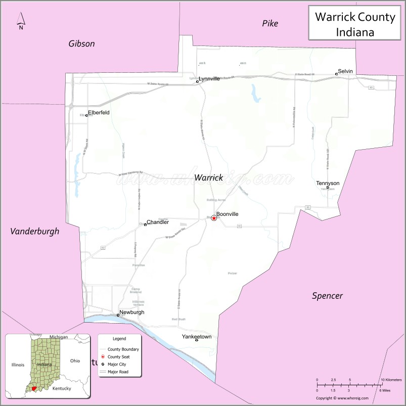
About Warrick County Map, Alabama: The map showing the county boundary, county seat, major cities, highways, water bodies and neighbouring counties.
Related Indiana Maps
About Warrick County, Indiana
Adams County is a county located in the U.S. state of Iowa. It`s county seat is Corning. As per 2020 census, the population of Adams County was 3641 and population density of Adams was square miles. According to the United States Census Bureau, the county has a total area of 424 sq mi (1,098 km2). Adams County was established on -17881.
Warrick County Facts
| Continent | North America |
| Country | United States |
| State | Indiana |
| County Seat | Boonville |
| Largest City/Town | Newburgh |
| Established | 1813 |
| Total Area | 391 sq mi (1,012 sq km) |
| Land Area | 384 sq mi (995 sq km) |
| Water Area | 7.3 sq mi (19 sq km) |
| Population | 63,898 (Census 2020) |
| Population Density | 166 people per sq mi |
| Time Zone | Central Time Zone (CT) |
| Major Highways | I-69, I-64, SR-62, SR-66, SR-261 |
| Neighboring Counties | Vanderburgh County, Spencer County, Pike County, Gibson County (IN); Henderson County (KY) |
| Famous For | Historic Newburgh riverfront, Ohio River views, Scales Lake Park |
| Top Attractions | Historic Newburgh, Scales Lake Park, Friedman Park, Angel Mounds (nearby) |
| Official Website | https://www.warrickcounty.gov |
Cities and Towns in Warrick County, Indiana
- Boonville (county seat) – 6,246 (Census 2020)
- Newburgh – 3,325 (Census 2020)
- Tennyson – 277 (Census 2020)
- Lynnville – 888 (Census 2020)
- Chandler – 3,096 (Census 2020)
Roads and Highways in Warrick County, Indiana
Warrick County is served by major interstates and state highways that connect it to Evansville, other parts of Indiana, and nearby Kentucky.
- Interstate 69 – runs north-south connecting Evansville to Indianapolis
- Interstate 64 – east-west route linking to St. Louis, Missouri and Louisville, Kentucky
- State Road 62 – connects Newburgh and Boonville to Evansville
- State Road 66 – follows the Ohio River connecting river communities
- State Road 261 – provides local access within the county and to nearby towns
Neighboring Counties of Warrick County
- Pike County (north)
- Gibson County (northwest)
- Vanderburgh County (west)
- Spencer County (east)
- Henderson County, Kentucky (south)
Top Attractions in Warrick County, Indiana
The county offers scenic riverfront views, parks, and historic sites, especially around Newburgh and Boonville.
- Historic Newburgh – a charming riverfront town with shops, dining, and scenic views
- Scales Lake Park – a popular destination for camping, fishing, and outdoor activities
- Friedman Park – a large park with trails, playgrounds, and event spaces
- Boonville Historic District – features historic buildings and local heritage
- Ohio River waterfront – ideal for walking, relaxing, and enjoying sunsets
- Angel Mounds State Historic Site (nearby) – one of the best-preserved Native American sites in the U.S.
- Bluegrass Fish and Wildlife Area – great for hunting, fishing, and nature viewing
Distance from Warrick County to Nearby Cities
- Boonville to Evansville – 10 mi (16 km)
- Boonville to Indianapolis – 155 mi (249 km)
- Boonville to Louisville – 120 mi (193 km)
- Boonville to St. Louis – 170 mi (274 km)
- Boonville to Nashville – 160 mi (257 km)
FAQs about Warrick County
It is located in southwestern Indiana along the Ohio River near the Kentucky border.
Boonville is the county seat.
Newburgh is the largest town in the county.
It is known for its scenic riverfront, parks, and historic sites like Newburgh.
Warrick County follows the Central Time Zone.
- Adams County Map, IN
- Allen County Map, IN
- Bartholomew County Map, IN
- Benton County Map, IN
- Blackford County Map, IN
- Boone County Map, IN
- Brown County Map, IN
- Carroll County Map, IN
- Cass County Map, IN
- Clark County Map, IN
- Clay County Map, IN
- Clinton County Map, IN
- Crawford County Map, IN
- Daviess County Map, IN
- Dearborn County Map, IN
- Decatur County Map, IN
- DeKalb County Map, IN
- Delaware County Map, IN
- Dubois County Map, IN
- Elkhart County Map, IN
- Fayette County Map, IN
- Floyd County Map, IN
- Fountain County Map, IN
- Franklin County Map, IN
- Fulton County Map, IN
- Gibson County Map, IN
- Grant County Map, IN
- Greene County Map, IN
- Hamilton County Map, IN
- Hancock County Map, IN
- Harrison County Map, IN
- Hendricks County Map, IN
- Henry County Map, IN
- Howard County Map, IN
- Huntington County Map, IN
- Jackson County Map, IN
- Jasper County Map, IN
- Jay County Map, IN
- Jefferson County Map, IN
- Jennings County Map, IN
- Johnson County Map, IN
- Knox County Map, IN
- Kosciusko County Map, IN
- LaGrange County Map, IN
- Lake County Map, IN
- LaPorte County Map, IN
- Lawrence County Map, IN
- Madison County Map, IN
- Marion County Map, IN
- Marshall County Map, IN
- Martin County Map, IN
- Miami County Map, IN
- Monroe County Map, IN
- Montgomery County Map, IN
- Morgan County Map, IN
- Newton County Map, IN
- Noble County Map, IN
- Ohio County Map, IN
- Orange County Map, IN
- Owen County Map, IN
- Parke County Map, IN
- Perry County Map, IN
- Pike County Map, IN
- Porter County Map, IN
- Posey County Map, IN
- Pulaski County Map, IN
- Putnam County Map, IN
- Randolph County Map, IN
- Ripley County Map, IN
- Rush County Map, IN
- St Joseph County Map, IN
- Scott County Map, IN
- Shelby County Map, IN
- Spencer County Map, IN
- Starke County Map, IN
- Steuben County Map, IN
- Sullivan County Map, IN
- Switzerland County Map, IN
- Tippecanoe County Map, IN
- Tipton County Map, IN
- Union County Map, IN
- Vanderburgh County Map, IN
- Vermillion County Map, IN
- Vigo County Map, IN
- Wabash County Map, IN
- Warren County Map, IN
- Warrick County Map, IN
- Washington County Map, IN
- Wayne County Map, IN
- Wells County Map, IN
- White County Map, IN
- Whitley County Map, IN
- Alabama Counties
- Alaska boroughs
- Arizona Counties
- Arkansas Counties
- California County Map
- Colorado Counties
- Connecticut Counties
- Delaware Counties
- Florida County Map
- Georgia County Map
- Hawaii Counties
- Idaho Counties
- Illinois Counties
- Indiana Counties
- Iowa Counties
- Kansas Counties
- Kentucky Counties
- Louisiana Counties
- Maine Counties
- Maryland Counties
- Massachusetts Counties
- Michigan County Map
- Minnesota Counties
- Mississippi Counties
- Missouri Counties
- Montana Counties
- Nebraska Counties
- Nevada Counties
- New York Counties
- New Hampshire Counties
- New Jersey Counties
- New Mexico Counties
- North Carolina Counties
- North Dakota Counties
- Ohio County Map
- Oklahoma Counties
- Oregon Counties
- Pennsylvania Counties
- Rhode Island Counties
- South Carolina Counties
- South Dakota Counties
- Map of Tennessee
- Texas County Map
- Utah Counties
- Vermont Counties
- Virginia Counties
- Washington Counties
- West Virginia Counties
- Wisconsin Counties
- Wyoming Counties