By Whereig Editors, Reviewed by Mukesh Kumar| Updated On: May 02, 2026 | 20:16 ET
Map of Switzerland County - Switzerland County is a county located in the U.S. state of Indiana. Switzerland County Map showing cities, highways, important places and water bodies. Get Where is Switzerland County located in the map, major cities in Switzerland county, population, areas, and places of interest.
Map of Switzerland County, Indiana
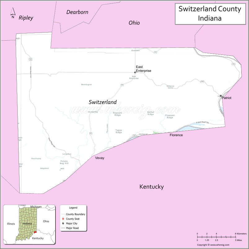
About Switzerland County Map, Alabama: The map showing the county boundary, county seat, major cities, highways, water bodies and neighbouring counties.
Related Indiana Maps
About Switzerland County, Indiana
Wabash County is a county located in the U.S. state of Indiana. It`s county seat is Wabash. As per 2020 census, the population of Wabash County was 30816 and population density of Wabash was square miles. According to the United States Census Bureau, the county has a total area of 412 sq mi (1,067 km2). Wabash County was established on Jan 30, 1833[19].
Switzerland County Facts
| Continent | North America |
| Country | United States |
| State | Indiana |
| County Seat | Vevay |
| Largest City/Town | Vevay |
| Established | 1814 |
| Total Area | 223 sq mi |
| Land Area | 220 sq mi |
| Water Area | 3.0 sq mi |
| Population | 10,613 (Census 2020) |
| Population Density | 48 people per sq mi |
| Time Zone | Eastern Time Zone (ET) |
| Major Highways | IN-56, IN-129, IN-156 |
| Neighboring Counties | Ripley County (north), Jefferson County (west), Gallatin County, KY (south), Carroll County, KY (east) |
| Famous For | Ohio River, Swiss heritage, wineries |
| Top Attractions | Swiss Wine Festival, Ohio River Scenic Byway, Vevay Riverfront |
| Official Website | https://switzerlandcounty.in.gov/ |
Cities and Towns in Switzerland County, Indiana
- Vevay (county seat) – 1,683 (Census 2020)
- Patriot – 209 (Census 2020)
Roads and Highways in Switzerland County, Indiana
Switzerland County is served by scenic highways that connect it to southeastern Indiana and Kentucky.
- Indiana State Road 56 – runs along the Ohio River connecting Vevay to Madison and Aurora
- Indiana State Road 129 – north-south route linking Vevay to Versailles and Batesville
- Indiana State Road 156 – connects the county to Patriot and Rising Sun
Neighboring Counties of Switzerland County
- Ripley County (north)
- Jefferson County (west)
- Gallatin County, Kentucky (south)
- Carroll County, Kentucky (east)
Top Attractions in Switzerland County, Indiana
Switzerland County offers scenic river views, historic sites, and cultural festivals.
- Swiss Wine Festival – annual celebration of the county’s Swiss heritage
- Ohio River Scenic Byway – picturesque drive along the river
- Vevay Riverfront – scenic area with views of the Ohio River
- Historic Vevay Downtown – charming streets with shops and historic buildings
- Belterra Casino Resort (nearby) – gaming and entertainment
- Wine trails and vineyards – local wineries reflecting Swiss traditions
Distance from Switzerland County to Nearby Cities
- Switzerland County to Cincinnati – 45 mi (72 km)
- Switzerland County to Louisville – 80 mi (129 km)
- Switzerland County to Indianapolis – 100 mi (161 km)
- Switzerland County to Lexington – 90 mi (145 km)
- Switzerland County to Dayton – 70 mi (113 km)
FAQs about Switzerland County
Switzerland County is located in southeastern Indiana along the Ohio River.
The county seat is Vevay, which is also the largest town in the county.
It is known for its Swiss heritage, wineries, and scenic river views.
Yes, it has a long history of winemaking dating back to early Swiss settlers.
The county is served by Indiana state roads including IN-56, IN-129, and IN-156.
- Adams County Map, IN
- Allen County Map, IN
- Bartholomew County Map, IN
- Benton County Map, IN
- Blackford County Map, IN
- Boone County Map, IN
- Brown County Map, IN
- Carroll County Map, IN
- Cass County Map, IN
- Clark County Map, IN
- Clay County Map, IN
- Clinton County Map, IN
- Crawford County Map, IN
- Daviess County Map, IN
- Dearborn County Map, IN
- Decatur County Map, IN
- DeKalb County Map, IN
- Delaware County Map, IN
- Dubois County Map, IN
- Elkhart County Map, IN
- Fayette County Map, IN
- Floyd County Map, IN
- Fountain County Map, IN
- Franklin County Map, IN
- Fulton County Map, IN
- Gibson County Map, IN
- Grant County Map, IN
- Greene County Map, IN
- Hamilton County Map, IN
- Hancock County Map, IN
- Harrison County Map, IN
- Hendricks County Map, IN
- Henry County Map, IN
- Howard County Map, IN
- Huntington County Map, IN
- Jackson County Map, IN
- Jasper County Map, IN
- Jay County Map, IN
- Jefferson County Map, IN
- Jennings County Map, IN
- Johnson County Map, IN
- Knox County Map, IN
- Kosciusko County Map, IN
- LaGrange County Map, IN
- Lake County Map, IN
- LaPorte County Map, IN
- Lawrence County Map, IN
- Madison County Map, IN
- Marion County Map, IN
- Marshall County Map, IN
- Martin County Map, IN
- Miami County Map, IN
- Monroe County Map, IN
- Montgomery County Map, IN
- Morgan County Map, IN
- Newton County Map, IN
- Noble County Map, IN
- Ohio County Map, IN
- Orange County Map, IN
- Owen County Map, IN
- Parke County Map, IN
- Perry County Map, IN
- Pike County Map, IN
- Porter County Map, IN
- Posey County Map, IN
- Pulaski County Map, IN
- Putnam County Map, IN
- Randolph County Map, IN
- Ripley County Map, IN
- Rush County Map, IN
- St Joseph County Map, IN
- Scott County Map, IN
- Shelby County Map, IN
- Spencer County Map, IN
- Starke County Map, IN
- Steuben County Map, IN
- Sullivan County Map, IN
- Switzerland County Map, IN
- Tippecanoe County Map, IN
- Tipton County Map, IN
- Union County Map, IN
- Vanderburgh County Map, IN
- Vermillion County Map, IN
- Vigo County Map, IN
- Wabash County Map, IN
- Warren County Map, IN
- Warrick County Map, IN
- Washington County Map, IN
- Wayne County Map, IN
- Wells County Map, IN
- White County Map, IN
- Whitley County Map, IN
- Alabama Counties
- Alaska boroughs
- Arizona Counties
- Arkansas Counties
- California County Map
- Colorado Counties
- Connecticut Counties
- Delaware Counties
- Florida County Map
- Georgia County Map
- Hawaii Counties
- Idaho Counties
- Illinois Counties
- Indiana Counties
- Iowa Counties
- Kansas Counties
- Kentucky Counties
- Louisiana Counties
- Maine Counties
- Maryland Counties
- Massachusetts Counties
- Michigan County Map
- Minnesota Counties
- Mississippi Counties
- Missouri Counties
- Montana Counties
- Nebraska Counties
- Nevada Counties
- New York Counties
- New Hampshire Counties
- New Jersey Counties
- New Mexico Counties
- North Carolina Counties
- North Dakota Counties
- Ohio County Map
- Oklahoma Counties
- Oregon Counties
- Pennsylvania Counties
- Rhode Island Counties
- South Carolina Counties
- South Dakota Counties
- Map of Tennessee
- Texas County Map
- Utah Counties
- Vermont Counties
- Virginia Counties
- Washington Counties
- West Virginia Counties
- Wisconsin Counties
- Wyoming Counties