By Whereig Editors, Reviewed by Mukesh Kumar| Updated On: May 02, 2026 | 20:16 ET
Map of Clinton County - Clinton County is a county located in the U.S. state of Indiana. Clinton County Map showing cities, highways, important places and water bodies. Get Where is Clinton County located in the map, major cities in Clinton county, population, areas, and places of interest.
Map of Clinton County, Indiana
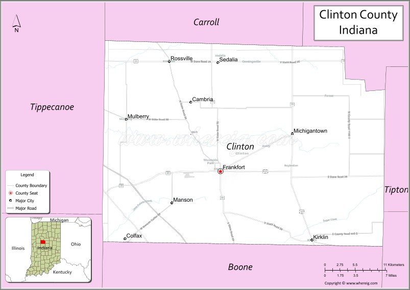
About Clinton County Map, Alabama: The map showing the county boundary, county seat, major cities, highways, water bodies and neighbouring counties.
Related Indiana Maps
About Clinton County, Indiana
Dubois County is a county located in the U.S. state of Indiana. It`s county seat is Jasper. As per 2020 census, the population of Dubois County was 43549 and population density of Dubois was square miles. According to the United States Census Bureau, the county has a total area of 427 sq mi (1,106 km2). Dubois County was established on -29960.
Clinton County Facts
| Continent | North America |
| Country | United States |
| State | Indiana |
| County Seat | Frankfort |
| Largest City/Town | Frankfort |
| Established | 1830 |
| Total Area | 405 sq mi |
| Land Area | 405 sq mi |
| Water Area | 0.5 sq mi |
| Population | 33,190 (Census 2020) |
| Population Density | 82 people per sq mi |
| Time Zone | Eastern Time Zone (ET) |
| Major Highways | I-65, US-421, IN-26, IN-28, IN-29, IN-39 |
| Neighboring Counties | Carroll County (north), Howard County (northeast), Tipton County (east), Hamilton County (southeast), Boone County (south), Montgomery County (west) |
| Famous For | Agriculture, Frankfort, rural communities |
| Top Attractions | Clinton County Courthouse, TPA Park, Frankfort Hot Dog Festival |
| Official Website | https://clintoncounty.in.gov/ |
Cities and Towns in Clinton County, Indiana
- Frankfort (county seat) – 16,693 (Census 2020)
- Mulberry – 1,260 (Census 2020)
- Rossville – 1,773 (Census 2020)
- Michigantown – 352 (Census 2020)
- Colfax – 691 (Census 2020)
- Kirklin – 764 (Census 2020)
Roads and Highways in Clinton County, Indiana
Clinton County is well connected by major highways, making travel easy between Lafayette, Indianapolis, and surrounding regions.
- Interstate 65 (I-65) – north-south route connecting Indianapolis to Chicago
- US Route 421 – runs north-south linking Frankfort to Michigan and southern Indiana
- Indiana State Road 26 – east-west highway connecting Lafayette to Kokomo
- Indiana State Road 28 – runs across northern Clinton County
- Indiana State Road 29 – connects Frankfort to Logansport and surrounding areas
- Indiana State Road 39 – north-south route linking Frankfort to Lebanon and Monticello
Neighboring Counties of Clinton County
- Carroll County (north)
- Howard County (northeast)
- Tipton County (east)
- Hamilton County (southeast)
- Boone County (south)
- Montgomery County (west)
Top Attractions in Clinton County, Indiana
Clinton County features small-town charm, community events, and parks that highlight local culture and history.
- Clinton County Courthouse – historic courthouse in Frankfort
- TPA Park – popular park with trails, sports, and community events
- Frankfort Hot Dog Festival – annual event celebrating local culture
- Gem City Park – family-friendly park with playgrounds and picnic areas
- Mulberry Centennial Park – small-town park with recreational spaces
- Rossville Downtown – quiet historic area with local shops
Distance from Clinton County to Nearby Cities
- Clinton County to Lafayette – 25 mi (40 km)
- Clinton County to Indianapolis – 50 mi (80 km)
- Clinton County to Kokomo – 30 mi (48 km)
- Clinton County to Chicago – 130 mi (209 km)
- Clinton County to Fort Wayne – 100 mi (161 km)
FAQs about Clinton County
Clinton County is located in central Indiana.
The county seat is Frankfort, which is also the largest city in the county.
It is known for agriculture, community events, and small-town living.
Yes, it is largely rural with farmland and small towns.
The county is served by I-65, US-421, and several Indiana state roads.
- Adams County Map, IN
- Allen County Map, IN
- Bartholomew County Map, IN
- Benton County Map, IN
- Blackford County Map, IN
- Boone County Map, IN
- Brown County Map, IN
- Carroll County Map, IN
- Cass County Map, IN
- Clark County Map, IN
- Clay County Map, IN
- Clinton County Map, IN
- Crawford County Map, IN
- Daviess County Map, IN
- Dearborn County Map, IN
- Decatur County Map, IN
- DeKalb County Map, IN
- Delaware County Map, IN
- Dubois County Map, IN
- Elkhart County Map, IN
- Fayette County Map, IN
- Floyd County Map, IN
- Fountain County Map, IN
- Franklin County Map, IN
- Fulton County Map, IN
- Gibson County Map, IN
- Grant County Map, IN
- Greene County Map, IN
- Hamilton County Map, IN
- Hancock County Map, IN
- Harrison County Map, IN
- Hendricks County Map, IN
- Henry County Map, IN
- Howard County Map, IN
- Huntington County Map, IN
- Jackson County Map, IN
- Jasper County Map, IN
- Jay County Map, IN
- Jefferson County Map, IN
- Jennings County Map, IN
- Johnson County Map, IN
- Knox County Map, IN
- Kosciusko County Map, IN
- LaGrange County Map, IN
- Lake County Map, IN
- LaPorte County Map, IN
- Lawrence County Map, IN
- Madison County Map, IN
- Marion County Map, IN
- Marshall County Map, IN
- Martin County Map, IN
- Miami County Map, IN
- Monroe County Map, IN
- Montgomery County Map, IN
- Morgan County Map, IN
- Newton County Map, IN
- Noble County Map, IN
- Ohio County Map, IN
- Orange County Map, IN
- Owen County Map, IN
- Parke County Map, IN
- Perry County Map, IN
- Pike County Map, IN
- Porter County Map, IN
- Posey County Map, IN
- Pulaski County Map, IN
- Putnam County Map, IN
- Randolph County Map, IN
- Ripley County Map, IN
- Rush County Map, IN
- St Joseph County Map, IN
- Scott County Map, IN
- Shelby County Map, IN
- Spencer County Map, IN
- Starke County Map, IN
- Steuben County Map, IN
- Sullivan County Map, IN
- Switzerland County Map, IN
- Tippecanoe County Map, IN
- Tipton County Map, IN
- Union County Map, IN
- Vanderburgh County Map, IN
- Vermillion County Map, IN
- Vigo County Map, IN
- Wabash County Map, IN
- Warren County Map, IN
- Warrick County Map, IN
- Washington County Map, IN
- Wayne County Map, IN
- Wells County Map, IN
- White County Map, IN
- Whitley County Map, IN
- Alabama Counties
- Alaska boroughs
- Arizona Counties
- Arkansas Counties
- California County Map
- Colorado Counties
- Connecticut Counties
- Delaware Counties
- Florida County Map
- Georgia County Map
- Hawaii Counties
- Idaho Counties
- Illinois Counties
- Indiana Counties
- Iowa Counties
- Kansas Counties
- Kentucky Counties
- Louisiana Counties
- Maine Counties
- Maryland Counties
- Massachusetts Counties
- Michigan County Map
- Minnesota Counties
- Mississippi Counties
- Missouri Counties
- Montana Counties
- Nebraska Counties
- Nevada Counties
- New York Counties
- New Hampshire Counties
- New Jersey Counties
- New Mexico Counties
- North Carolina Counties
- North Dakota Counties
- Ohio County Map
- Oklahoma Counties
- Oregon Counties
- Pennsylvania Counties
- Rhode Island Counties
- South Carolina Counties
- South Dakota Counties
- Map of Tennessee
- Texas County Map
- Utah Counties
- Vermont Counties
- Virginia Counties
- Washington Counties
- West Virginia Counties
- Wisconsin Counties
- Wyoming Counties