Boone County Map, Indianaa
Map of Boone County - Boone County is a county located in the U.S. state of Indiana. Boone County Map showing cities, highways, important places and water bodies. Get Where is Boone County located in the map, major cities in Boone county, population, areas, and places of interest.
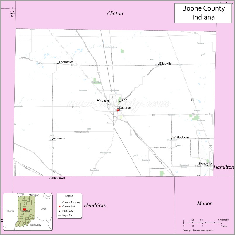
Map of Boone County, Indiana
About Boone County Map, Alabama: The map showing the county boundary, county seat, major cities, highways, water bodies and neighbouring counties.
Related Indiana Maps
About Boone County, Indiana
Crawford County is a county located in the U.S. state of Indiana. It`s county seat is English. As per 2020 census, the population of Crawford County was 10514 and population density of Crawford was square miles. According to the United States Census Bureau, the county has a total area of 306 sq mi (793 km2). Crawford County was established on -29920.
Boone County Facts
| Continent | North America |
| Country | United States |
| State | Indiana |
| County Seat | Lebanon |
| Largest City/Town | Lebanon |
| Established | 1830 |
| Total Area | 423 sq mi |
| Land Area | 423 sq mi |
| Water Area | 0.2 sq mi |
| Population | 70,543 (Census 2020) |
| Population Density | 167 people per sq mi |
| Time Zone | Eastern Time Zone (ET) |
| Major Highways | I-65, US-52, IN-32, IN-39, IN-47, IN-75 |
| Neighboring Counties | Clinton County (north), Hamilton County (east), Marion County (southeast), Hendricks County (south), Montgomery County (west) |
| Famous For | Rural landscapes, proximity to Indianapolis, growing communities |
| Top Attractions | Boone County Courthouse, Memorial Park, Golf courses |
| Official Website | https://www.boonecounty.in.gov/ |
Cities and Towns in Boone County, Indiana
- Lebanon (county seat) – 16,418 (Census 2020)
- Zionsville – 30,693 (Census 2020)
- Whitestown – 9,410 (Census 2020)
- Thorntown – 1,520 (Census 2020)
- Jamestown – 942 (Census 2020)
- Advance – 477 (Census 2020)
- Ulen – 117 (Census 2020)
Roads and Highways in Boone County, Indiana
Boone County is well connected by major highways, making it easy to travel to Indianapolis and surrounding regions.
- Interstate 65 (I-65) – north-south highway connecting Indianapolis to Chicago
- US Route 52 – runs northwest-southeast linking Lebanon to Lafayette and Indianapolis
- Indiana State Road 32 – east-west route connecting Zionsville to Crawfordsville
- Indiana State Road 39 – north-south highway through Lebanon
- Indiana State Road 47 – connects Thorntown to Sheridan and nearby areas
- Indiana State Road 75 – links Jamestown to Lafayette and Danville
Neighboring Counties of Boone County
- Clinton County (north)
- Hamilton County (east)
- Marion County (southeast)
- Hendricks County (south)
- Montgomery County (west)
Top Attractions in Boone County, Indiana
Boone County offers a mix of small-town charm, parks, and attractions close to the Indianapolis metro area.
- Boone County Courthouse – historic courthouse in downtown Lebanon
- Memorial Park – popular park with trails, sports facilities, and events
- Zionsville Village – charming downtown with shops and restaurants
- Golf Clubs – several well-known golf courses throughout the county
- Whitestown Parks – growing recreational areas with modern facilities
- Thorntown Heritage Museum – showcases local history
- Big 4 Rail Trail – scenic trail for walking and biking
Distance from Boone County to Nearby Cities
- Boone County to Indianapolis – 25 mi (40 km)
- Boone County to Lafayette – 45 mi (72 km)
- Boone County to Chicago – 140 mi (225 km)
- Boone County to Bloomington – 75 mi (121 km)
- Boone County to Terre Haute – 80 mi (129 km)
FAQs about Boone County
Boone County is located in central Indiana, just northwest of Indianapolis.
The county seat is Lebanon, which is also one of the largest cities in the county.
It is known for its growing communities, rural charm, and proximity to Indianapolis.
Yes, much of Boone County is considered part of the Indianapolis metropolitan area.
The county is served by I-65, US-52, and several Indiana state roads including IN-32 and IN-39.
- Adams County Map, IN
- Allen County Map, IN
- Bartholomew County Map, IN
- Benton County Map, IN
- Blackford County Map, IN
- Boone County Map, IN
- Brown County Map, IN
- Carroll County Map, IN
- Cass County Map, IN
- Clark County Map, IN
- Clay County Map, IN
- Clinton County Map, IN
- Crawford County Map, IN
- Daviess County Map, IN
- Dearborn County Map, IN
- Decatur County Map, IN
- DeKalb County Map, IN
- Delaware County Map, IN
- Dubois County Map, IN
- Elkhart County Map, IN
- Fayette County Map, IN
- Floyd County Map, IN
- Fountain County Map, IN
- Franklin County Map, IN
- Fulton County Map, IN
- Gibson County Map, IN
- Grant County Map, IN
- Greene County Map, IN
- Hamilton County Map, IN
- Hancock County Map, IN
- Harrison County Map, IN
- Hendricks County Map, IN
- Henry County Map, IN
- Howard County Map, IN
- Huntington County Map, IN
- Jackson County Map, IN
- Jasper County Map, IN
- Jay County Map, IN
- Jefferson County Map, IN
- Jennings County Map, IN
- Johnson County Map, IN
- Knox County Map, IN
- Kosciusko County Map, IN
- LaGrange County Map, IN
- Lake County Map, IN
- LaPorte County Map, IN
- Lawrence County Map, IN
- Madison County Map, IN
- Marion County Map, IN
- Marshall County Map, IN
- Martin County Map, IN
- Miami County Map, IN
- Monroe County Map, IN
- Montgomery County Map, IN
- Morgan County Map, IN
- Newton County Map, IN
- Noble County Map, IN
- Ohio County Map, IN
- Orange County Map, IN
- Owen County Map, IN
- Parke County Map, IN
- Perry County Map, IN
- Pike County Map, IN
- Porter County Map, IN
- Posey County Map, IN
- Pulaski County Map, IN
- Putnam County Map, IN
- Randolph County Map, IN
- Ripley County Map, IN
- Rush County Map, IN
- St Joseph County Map, IN
- Scott County Map, IN
- Shelby County Map, IN
- Spencer County Map, IN
- Starke County Map, IN
- Steuben County Map, IN
- Sullivan County Map, IN
- Switzerland County Map, IN
- Tippecanoe County Map, IN
- Tipton County Map, IN
- Union County Map, IN
- Vanderburgh County Map, IN
- Vermillion County Map, IN
- Vigo County Map, IN
- Wabash County Map, IN
- Warren County Map, IN
- Warrick County Map, IN
- Washington County Map, IN
- Wayne County Map, IN
- Wells County Map, IN
- White County Map, IN
- Whitley County Map, IN
- Alabama Counties
- Alaska boroughs
- Arizona Counties
- Arkansas Counties
- California County Map
- Colorado Counties
- Connecticut Counties
- Delaware Counties
- Florida County Map
- Georgia County Map
- Hawaii Counties
- Idaho Counties
- Illinois Counties
- Indiana Counties
- Iowa Counties
- Kansas Counties
- Kentucky Counties
- Louisiana Counties
- Maine Counties
- Maryland Counties
- Massachusetts Counties
- Michigan County Map
- Minnesota Counties
- Mississippi Counties
- Missouri Counties
- Montana Counties
- Nebraska Counties
- Nevada Counties
- New York Counties
- New Hampshire Counties
- New Jersey Counties
- New Mexico Counties
- North Carolina Counties
- North Dakota Counties
- Ohio County Map
- Oklahoma Counties
- Oregon Counties
- Pennsylvania Counties
- Rhode Island Counties
- South Carolina Counties
- South Dakota Counties
- Map of Tennessee
- Texas County Map
- Utah Counties
- Vermont Counties
- Virginia Counties
- Washington Counties
- West Virginia Counties
- Wisconsin Counties
- Wyoming Counties