By Whereig Editors, Reviewed by Mukesh Kumar| Updated On: May 02, 2026 | 20:16 ET
Map of Scott County - Scott County is a county located in the U.S. state of Indiana. Scott County Map showing cities, highways, important places and water bodies. Get Where is Scott County located in the map, major cities in Scott county, population, areas, and places of interest.
Map of Scott County, Indiana
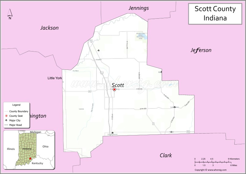
About Scott County Map, Alabama: The map showing the county boundary, county seat, major cities, highways, water bodies and neighbouring counties.
Related Indiana Maps
About Scott County, Indiana
Tippecanoe County is a county located in the U.S. state of Indiana. It`s county seat is Lafayette. As per 2020 census, the population of Tippecanoe County was 187076 and population density of Tippecanoe was square miles. According to the United States Census Bureau, the county has a total area of 500 sq mi (1,295 km2). Tippecanoe County was established on -27007.
Scott County Facts
| Continent | North America |
| Country | United States |
| State | Indiana |
| County Seat | Scottsburg |
| Largest City/Town | Scottsburg |
| Established | 1820 |
| Total Area | 192 sq mi |
| Land Area | 190 sq mi |
| Water Area | 2.3 sq mi |
| Population | 24,181 (Census 2020) |
| Population Density | 127 people per sq mi |
| Time Zone | Eastern Time Zone (ET) |
| Major Highways | I-65, US-31, IN-3, IN-56, IN-362 |
| Neighboring Counties | Jackson County (north), Jefferson County (east), Clark County (south), Washington County (west) |
| Famous For | Scottsburg, Hardy Lake, rural landscapes |
| Top Attractions | Hardy Lake, Scott County Heritage Center & Museum, Scott County Fairgrounds |
| Official Website | https://scottcounty.in.gov/ |
Cities and Towns in Scott County, Indiana
- Scottsburg (county seat) – 7,345 (Census 2020)
- Austin – 4,254 (Census 2020)
- Lexington – 2,148 (Census 2020)
- Deputy – 110 (Census 2020)
Roads and Highways in Scott County, Indiana
Scott County is served by major highways that connect it to southern Indiana and nearby metropolitan areas.
- Interstate 65 (I-65) – north-south route connecting Scottsburg to Indianapolis and Louisville
- US Route 31 – runs parallel to I-65 linking Scottsburg to Seymour and Jeffersonville
- Indiana State Road 3 – north-south route connecting the county to North Vernon and Charlestown
- Indiana State Road 56 – east-west highway linking Scottsburg to Salem and Madison
- Indiana State Road 362 – connects the county to Austin and surrounding communities
Neighboring Counties of Scott County
- Jackson County (north)
- Jefferson County (east)
- Clark County (south)
- Washington County (west)
Top Attractions in Scott County, Indiana
Scott County offers parks, lakes, and local history attractions.
- Hardy Lake – popular destination for boating, fishing, and camping
- Scott County Heritage Center & Museum – exhibits on local history and culture
- Scott County Fairgrounds – hosts annual fairs and events
- Austin Downtown – small-town charm with local shops
- Linza Graham Park – recreational park with trails and facilities
- Scottsburg Downtown – historic area with shops and dining
Distance from Scott County to Nearby Cities
- Scott County to Louisville – 30 mi (48 km)
- Scott County to Indianapolis – 85 mi (137 km)
- Scott County to Cincinnati – 100 mi (161 km)
- Scott County to Lexington – 110 mi (177 km)
- Scott County to Evansville – 140 mi (225 km)
FAQs about Scott County
Scott County is located in southern Indiana.
The county seat is Scottsburg, which is also the largest city in the county.
It is known for Hardy Lake, rural landscapes, and small-town communities.
Yes, it is part of the Louisville metropolitan area.
The county is served by I-65, US-31, and several Indiana state roads.
- Adams County Map, IN
- Allen County Map, IN
- Bartholomew County Map, IN
- Benton County Map, IN
- Blackford County Map, IN
- Boone County Map, IN
- Brown County Map, IN
- Carroll County Map, IN
- Cass County Map, IN
- Clark County Map, IN
- Clay County Map, IN
- Clinton County Map, IN
- Crawford County Map, IN
- Daviess County Map, IN
- Dearborn County Map, IN
- Decatur County Map, IN
- DeKalb County Map, IN
- Delaware County Map, IN
- Dubois County Map, IN
- Elkhart County Map, IN
- Fayette County Map, IN
- Floyd County Map, IN
- Fountain County Map, IN
- Franklin County Map, IN
- Fulton County Map, IN
- Gibson County Map, IN
- Grant County Map, IN
- Greene County Map, IN
- Hamilton County Map, IN
- Hancock County Map, IN
- Harrison County Map, IN
- Hendricks County Map, IN
- Henry County Map, IN
- Howard County Map, IN
- Huntington County Map, IN
- Jackson County Map, IN
- Jasper County Map, IN
- Jay County Map, IN
- Jefferson County Map, IN
- Jennings County Map, IN
- Johnson County Map, IN
- Knox County Map, IN
- Kosciusko County Map, IN
- LaGrange County Map, IN
- Lake County Map, IN
- LaPorte County Map, IN
- Lawrence County Map, IN
- Madison County Map, IN
- Marion County Map, IN
- Marshall County Map, IN
- Martin County Map, IN
- Miami County Map, IN
- Monroe County Map, IN
- Montgomery County Map, IN
- Morgan County Map, IN
- Newton County Map, IN
- Noble County Map, IN
- Ohio County Map, IN
- Orange County Map, IN
- Owen County Map, IN
- Parke County Map, IN
- Perry County Map, IN
- Pike County Map, IN
- Porter County Map, IN
- Posey County Map, IN
- Pulaski County Map, IN
- Putnam County Map, IN
- Randolph County Map, IN
- Ripley County Map, IN
- Rush County Map, IN
- St Joseph County Map, IN
- Scott County Map, IN
- Shelby County Map, IN
- Spencer County Map, IN
- Starke County Map, IN
- Steuben County Map, IN
- Sullivan County Map, IN
- Switzerland County Map, IN
- Tippecanoe County Map, IN
- Tipton County Map, IN
- Union County Map, IN
- Vanderburgh County Map, IN
- Vermillion County Map, IN
- Vigo County Map, IN
- Wabash County Map, IN
- Warren County Map, IN
- Warrick County Map, IN
- Washington County Map, IN
- Wayne County Map, IN
- Wells County Map, IN
- White County Map, IN
- Whitley County Map, IN
- Alabama Counties
- Alaska boroughs
- Arizona Counties
- Arkansas Counties
- California County Map
- Colorado Counties
- Connecticut Counties
- Delaware Counties
- Florida County Map
- Georgia County Map
- Hawaii Counties
- Idaho Counties
- Illinois Counties
- Indiana Counties
- Iowa Counties
- Kansas Counties
- Kentucky Counties
- Louisiana Counties
- Maine Counties
- Maryland Counties
- Massachusetts Counties
- Michigan County Map
- Minnesota Counties
- Mississippi Counties
- Missouri Counties
- Montana Counties
- Nebraska Counties
- Nevada Counties
- New York Counties
- New Hampshire Counties
- New Jersey Counties
- New Mexico Counties
- North Carolina Counties
- North Dakota Counties
- Ohio County Map
- Oklahoma Counties
- Oregon Counties
- Pennsylvania Counties
- Rhode Island Counties
- South Carolina Counties
- South Dakota Counties
- Map of Tennessee
- Texas County Map
- Utah Counties
- Vermont Counties
- Virginia Counties
- Washington Counties
- West Virginia Counties
- Wisconsin Counties
- Wyoming Counties