By Whereig Editors, Reviewed by Mukesh Kumar| Updated On: May 02, 2026 | 20:16 ET
Map of Delaware County - Delaware County is a county located in the U.S. state of Indiana. Delaware County Map showing cities, highways, important places and water bodies. Get Where is Delaware County located in the map, major cities in Delaware county, population, areas, and places of interest.
Map of Delaware County, Indiana
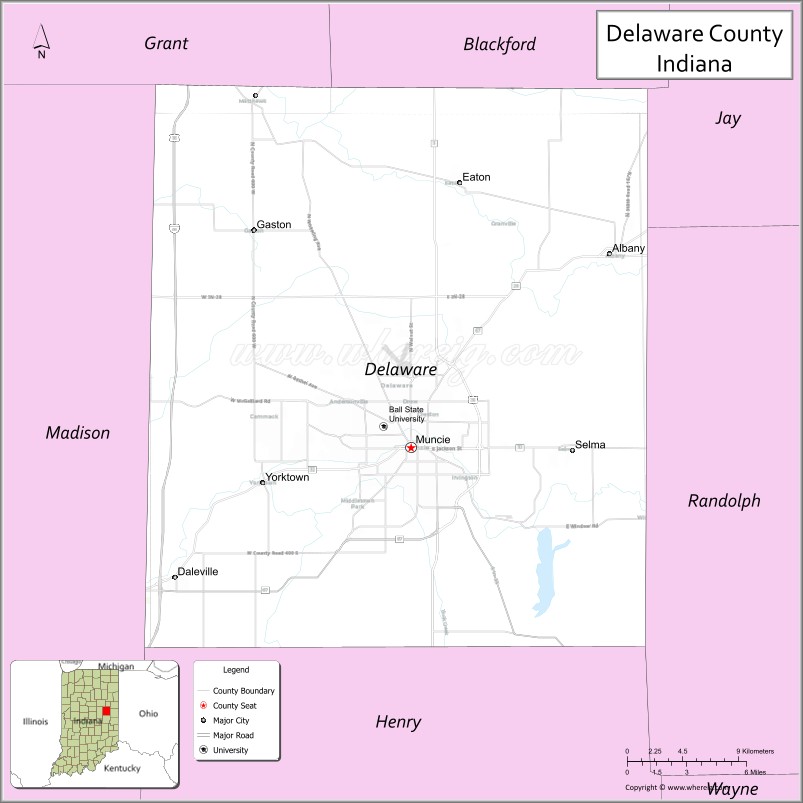
About Delaware County Map, Alabama: The map showing the county boundary, county seat, major cities, highways, water bodies and neighbouring counties.
Related Indiana Maps
About Delaware County, Indiana
Fulton County is a county located in the U.S. state of Indiana. It`s county seat is Rochester. As per 2020 census, the population of Fulton County was 20386 and population density of Fulton was square miles. According to the United States Census Bureau, the county has a total area of 368 sq mi (953 km2). Fulton County was established on -23337.
Delaware County Facts
| Continent | North America |
| Country | United States |
| State | Indiana |
| County Seat | Muncie |
| Largest City/Town | Muncie |
| Established | 1827 |
| Total Area | 395 sq mi |
| Land Area | 393 sq mi |
| Water Area | 2.2 sq mi |
| Population | 111,903 (Census 2020) |
| Population Density | 285 people per sq mi |
| Time Zone | Eastern Time Zone (ET) |
| Major Highways | US-35, IN-3, IN-32, IN-67 |
| Neighboring Counties | Grant County (north), Blackford County (northeast), Jay County (east), Randolph County (east), Henry County (south), Madison County (west) |
| Famous For | Ball State University, Muncie, glass industry history |
| Top Attractions | Ball State University, Minnetrista, Prairie Creek Reservoir |
| Official Website | https://www.co.delaware.in.us/ |
Cities and Towns in Delaware County, Indiana
- Muncie (county seat) – 65,194 (Census 2020)
- Yorktown – 11,784 (Census 2020)
- Albany – 2,165 (Census 2020)
- Daleville – 1,651 (Census 2020)
- Eaton – 1,477 (Census 2020)
- Gaston – 871 (Census 2020)
- Selma – 747 (Census 2020)
Roads and Highways in Delaware County, Indiana
Delaware County has a solid highway network that supports travel across east-central Indiana and connects to major regional cities.
- US Route 35 – runs northwest-southeast connecting Muncie to Richmond and Kokomo
- Indiana State Road 3 – north-south route linking Muncie to Fort Wayne and New Castle
- Indiana State Road 32 – east-west highway connecting Muncie to Anderson and Winchester
- Indiana State Road 67 – runs southwest-northeast linking Muncie to Indianapolis
Neighboring Counties of Delaware County
- Grant County (north)
- Blackford County (northeast)
- Jay County (east)
- Randolph County (east)
- Henry County (south)
- Madison County (west)
Top Attractions in Delaware County, Indiana
Delaware County offers a mix of education, culture, and outdoor recreation centered around the city of Muncie.
- Ball State University – major public university with beautiful campus
- Minnetrista – cultural center with gardens, exhibits, and events
- Prairie Creek Reservoir – popular spot for boating, fishing, and camping
- David Owsley Museum of Art – art museum located at Ball State University
- Muncie Children's Museum – interactive exhibits for families
- Cardinal Greenway – scenic trail for biking and walking
- Downtown Muncie – historic area with shops and dining
Distance from Delaware County to Nearby Cities
- Delaware County to Indianapolis – 60 mi (97 km)
- Delaware County to Fort Wayne – 70 mi (113 km)
- Delaware County to Dayton – 100 mi (161 km)
- Delaware County to Cincinnati – 110 mi (177 km)
- Delaware County to Chicago – 160 mi (257 km)
FAQs about Delaware County
Delaware County is located in east-central Indiana.
The county seat is Muncie, which is also the largest city in the county.
It is known for Ball State University, Muncie, and its history in the glass industry.
It has a mix of urban areas like Muncie and surrounding rural communities.
The county is served by US-35 and several Indiana state roads including IN-3, IN-32, and IN-67.
- Adams County Map, IN
- Allen County Map, IN
- Bartholomew County Map, IN
- Benton County Map, IN
- Blackford County Map, IN
- Boone County Map, IN
- Brown County Map, IN
- Carroll County Map, IN
- Cass County Map, IN
- Clark County Map, IN
- Clay County Map, IN
- Clinton County Map, IN
- Crawford County Map, IN
- Daviess County Map, IN
- Dearborn County Map, IN
- Decatur County Map, IN
- DeKalb County Map, IN
- Delaware County Map, IN
- Dubois County Map, IN
- Elkhart County Map, IN
- Fayette County Map, IN
- Floyd County Map, IN
- Fountain County Map, IN
- Franklin County Map, IN
- Fulton County Map, IN
- Gibson County Map, IN
- Grant County Map, IN
- Greene County Map, IN
- Hamilton County Map, IN
- Hancock County Map, IN
- Harrison County Map, IN
- Hendricks County Map, IN
- Henry County Map, IN
- Howard County Map, IN
- Huntington County Map, IN
- Jackson County Map, IN
- Jasper County Map, IN
- Jay County Map, IN
- Jefferson County Map, IN
- Jennings County Map, IN
- Johnson County Map, IN
- Knox County Map, IN
- Kosciusko County Map, IN
- LaGrange County Map, IN
- Lake County Map, IN
- LaPorte County Map, IN
- Lawrence County Map, IN
- Madison County Map, IN
- Marion County Map, IN
- Marshall County Map, IN
- Martin County Map, IN
- Miami County Map, IN
- Monroe County Map, IN
- Montgomery County Map, IN
- Morgan County Map, IN
- Newton County Map, IN
- Noble County Map, IN
- Ohio County Map, IN
- Orange County Map, IN
- Owen County Map, IN
- Parke County Map, IN
- Perry County Map, IN
- Pike County Map, IN
- Porter County Map, IN
- Posey County Map, IN
- Pulaski County Map, IN
- Putnam County Map, IN
- Randolph County Map, IN
- Ripley County Map, IN
- Rush County Map, IN
- St Joseph County Map, IN
- Scott County Map, IN
- Shelby County Map, IN
- Spencer County Map, IN
- Starke County Map, IN
- Steuben County Map, IN
- Sullivan County Map, IN
- Switzerland County Map, IN
- Tippecanoe County Map, IN
- Tipton County Map, IN
- Union County Map, IN
- Vanderburgh County Map, IN
- Vermillion County Map, IN
- Vigo County Map, IN
- Wabash County Map, IN
- Warren County Map, IN
- Warrick County Map, IN
- Washington County Map, IN
- Wayne County Map, IN
- Wells County Map, IN
- White County Map, IN
- Whitley County Map, IN
- Alabama Counties
- Alaska boroughs
- Arizona Counties
- Arkansas Counties
- California County Map
- Colorado Counties
- Connecticut Counties
- Delaware Counties
- Florida County Map
- Georgia County Map
- Hawaii Counties
- Idaho Counties
- Illinois Counties
- Indiana Counties
- Iowa Counties
- Kansas Counties
- Kentucky Counties
- Louisiana Counties
- Maine Counties
- Maryland Counties
- Massachusetts Counties
- Michigan County Map
- Minnesota Counties
- Mississippi Counties
- Missouri Counties
- Montana Counties
- Nebraska Counties
- Nevada Counties
- New York Counties
- New Hampshire Counties
- New Jersey Counties
- New Mexico Counties
- North Carolina Counties
- North Dakota Counties
- Ohio County Map
- Oklahoma Counties
- Oregon Counties
- Pennsylvania Counties
- Rhode Island Counties
- South Carolina Counties
- South Dakota Counties
- Map of Tennessee
- Texas County Map
- Utah Counties
- Vermont Counties
- Virginia Counties
- Washington Counties
- West Virginia Counties
- Wisconsin Counties
- Wyoming Counties