By Whereig Editors, Reviewed by Mukesh Kumar| Updated On: May 02, 2026 | 20:16 ET
Map of Benton County - Benton County is a county located in the U.S. state of Indiana. Benton County Map showing cities, highways, important places and water bodies. Get Where is Benton County located in the map, major cities in Benton county, population, areas, and places of interest.
Map of Benton County, Indiana
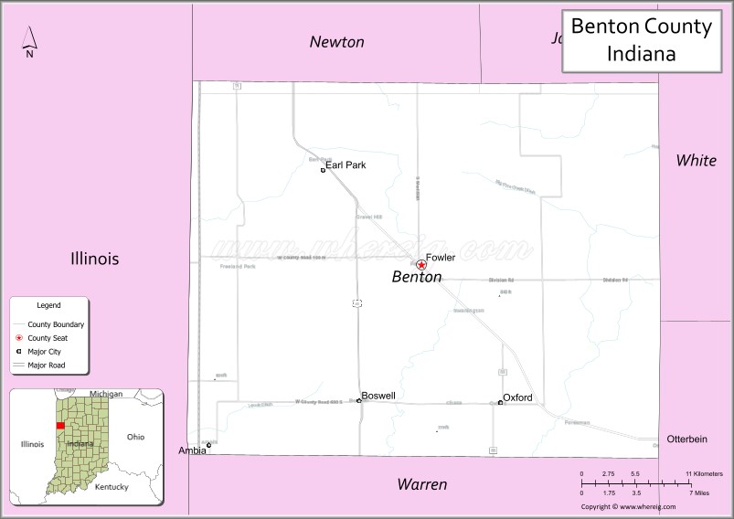
About Benton County Map, Alabama: The map showing the county boundary, county seat, major cities, highways, water bodies and neighbouring counties.
Related Indiana Maps
About Benton County, Indiana
Clay County is a county located in the U.S. state of Indiana. It`s county seat is Brazil. As per 2020 census, the population of Clay County was 26410 and population density of Clay was square miles. According to the United States Census Bureau, the county has a total area of 358 sq mi (927 km2). Clay County was established on -27349.
Benton County Facts
| Continent | North America |
| Country | United States |
| State | Indiana |
| County Seat | Fowler |
| Largest City/Town | Fowler |
| Established | 1840 |
| Total Area | 406 sq mi |
| Land Area | 406 sq mi |
| Water Area | 0.1 sq mi |
| Population | 8,719 (Census 2020) |
| Population Density | 21 people per sq mi |
| Time Zone | Eastern Time Zone (ET) |
| Major Highways | US-41, US-52, IN-18, IN-55, IN-352 |
| Neighboring Counties | Jasper County (north), White County (east), Tippecanoe County (southeast), Warren County (south), Newton County (west) |
| Famous For | Agriculture, wind farms, rural landscapes |
| Top Attractions | Benton County Courthouse, wind turbines, local parks |
| Official Website | https://bentoncounty.in.gov/ |
Cities and Towns in Benton County, Indiana
- Fowler (county seat) – 2,308 (Census 2020)
- Ambia – 196 (Census 2020)
- Oxford – 1,123 (Census 2020)
- Earl Park – 385 (Census 2020)
- Boswell – 778 (Census 2020)
Roads and Highways in Benton County, Indiana
Benton County is served by several key highways that support agricultural transport and connect the area to nearby counties and Illinois.
- US Route 41 – north-south highway connecting the county to Lake Michigan and southern Indiana
- US Route 52 – runs northwest-southeast linking the county to Illinois and Lafayette
- Indiana State Road 18 – east-west route across northern Indiana
- Indiana State Road 55 – connects Benton County to Gary and central Indiana
- Indiana State Road 352 – links Boswell to surrounding rural areas
Neighboring Counties of Benton County
- Jasper County (north)
- White County (east)
- Tippecanoe County (southeast)
- Warren County (south)
- Newton County (west)
Top Attractions in Benton County, Indiana
Benton County offers quiet rural scenery, historic sites, and unique wind energy landscapes.
- Benton County Courthouse – historic courthouse in Fowler
- Wind Farms – large fields of wind turbines across the county
- Oxford Town Square – small-town charm with local shops
- Local Parks – peaceful parks for picnics and outdoor activities
- Historic Churches – early structures reflecting local heritage
- Agricultural Landscapes – scenic drives through farmland
Distance from Benton County to Nearby Cities
- Benton County to Lafayette – 30 mi (48 km)
- Benton County to Indianapolis – 90 mi (145 km)
- Benton County to Chicago – 110 mi (177 km)
- Benton County to Champaign – 70 mi (113 km)
- Benton County to Gary – 95 mi (153 km)
FAQs about Benton County
Benton County is located in northwestern Indiana near the Illinois border.
The county seat is Fowler, which is also the largest town.
It is known for agriculture, wind farms, and wide rural landscapes.
Yes, it is largely rural with a strong farming economy.
The main highways include US-41, US-52, and several Indiana state roads.
- Adams County Map, IN
- Allen County Map, IN
- Bartholomew County Map, IN
- Benton County Map, IN
- Blackford County Map, IN
- Boone County Map, IN
- Brown County Map, IN
- Carroll County Map, IN
- Cass County Map, IN
- Clark County Map, IN
- Clay County Map, IN
- Clinton County Map, IN
- Crawford County Map, IN
- Daviess County Map, IN
- Dearborn County Map, IN
- Decatur County Map, IN
- DeKalb County Map, IN
- Delaware County Map, IN
- Dubois County Map, IN
- Elkhart County Map, IN
- Fayette County Map, IN
- Floyd County Map, IN
- Fountain County Map, IN
- Franklin County Map, IN
- Fulton County Map, IN
- Gibson County Map, IN
- Grant County Map, IN
- Greene County Map, IN
- Hamilton County Map, IN
- Hancock County Map, IN
- Harrison County Map, IN
- Hendricks County Map, IN
- Henry County Map, IN
- Howard County Map, IN
- Huntington County Map, IN
- Jackson County Map, IN
- Jasper County Map, IN
- Jay County Map, IN
- Jefferson County Map, IN
- Jennings County Map, IN
- Johnson County Map, IN
- Knox County Map, IN
- Kosciusko County Map, IN
- LaGrange County Map, IN
- Lake County Map, IN
- LaPorte County Map, IN
- Lawrence County Map, IN
- Madison County Map, IN
- Marion County Map, IN
- Marshall County Map, IN
- Martin County Map, IN
- Miami County Map, IN
- Monroe County Map, IN
- Montgomery County Map, IN
- Morgan County Map, IN
- Newton County Map, IN
- Noble County Map, IN
- Ohio County Map, IN
- Orange County Map, IN
- Owen County Map, IN
- Parke County Map, IN
- Perry County Map, IN
- Pike County Map, IN
- Porter County Map, IN
- Posey County Map, IN
- Pulaski County Map, IN
- Putnam County Map, IN
- Randolph County Map, IN
- Ripley County Map, IN
- Rush County Map, IN
- St Joseph County Map, IN
- Scott County Map, IN
- Shelby County Map, IN
- Spencer County Map, IN
- Starke County Map, IN
- Steuben County Map, IN
- Sullivan County Map, IN
- Switzerland County Map, IN
- Tippecanoe County Map, IN
- Tipton County Map, IN
- Union County Map, IN
- Vanderburgh County Map, IN
- Vermillion County Map, IN
- Vigo County Map, IN
- Wabash County Map, IN
- Warren County Map, IN
- Warrick County Map, IN
- Washington County Map, IN
- Wayne County Map, IN
- Wells County Map, IN
- White County Map, IN
- Whitley County Map, IN
- Alabama Counties
- Alaska boroughs
- Arizona Counties
- Arkansas Counties
- California County Map
- Colorado Counties
- Connecticut Counties
- Delaware Counties
- Florida County Map
- Georgia County Map
- Hawaii Counties
- Idaho Counties
- Illinois Counties
- Indiana Counties
- Iowa Counties
- Kansas Counties
- Kentucky Counties
- Louisiana Counties
- Maine Counties
- Maryland Counties
- Massachusetts Counties
- Michigan County Map
- Minnesota Counties
- Mississippi Counties
- Missouri Counties
- Montana Counties
- Nebraska Counties
- Nevada Counties
- New York Counties
- New Hampshire Counties
- New Jersey Counties
- New Mexico Counties
- North Carolina Counties
- North Dakota Counties
- Ohio County Map
- Oklahoma Counties
- Oregon Counties
- Pennsylvania Counties
- Rhode Island Counties
- South Carolina Counties
- South Dakota Counties
- Map of Tennessee
- Texas County Map
- Utah Counties
- Vermont Counties
- Virginia Counties
- Washington Counties
- West Virginia Counties
- Wisconsin Counties
- Wyoming Counties