By Whereig Editors, Reviewed by Mukesh Kumar| Updated On: May 02, 2026 | 20:16 ET
Map of LaPorte County - LaPorte County is a county located in the U.S. state of Indiana. LaPorte County Map showing cities, highways, important places and water bodies. Get Where is LaPorte County located in the map, major cities in LaPorte county, population, areas, and places of interest.
Map of LaPorte County, Indiana
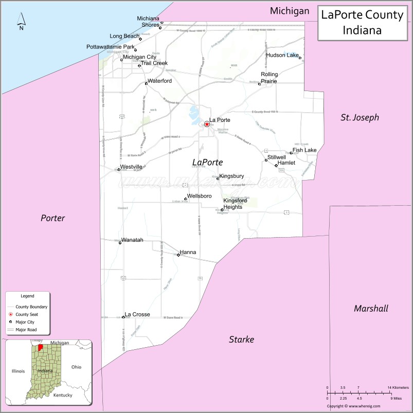
About LaPorte County Map, Alabama: The map showing the county boundary, county seat, major cities, highways, water bodies and neighbouring counties.
Related Indiana Maps
About LaPorte County, Indiana
Monroe County is a county located in the U.S. state of Indiana. It`s county seat is Bloomington. As per 2020 census, the population of Monroe County was 139875 and population density of Monroe was square miles. According to the United States Census Bureau, the county has a total area of 395 sq mi (1,023 km2). Monroe County was established on -29935.
LaPorte County Facts
| Continent | North America |
| Country | United States |
| State | Indiana |
| County Seat | La Porte |
| Largest City/Town | Michigan City |
| Established | 1832 |
| Total Area | 613 sq mi |
| Land Area | 598 sq mi |
| Water Area | 15 sq mi |
| Population | 111,467 (Census 2020) |
| Population Density | 186 people per sq mi |
| Time Zone | Central Time Zone (CT) |
| Major Highways | I-80, I-90, I-94, US-12, US-20, US-35, IN-2, IN-39 |
| Neighboring Counties | Berrien County, MI (north), St. Joseph County (east), Starke County (south), Porter County (west) |
| Famous For | Indiana Dunes, Lake Michigan shoreline, Michigan City |
| Top Attractions | Indiana Dunes National Park, Washington Park, Lighthouse Place Premium Outlets |
| Official Website | https://www.laportecounty.org/ |
Cities and Towns in LaPorte County, Indiana
- Michigan City – 32,075 (Census 2020)
- La Porte (county seat) – 22,053 (Census 2020)
- Westville – 5,252 (Census 2020)
- Trail Creek – 2,052 (Census 2020)
- Kingsford Heights – 1,435 (Census 2020)
- Long Beach – 1,123 (Census 2020)
- Pottawattamie Park – 224 (Census 2020)
Roads and Highways in LaPorte County, Indiana
LaPorte County has a strong transportation network with major highways connecting it to Chicago and northern Indiana.
- Interstate 80/90 (I-80/I-90) – Indiana Toll Road linking the county to Chicago and Ohio
- Interstate 94 (I-94) – east-west route connecting Michigan City to Chicago and Detroit
- US Route 12 – runs along Lake Michigan connecting coastal communities
- US Route 20 – major east-west highway linking Michigan City to South Bend and Chicago
- US Route 35 – connects La Porte to Logansport and Kokomo
- Indiana State Road 2 – links La Porte to Valparaiso and South Bend
- Indiana State Road 39 – north-south route connecting La Porte to Monticello
Neighboring Counties of LaPorte County
- Berrien County, Michigan (north)
- St. Joseph County (east)
- Starke County (south)
- Porter County (west)
Top Attractions in LaPorte County, Indiana
LaPorte County offers beaches, parks, and vibrant lakefront attractions along Lake Michigan.
- Indiana Dunes National Park – scenic dunes, beaches, and hiking trails
- Washington Park – lakefront park with a beach and marina in Michigan City
- Lighthouse Place Premium Outlets – popular shopping destination
- Michigan City Lighthouse – historic lighthouse along the shoreline
- Pine Lake – scenic lake in La Porte with recreational activities
- Friendship Botanic Gardens – peaceful gardens with walking paths
Distance from LaPorte County to Nearby Cities
- LaPorte County to Chicago – 60 mi (97 km)
- LaPorte County to South Bend – 35 mi (56 km)
- LaPorte County to Indianapolis – 140 mi (225 km)
- LaPorte County to Detroit – 230 mi (370 km)
- LaPorte County to Milwaukee – 140 mi (225 km)
FAQs about LaPorte County
LaPorte County is located in northwestern Indiana along Lake Michigan.
The county seat is La Porte, while Michigan City is the largest city.
It is known for Lake Michigan beaches, Indiana Dunes, and Michigan City attractions.
Yes, it attracts visitors for its beaches, parks, and lakefront activities.
The county is served by I-80, I-90, I-94, and several U.S. and Indiana state highways.
- Adams County Map, IN
- Allen County Map, IN
- Bartholomew County Map, IN
- Benton County Map, IN
- Blackford County Map, IN
- Boone County Map, IN
- Brown County Map, IN
- Carroll County Map, IN
- Cass County Map, IN
- Clark County Map, IN
- Clay County Map, IN
- Clinton County Map, IN
- Crawford County Map, IN
- Daviess County Map, IN
- Dearborn County Map, IN
- Decatur County Map, IN
- DeKalb County Map, IN
- Delaware County Map, IN
- Dubois County Map, IN
- Elkhart County Map, IN
- Fayette County Map, IN
- Floyd County Map, IN
- Fountain County Map, IN
- Franklin County Map, IN
- Fulton County Map, IN
- Gibson County Map, IN
- Grant County Map, IN
- Greene County Map, IN
- Hamilton County Map, IN
- Hancock County Map, IN
- Harrison County Map, IN
- Hendricks County Map, IN
- Henry County Map, IN
- Howard County Map, IN
- Huntington County Map, IN
- Jackson County Map, IN
- Jasper County Map, IN
- Jay County Map, IN
- Jefferson County Map, IN
- Jennings County Map, IN
- Johnson County Map, IN
- Knox County Map, IN
- Kosciusko County Map, IN
- LaGrange County Map, IN
- Lake County Map, IN
- LaPorte County Map, IN
- Lawrence County Map, IN
- Madison County Map, IN
- Marion County Map, IN
- Marshall County Map, IN
- Martin County Map, IN
- Miami County Map, IN
- Monroe County Map, IN
- Montgomery County Map, IN
- Morgan County Map, IN
- Newton County Map, IN
- Noble County Map, IN
- Ohio County Map, IN
- Orange County Map, IN
- Owen County Map, IN
- Parke County Map, IN
- Perry County Map, IN
- Pike County Map, IN
- Porter County Map, IN
- Posey County Map, IN
- Pulaski County Map, IN
- Putnam County Map, IN
- Randolph County Map, IN
- Ripley County Map, IN
- Rush County Map, IN
- St Joseph County Map, IN
- Scott County Map, IN
- Shelby County Map, IN
- Spencer County Map, IN
- Starke County Map, IN
- Steuben County Map, IN
- Sullivan County Map, IN
- Switzerland County Map, IN
- Tippecanoe County Map, IN
- Tipton County Map, IN
- Union County Map, IN
- Vanderburgh County Map, IN
- Vermillion County Map, IN
- Vigo County Map, IN
- Wabash County Map, IN
- Warren County Map, IN
- Warrick County Map, IN
- Washington County Map, IN
- Wayne County Map, IN
- Wells County Map, IN
- White County Map, IN
- Whitley County Map, IN
- Alabama Counties
- Alaska boroughs
- Arizona Counties
- Arkansas Counties
- California County Map
- Colorado Counties
- Connecticut Counties
- Delaware Counties
- Florida County Map
- Georgia County Map
- Hawaii Counties
- Idaho Counties
- Illinois Counties
- Indiana Counties
- Iowa Counties
- Kansas Counties
- Kentucky Counties
- Louisiana Counties
- Maine Counties
- Maryland Counties
- Massachusetts Counties
- Michigan County Map
- Minnesota Counties
- Mississippi Counties
- Missouri Counties
- Montana Counties
- Nebraska Counties
- Nevada Counties
- New York Counties
- New Hampshire Counties
- New Jersey Counties
- New Mexico Counties
- North Carolina Counties
- North Dakota Counties
- Ohio County Map
- Oklahoma Counties
- Oregon Counties
- Pennsylvania Counties
- Rhode Island Counties
- South Carolina Counties
- South Dakota Counties
- Map of Tennessee
- Texas County Map
- Utah Counties
- Vermont Counties
- Virginia Counties
- Washington Counties
- West Virginia Counties
- Wisconsin Counties
- Wyoming Counties