By Whereig Editors, Reviewed by Mukesh Kumar| Updated On: May 02, 2026 | 20:16 ET
Map of Adams County - Adams County is a county located in the U.S. state of Indiana. Adams County Map showing cities, highways, important places and water bodies. Get Where is Adams County located in the map, major cities in Adams county, population, areas, and places of interest.
Map of Adams County, Indiana
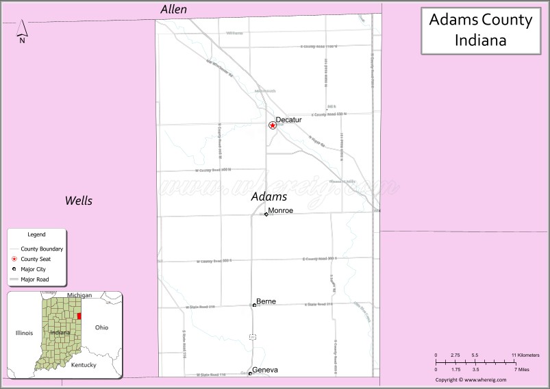
About Adams County Map, Alabama: The map showing the county boundary, county seat, major cities, highways, water bodies and neighbouring counties.
Related Indiana Maps
About Adams County, Indiana
Carroll County is a county located in the U.S. state of Indiana. It`s county seat is Delphi. As per 2020 census, the population of Carroll County was 20444 and population density of Carroll was square miles. According to the United States Census Bureau, the county has a total area of 372 sq mi (963 km2). Carroll County was established on -26280.
Adams County Facts
| Continent | North America |
| Country | United States |
| State | Indiana |
| County Seat | Decatur |
| Largest City/Town | Decatur |
| Established | 1836 |
| Total Area | 339 sq mi |
| Land Area | 339 sq mi |
| Water Area | 0.4 sq mi |
| Population | 36,282 (Census 2020) |
| Population Density | 107 people per sq mi |
| Time Zone | Eastern Time Zone (ET) |
| Major Highways | US-27, US-33, IN-124, IN-218, IN-116 |
| Neighboring Counties | Allen County (north), Van Wert County, OH (east), Mercer County, OH (southeast), Jay County (south), Wells County (west) |
| Famous For | Agriculture, Amish communities, small-town charm |
| Top Attractions | Adams County Fairgrounds, Limberlost State Historic Site, Amish countryside |
| Official Website | https://www.co.adams.in.us/ |
Cities and Towns in Adams County, Indiana
- Decatur (county seat) – 10,037 (Census 2020)
- Berne – 4,173 (Census 2020)
- Geneva – 1,373 (Census 2020)
- Monroe – 842 (Census 2020)
Roads and Highways in Adams County, Indiana
Adams County is served by a mix of U.S. and state highways that connect it to nearby counties and regional cities in northeastern Indiana and western Ohio.
- US Route 27 – north-south route connecting Fort Wayne to Ohio through Decatur
- US Route 33 – runs northeast-southwest linking Decatur to Fort Wayne and Ohio
- Indiana State Road 124 – connects Monroe to Decatur and nearby rural areas
- Indiana State Road 218 – east-west route linking Berne to Portland
- Indiana State Road 116 – connects Geneva to Bluffton
Neighboring Counties of Adams County
- Allen County (north)
- Van Wert County, Ohio (east)
- Mercer County, Ohio (southeast)
- Jay County (south)
- Wells County (west)
Top Attractions in Adams County, Indiana
Adams County offers a peaceful rural setting with cultural heritage, outdoor spaces, and local events that reflect its Amish and agricultural roots.
- Limberlost State Historic Site – former home of author Gene Stratton-Porter with nature trails
- Adams County Fairgrounds – hosts one of the largest county fairs in the region
- Swiss Heritage Village – open-air museum highlighting Swiss and Amish history
- Riverside Center – community venue for events and performances
- Berne Clock Tower – iconic landmark in downtown Berne
- Adams County Parks – local parks offering trails, fishing, and picnic areas
- Amish Countryside Tours – scenic drives through Amish farms and communities
Distance from Adams County to Nearby Cities
- Adams County to Fort Wayne – 25 mi (40 km)
- Adams County to Indianapolis – 125 mi (201 km)
- Adams County to Toledo – 100 mi (161 km)
- Adams County to Dayton – 110 mi (177 km)
- Adams County to Chicago – 170 mi (274 km)
FAQs about Adams County
Adams County is located in northeastern Indiana along the Ohio border.
The county seat is Decatur, which is also the largest city in the county.
It is known for its Amish communities, farming, and small-town lifestyle.
Yes, the county is mostly rural with farmland and small towns.
The main highways include US-27, US-33, and several Indiana state roads.
- Adams County Map, IN
- Allen County Map, IN
- Bartholomew County Map, IN
- Benton County Map, IN
- Blackford County Map, IN
- Boone County Map, IN
- Brown County Map, IN
- Carroll County Map, IN
- Cass County Map, IN
- Clark County Map, IN
- Clay County Map, IN
- Clinton County Map, IN
- Crawford County Map, IN
- Daviess County Map, IN
- Dearborn County Map, IN
- Decatur County Map, IN
- DeKalb County Map, IN
- Delaware County Map, IN
- Dubois County Map, IN
- Elkhart County Map, IN
- Fayette County Map, IN
- Floyd County Map, IN
- Fountain County Map, IN
- Franklin County Map, IN
- Fulton County Map, IN
- Gibson County Map, IN
- Grant County Map, IN
- Greene County Map, IN
- Hamilton County Map, IN
- Hancock County Map, IN
- Harrison County Map, IN
- Hendricks County Map, IN
- Henry County Map, IN
- Howard County Map, IN
- Huntington County Map, IN
- Jackson County Map, IN
- Jasper County Map, IN
- Jay County Map, IN
- Jefferson County Map, IN
- Jennings County Map, IN
- Johnson County Map, IN
- Knox County Map, IN
- Kosciusko County Map, IN
- LaGrange County Map, IN
- Lake County Map, IN
- LaPorte County Map, IN
- Lawrence County Map, IN
- Madison County Map, IN
- Marion County Map, IN
- Marshall County Map, IN
- Martin County Map, IN
- Miami County Map, IN
- Monroe County Map, IN
- Montgomery County Map, IN
- Morgan County Map, IN
- Newton County Map, IN
- Noble County Map, IN
- Ohio County Map, IN
- Orange County Map, IN
- Owen County Map, IN
- Parke County Map, IN
- Perry County Map, IN
- Pike County Map, IN
- Porter County Map, IN
- Posey County Map, IN
- Pulaski County Map, IN
- Putnam County Map, IN
- Randolph County Map, IN
- Ripley County Map, IN
- Rush County Map, IN
- St Joseph County Map, IN
- Scott County Map, IN
- Shelby County Map, IN
- Spencer County Map, IN
- Starke County Map, IN
- Steuben County Map, IN
- Sullivan County Map, IN
- Switzerland County Map, IN
- Tippecanoe County Map, IN
- Tipton County Map, IN
- Union County Map, IN
- Vanderburgh County Map, IN
- Vermillion County Map, IN
- Vigo County Map, IN
- Wabash County Map, IN
- Warren County Map, IN
- Warrick County Map, IN
- Washington County Map, IN
- Wayne County Map, IN
- Wells County Map, IN
- White County Map, IN
- Whitley County Map, IN
- Alabama Counties
- Alaska boroughs
- Arizona Counties
- Arkansas Counties
- California County Map
- Colorado Counties
- Connecticut Counties
- Delaware Counties
- Florida County Map
- Georgia County Map
- Hawaii Counties
- Idaho Counties
- Illinois Counties
- Indiana Counties
- Iowa Counties
- Kansas Counties
- Kentucky Counties
- Louisiana Counties
- Maine Counties
- Maryland Counties
- Massachusetts Counties
- Michigan County Map
- Minnesota Counties
- Mississippi Counties
- Missouri Counties
- Montana Counties
- Nebraska Counties
- Nevada Counties
- New York Counties
- New Hampshire Counties
- New Jersey Counties
- New Mexico Counties
- North Carolina Counties
- North Dakota Counties
- Ohio County Map
- Oklahoma Counties
- Oregon Counties
- Pennsylvania Counties
- Rhode Island Counties
- South Carolina Counties
- South Dakota Counties
- Map of Tennessee
- Texas County Map
- Utah Counties
- Vermont Counties
- Virginia Counties
- Washington Counties
- West Virginia Counties
- Wisconsin Counties
- Wyoming Counties