By Whereig Editors, Reviewed by Mukesh Kumar| Updated On: May 02, 2026 | 20:16 ET
Map of Harrison County - Harrison County is a county located in the U.S. state of Indiana. Harrison County Map showing cities, highways, important places and water bodies. Get Where is Harrison County located in the map, major cities in Harrison county, population, areas, and places of interest.
Map of Harrison County, Indiana
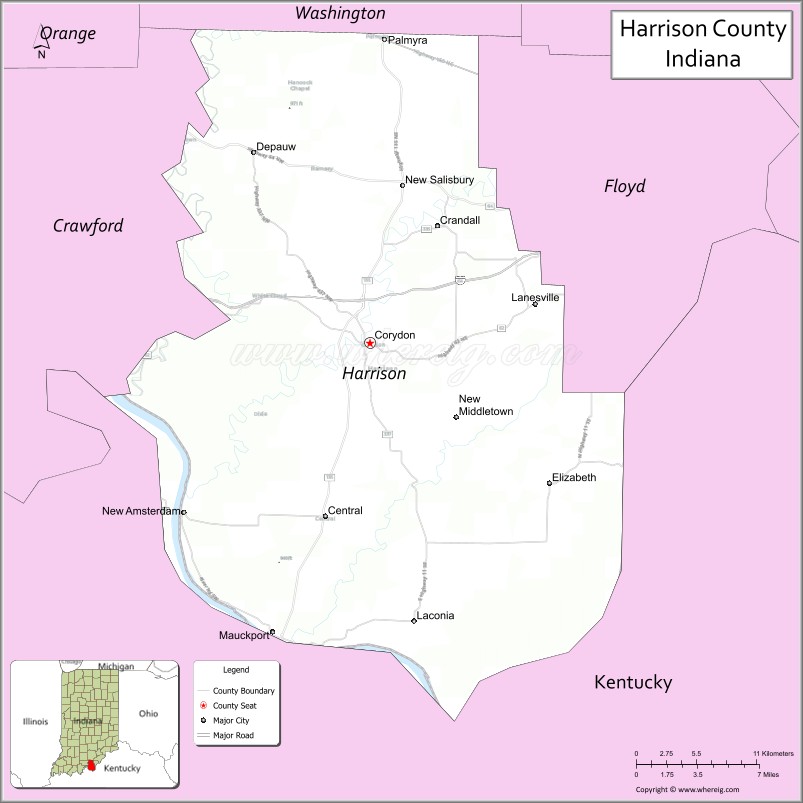
About Harrison County Map, Alabama: The map showing the county boundary, county seat, major cities, highways, water bodies and neighbouring counties.
Related Indiana Maps
About Harrison County, Indiana
Jay County is a county located in the U.S. state of Indiana. It`s county seat is Portland. As per 2020 census, the population of Jay County was 20248 and population density of Jay was square miles. According to the United States Census Bureau, the county has a total area of 384 sq mi (995 km2). Jay County was established on -23702.
Harrison County Facts
| Continent | North America |
| Country | United States |
| State | Indiana |
| County Seat | Corydon |
| Largest City/Town | Corydon |
| Established | 1808 |
| Total Area | 486 sq mi |
| Land Area | 485 sq mi |
| Water Area | 1.5 sq mi |
| Population | 40,515 (Census 2020) |
| Population Density | 84 people per sq mi |
| Time Zone | Eastern Time Zone (ET) |
| Major Highways | I-64, IN-11, IN-62, IN-64, IN-135 |
| Neighboring Counties | Washington County (north), Floyd County (east), Meade County, KY (south), Breckinridge County, KY (southwest), Crawford County (west) |
| Famous For | Indiana’s first state capital, historic Corydon, caves |
| Top Attractions | Corydon Capitol State Historic Site, Squire Boone Caverns, O'Bannon Woods State Park |
| Official Website | https://harrisoncounty.in.gov/ |
Cities and Towns in Harrison County, Indiana
- Corydon (county seat) – 3,122 (Census 2020)
- Lanesville – 614 (Census 2020)
- Mauckport – 81 (Census 2020)
- New Middletown – 95 (Census 2020)
- Palmyra – 1,513 (Census 2020)
Roads and Highways in Harrison County, Indiana
Harrison County is served by major highways that connect it to Louisville and other parts of southern Indiana.
- Interstate 64 (I-64) – east-west route connecting the county to Louisville and Evansville
- Indiana State Road 11 – north-south highway linking Lanesville to Mauckport
- Indiana State Road 62 – runs along the Ohio River connecting Corydon to nearby towns
- Indiana State Road 64 – connects Corydon to Salem and Princeton
- Indiana State Road 135 – north-south route linking Corydon to Salem and Paoli
Neighboring Counties of Harrison County
- Washington County (north)
- Floyd County (east)
- Meade County, Kentucky (south)
- Breckinridge County, Kentucky (southwest)
- Crawford County (west)
Top Attractions in Harrison County, Indiana
Harrison County offers a rich history along with natural attractions and outdoor recreation opportunities.
- Corydon Capitol State Historic Site – former state capital building of Indiana
- Squire Boone Caverns – cave tours and historic attractions
- O'Bannon Woods State Park – hiking, camping, and scenic views
- Harrison-Crawford State Forest – large forest area for outdoor recreation
- Indian Creek Trail – scenic trail for hiking and biking
- Corydon Downtown – historic district with shops and restaurants
Distance from Harrison County to Nearby Cities
- Harrison County to Louisville – 25 mi (40 km)
- Harrison County to Indianapolis – 110 mi (177 km)
- Harrison County to Evansville – 120 mi (193 km)
- Harrison County to Bloomington – 70 mi (113 km)
- Harrison County to Cincinnati – 120 mi (193 km)
FAQs about Harrison County
Harrison County is located in southern Indiana along the Ohio River.
The county seat is Corydon, which is also the largest town in the county.
It is known for being Indiana’s first state capital and its historic sites and caves.
Yes, it is popular for history, caves, and outdoor recreation.
The county is served by I-64 and several Indiana state roads including IN-62 and IN-135.
- Adams County Map, IN
- Allen County Map, IN
- Bartholomew County Map, IN
- Benton County Map, IN
- Blackford County Map, IN
- Boone County Map, IN
- Brown County Map, IN
- Carroll County Map, IN
- Cass County Map, IN
- Clark County Map, IN
- Clay County Map, IN
- Clinton County Map, IN
- Crawford County Map, IN
- Daviess County Map, IN
- Dearborn County Map, IN
- Decatur County Map, IN
- DeKalb County Map, IN
- Delaware County Map, IN
- Dubois County Map, IN
- Elkhart County Map, IN
- Fayette County Map, IN
- Floyd County Map, IN
- Fountain County Map, IN
- Franklin County Map, IN
- Fulton County Map, IN
- Gibson County Map, IN
- Grant County Map, IN
- Greene County Map, IN
- Hamilton County Map, IN
- Hancock County Map, IN
- Harrison County Map, IN
- Hendricks County Map, IN
- Henry County Map, IN
- Howard County Map, IN
- Huntington County Map, IN
- Jackson County Map, IN
- Jasper County Map, IN
- Jay County Map, IN
- Jefferson County Map, IN
- Jennings County Map, IN
- Johnson County Map, IN
- Knox County Map, IN
- Kosciusko County Map, IN
- LaGrange County Map, IN
- Lake County Map, IN
- LaPorte County Map, IN
- Lawrence County Map, IN
- Madison County Map, IN
- Marion County Map, IN
- Marshall County Map, IN
- Martin County Map, IN
- Miami County Map, IN
- Monroe County Map, IN
- Montgomery County Map, IN
- Morgan County Map, IN
- Newton County Map, IN
- Noble County Map, IN
- Ohio County Map, IN
- Orange County Map, IN
- Owen County Map, IN
- Parke County Map, IN
- Perry County Map, IN
- Pike County Map, IN
- Porter County Map, IN
- Posey County Map, IN
- Pulaski County Map, IN
- Putnam County Map, IN
- Randolph County Map, IN
- Ripley County Map, IN
- Rush County Map, IN
- St Joseph County Map, IN
- Scott County Map, IN
- Shelby County Map, IN
- Spencer County Map, IN
- Starke County Map, IN
- Steuben County Map, IN
- Sullivan County Map, IN
- Switzerland County Map, IN
- Tippecanoe County Map, IN
- Tipton County Map, IN
- Union County Map, IN
- Vanderburgh County Map, IN
- Vermillion County Map, IN
- Vigo County Map, IN
- Wabash County Map, IN
- Warren County Map, IN
- Warrick County Map, IN
- Washington County Map, IN
- Wayne County Map, IN
- Wells County Map, IN
- White County Map, IN
- Whitley County Map, IN
- Alabama Counties
- Alaska boroughs
- Arizona Counties
- Arkansas Counties
- California County Map
- Colorado Counties
- Connecticut Counties
- Delaware Counties
- Florida County Map
- Georgia County Map
- Hawaii Counties
- Idaho Counties
- Illinois Counties
- Indiana Counties
- Iowa Counties
- Kansas Counties
- Kentucky Counties
- Louisiana Counties
- Maine Counties
- Maryland Counties
- Massachusetts Counties
- Michigan County Map
- Minnesota Counties
- Mississippi Counties
- Missouri Counties
- Montana Counties
- Nebraska Counties
- Nevada Counties
- New York Counties
- New Hampshire Counties
- New Jersey Counties
- New Mexico Counties
- North Carolina Counties
- North Dakota Counties
- Ohio County Map
- Oklahoma Counties
- Oregon Counties
- Pennsylvania Counties
- Rhode Island Counties
- South Carolina Counties
- South Dakota Counties
- Map of Tennessee
- Texas County Map
- Utah Counties
- Vermont Counties
- Virginia Counties
- Washington Counties
- West Virginia Counties
- Wisconsin Counties
- Wyoming Counties