By Whereig Editors, Reviewed by Mukesh Kumar| Updated On: May 02, 2026 | 20:16 ET
Map of Pike County - Pike County is a county located in the U.S. state of Indiana. Pike County Map showing cities, highways, important places and water bodies. Get Where is Pike County located in the map, major cities in Pike county, population, areas, and places of interest.
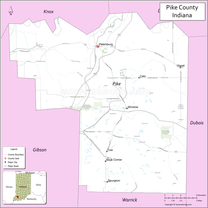
Map of Pike County, Indiana
About Pike County Map, North Dakota: The map showing the county boundary, county seat, major cities, highways, water bodies and neighbouring counties.
More North Dakota Maps & Info
About Pike County, Indiana
Rush County is a county located in the U.S. state of Indiana. It`s county seat is Rushville. As per 2020 census, the population of Rush County was 16672 and population density of Rush was square miles. According to the United States Census Bureau, the county has a total area of 408 sq mi (1,057 km2). Rush County was established on -28488.
Pike County Facts
| Continent | North America |
| Country | United States |
| State | Indiana |
| County Seat | Petersburg |
| Largest City/Town | Petersburg |
| Established | 1816 |
| Total Area | 341 sq mi |
| Land Area | 334 sq mi |
| Water Area | 6.9 sq mi |
| Population | 12,845 (Census 2020) |
| Population Density | 38 people per sq mi |
| Time Zone | Eastern Time Zone (ET) |
| Major Highways | IN-56, IN-57, IN-61, IN-64, IN-257 |
| Neighboring Counties | Gibson County (south), Dubois County (east), Daviess County (north), Knox County (west), Warrick County (southwest) |
| Famous For | Coal mining, rural landscapes, White River |
| Top Attractions | White River, Petersburg Downtown, Pike County Fairgrounds |
| Official Website | https://pikekounty.in.gov/ |
Cities and Towns in Pike County, Indiana
- Petersburg (county seat) – 2,383 (Census 2020)
- Winslow – 864 (Census 2020)
- Spurgeon – 207 (Census 2020)
- Otwell – 434 (Census 2020)
Roads and Highways in Pike County, Indiana
Pike County is served by highways that connect it to southwestern Indiana and surrounding regions.
- Indiana State Road 56 – east-west route connecting Petersburg to Jasper and Washington
- Indiana State Road 57 – north-south highway linking the county to Evansville and Washington
- Indiana State Road 61 – connects Petersburg to Vincennes and Boonville
- Indiana State Road 64 – east-west route connecting Winslow to Princeton and Huntingburg
- Indiana State Road 257 – connects the county to Oakland City and surrounding communities
Neighboring Counties of Pike County
- Gibson County (south)
- Dubois County (east)
- Daviess County (north)
- Knox County (west)
- Warrick County (southwest)
Top Attractions in Pike County, Indiana
Pike County offers small-town charm, outdoor recreation, and local history.
- White River – popular for fishing, boating, and scenic views
- Petersburg Downtown – historic area with shops and dining
- Pike County Fairgrounds – hosts annual fairs and community events
- Hornady Park – local park with recreational facilities
- Winslow Downtown – small-town atmosphere with local businesses
- Patoka River area (nearby) – outdoor recreation and wildlife viewing
Distance from Pike County to Nearby Cities
- Pike County to Evansville – 40 mi (64 km)
- Pike County to Jasper – 25 mi (40 km)
- Pike County to Indianapolis – 120 mi (193 km)
- Pike County to Louisville – 100 mi (161 km)
- Pike County to Terre Haute – 90 mi (145 km)
FAQs about Pike County
Pike County is located in southwestern Indiana.
The county seat is Petersburg, which is also the largest city in the county.
It is known for coal mining, rural landscapes, and the White River.
Yes, it is largely rural with small towns and farmland.
The county is served by several Indiana state roads including IN-56, IN-57, and IN-61.
- Adams County Map
- Barnes County Map
- Benson County Map
- Billings County Map
- Bottineau County Map
- Bowman County Map
- Burke County Map
- Burleigh County Map
- Cass County Map
- Cavalier County Map
- Dickey County Map
- Divide County Map
- Dunn County Map
- Eddy County Map
- Emmons County Map
- Foster County Map
- Golden Valley County Map
- Grand Forks County Map
- Grant County Map
- Griggs County Map
- Hettinger County Map
- Kidder County Map
- LaMoure County Map
- Logan County Map
- McHenry County Map
- McKenzie County Map
- McLean County Map
- McIntosh County Map
- Mercer County Map
- Morton County Map
- Mountrail County Map
- Nelson County Map
- Oliver County Map
- Pembina County Map
- Pierce County Map
- Ramsey County Map
- Ransom County Map
- Renville County Map
- Richland County Map
- Rolette County Map
- Sargent County Map
- Sheridan County Map
- Sioux County Map
- Slope County Map
- Stark County Map
- Steele County Map
- Stutsman County Map
- Towner County Map
- Traill County Map
- Walsh County Map
- Ward County Map
- Wells County Map
- Williams County Map
- Adams County Map, IN
- Allen County Map, IN
- Bartholomew County Map, IN
- Benton County Map, IN
- Blackford County Map, IN
- Boone County Map, IN
- Brown County Map, IN
- Carroll County Map, IN
- Cass County Map, IN
- Clark County Map, IN
- Clay County Map, IN
- Clinton County Map, IN
- Crawford County Map, IN
- Daviess County Map, IN
- Dearborn County Map, IN
- Decatur County Map, IN
- DeKalb County Map, IN
- Delaware County Map, IN
- Dubois County Map, IN
- Elkhart County Map, IN
- Fayette County Map, IN
- Floyd County Map, IN
- Fountain County Map, IN
- Franklin County Map, IN
- Fulton County Map, IN
- Gibson County Map, IN
- Grant County Map, IN
- Greene County Map, IN
- Hamilton County Map, IN
- Hancock County Map, IN
- Harrison County Map, IN
- Hendricks County Map, IN
- Henry County Map, IN
- Howard County Map, IN
- Huntington County Map, IN
- Jackson County Map, IN
- Jasper County Map, IN
- Jay County Map, IN
- Jefferson County Map, IN
- Jennings County Map, IN
- Johnson County Map, IN
- Knox County Map, IN
- Kosciusko County Map, IN
- LaGrange County Map, IN
- Lake County Map, IN
- LaPorte County Map, IN
- Lawrence County Map, IN
- Madison County Map, IN
- Marion County Map, IN
- Marshall County Map, IN
- Martin County Map, IN
- Miami County Map, IN
- Monroe County Map, IN
- Montgomery County Map, IN
- Morgan County Map, IN
- Newton County Map, IN
- Noble County Map, IN
- Ohio County Map, IN
- Orange County Map, IN
- Owen County Map, IN
- Parke County Map, IN
- Perry County Map, IN
- Pike County Map, IN
- Porter County Map, IN
- Posey County Map, IN
- Pulaski County Map, IN
- Putnam County Map, IN
- Randolph County Map, IN
- Ripley County Map, IN
- Rush County Map, IN
- St Joseph County Map, IN
- Scott County Map, IN
- Shelby County Map, IN
- Spencer County Map, IN
- Starke County Map, IN
- Steuben County Map, IN
- Sullivan County Map, IN
- Switzerland County Map, IN
- Tippecanoe County Map, IN
- Tipton County Map, IN
- Union County Map, IN
- Vanderburgh County Map, IN
- Vermillion County Map, IN
- Vigo County Map, IN
- Wabash County Map, IN
- Warren County Map, IN
- Warrick County Map, IN
- Washington County Map, IN
- Wayne County Map, IN
- Wells County Map, IN
- White County Map, IN
- Whitley County Map, IN
- Alabama Counties
- Alaska boroughs
- Arizona Counties
- Arkansas Counties
- California County Map
- Colorado Counties
- Connecticut Counties
- Delaware Counties
- Florida County Map
- Georgia County Map
- Hawaii Counties
- Idaho Counties
- Illinois Counties
- Indiana Counties
- Iowa Counties
- Kansas Counties
- Kentucky Counties
- Louisiana Counties
- Maine Counties
- Maryland Counties
- Massachusetts Counties
- Michigan County Map
- Minnesota Counties
- Mississippi Counties
- Missouri Counties
- Montana Counties
- Nebraska Counties
- Nevada Counties
- New York Counties
- New Hampshire Counties
- New Jersey Counties
- New Mexico Counties
- North Carolina Counties
- North Dakota Counties
- Ohio County Map
- Oklahoma Counties
- Oregon Counties
- Pennsylvania Counties
- Rhode Island Counties
- South Carolina Counties
- South Dakota Counties
- Map of Tennessee
- Texas County Map
- Utah Counties
- Vermont Counties
- Virginia Counties
- Washington Counties
- West Virginia Counties
- Wisconsin Counties
- Wyoming Counties